
| No | Name | Description |
|---|---|---|
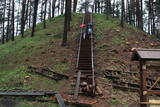 |
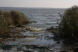
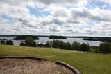
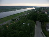
Viens no lielākajiem Augštaitijas pilskalniem, kas 2011. g. pēc vērienīgiem rekonstrukcijas darbiem ir izzināms jaunā kvalitātē - gan no infrastruktūras, gan arī ainaviskā viedokļa, jo iepriekš biezais pamežs (tagad retināts) traucēja uztvert iespaidīgo objektu. Arī no pilskalna plakuma paveras labs skats uz diviem blakus esošajiem ezeriem. Tā virsotnē apskatāms piemiņas akmens, kas vēsta par pirmā Lietuvas valsts prezidenta Antana Smetona (Antanas Smetona) apmeklējumu 1934. g. viņa 60 gadu jubilejā. Pilskalns it ticis apdzīvots jau I tūkstošgadē pirms Kristus. Uzskata, ka 14. – 15. gs. te atradusies hronikās aprakstītā Linkmenu pils. Jaunizveidotā taka pilskalnu savieno ar vēl vienu populāru apskates objektu – Ladakalni. |
|
.JPG?size=160) |
This park was established mostly to protect a wide range of cultural and historical objects such as the Trakai lake castle, the ancient Trakai cloister, the Užutrakai castle, the Bražole castle hill, the heritage of ancient local tribes, etc.
|
|
 |
The Rietavas Park was once the largest landscape park in Lithuania. It was established between 1848 and 1855 in a naturally cleaned forest and reconstructed in 1904 and 1905. This is a very nice park with local bushes and trees, as well as several foreign plants. Various alleys of trees and fragments of the hedges have been preserved along with the white gate, the red gate and a guard's hut. The park has a complex system of bodies of water, including a few ponds, a curvy river and an island that is surrounded by the old river. |
|
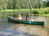 |
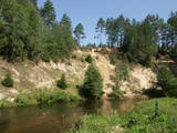
Ūla ir viena no skaistākajām un likumsakarīgi – arī populārākajām Lietuvas ūdenstūristu upēm. Tās galvenā pievilcība ir skaistā ainava ar augstajiem upes krastiem, kuros slejas iespaidīgas smilšu kraujas līdzīgi kā Irbes krastos Latvijā. Laivošanu var sākt no Mančagires (Mančiagirė) vai Zervinos ciemiem un turpināt līdz Ūlas ietekai Merķē un tālāk pa Merķi līdz pat Merķinei un Nemunai. Ūla nav plata, taču posmā no Zervinos ciema tajā nav neviena koku aizgāzuma vai cita šķēršļa, kuram laiva būtu jānes apkārt. Ašā straume, asie līkumi, dzidrais ūdens un tajā redzamā zemūdens pasaule rada patiesi patīkamu sajūtu! Upes krastos atrodas gan publiskas (apsaimnieko Lietuvas valsts meži), gan privātas ūdenstūristu apmetnes un atpūtas vietas. Šī ir vienīgā Baltijas upe, kur ūdenstūristiem ir jāpērk licence. Ūlas krastos atrodas divi interesanti apskates objekti – Ūlas atsegums (Ūlos atodanga) un spēcīgs avots – Ūlas acs (Ūlos akis). Savukārt, Merķe jau ir jau krietni platāka upe, taču ar acīm redzamu straumi un dažviet pat jaukām straujtecēm. Kaut arī Merķes krasti ir mazapdzīvoti, tajos atradīsim piemērotas nakšņošanas vietas. Pa Ūlu un Merķi no Zervinos līdz Merķinei sanāk „mierīgs” pusotras - divas dienas ilgs brauciens. |
|
 |
Lietuvas lielākais sūnu purvs, kura aizsardzības nolūkā ir izveidots Čepkeļu dabas rezervāts (Čepeklių gmatinis rezervatas). Tas izvietojies starp Dzūkijas nacionālā parka dienvidaustrumu daļu un Baltkrieviju. No Marcinkones pa smilšainu meža ceļu (~ 9 km turp - atpakaļ) ar kājām vai divriteni (arī nelielu tūrisma autobusu līdz 20 vietām) var nokļūt līdz purva malai, kur mežainās kāpās un purvā izveidota 1,5 km gara dabas taka un skatu tornis, no kura labi pārredzama purva rietumdaļa. Pirms došanās uz Čepkeļu purvu, ir jāreģistrējas Dzūkijas nacionālā parka apmeklētāju centrā (Šilagėlių gatve 11), kas meklējams aiz dzelzceļa pārbrauktuves. Te apskatāma neliela nacionālajam parkam un rezervātam veltīta ekspozīcija. |
|
 |
Das beinah 100 km langes und bis zu 36 km breites aus dem Süßwasser bestehende Haff, das im Norden mit der Ostsee verbunden ist. Das Haff trennt vom Merr die eindrucksvolle Kurische Nehrung. Ins Kurische Haff mündet der größte Fluss Litauens Nemunas ein. |
|
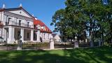 |
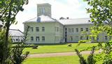
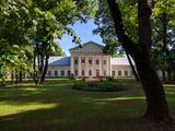
This mixed-type park dates back to the latter half of the 19th century and has remained all but unchanged. It is in a lovely place between two lakes, and its spatial structure was preserved when it was restored. The park covers 10 ha and has two parts. One is a fairly precisely rectangular territory alongside the state, surrounded by a stand of linden trees and introduced trees. The other part has a natural forest. The largest oak tree in the park has been declared to be a protected element of natural heritage. The mighty trunk of the tree is 6.3 m around, has a 2m diameter and stands 30.5 m high. |
|
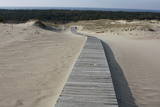 |
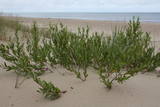
This is the only place in the Baltic States where there is such a vast territory of open-air sand dunes which still change the local terrain very actively because of the wind. The only Sea Museum and Dolphinarium in the Baltic States can be found here.
|
|
 |
Vienu kilometru garā lokveida taka, kas ved pa lielāku nacionālā parka meža masīvu, uzskatāmi attēlo Žemaitijas augstienes un tuvākās apkārtnes reljefa veidošanās vēsturi. No takas augstākā punkta – Mikitai kalna, kas ir sens pagānu upurkalns, paveras (ainaviska stiga) tālākas apkārtnes skats. Kā takas interesantākie apskates objekti ir jāmin teikām apvītais akmens ar Velna pēdu un ar akmeņiem izliktas akas paliekas. |
|
 |
This park is located in the northern part of the Žemaitija Highlands, and much of it is taken up by Lake Plateliai. The park was established to protect lakes, rivers, wetlands and forest ecosystems, as well as the local cultural environment.
|
|
 |
The territory is established in order to protect the dunes and the seashore habitats. There are beautiful beaches and wooded dunes, and the paved Klaipēda–Palanga bikeway trails through the park, which is worth travelling at full length. |
|
 |
This territory in the northern part of the Dzūkija Highlands with lots of hillocks and lakes. The most interesting tourist destination is Velnio duobė (Devil’s Flowerbed) – a funnel-shaped hole that is up to 40 m deep and 200 m wide and is thought to have originated during the Ice Age.
|
|
 |
In der Umgebung von der 52 m hohen Parniddenen Düne sind die im 18. Jh. bei einem Holzeinschlag entstandene Wanderdünen zu sehen! Aussichtsplatz. |
|
 |
This park covers the Nemuna River valley between the villages of Seredžius and Geldaudišķis, with lovely views of castle hills, medieval castles, aristocratic estates, etc., along the shores.
|
|
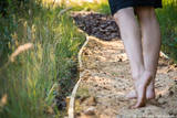 |
Enjoy nature with all of your senses in the Survilai village tourism farm, which is a Swiss village in the Jonavos district. Walk down paths barefoot! The paths are covered with pine cones, puddles, peat, clay, granite, smooth glass, pine needles, hay, an obstacle course, etc. The path is more than a kilometre long, and you will feel unbelievable and positive emotions, as well as an inflow of energy. |
|
 |
Place for bird ringing and bird watching. |
|
 |
Located on an island in Lake Dviragio, the Salu Estate and its park, when viewed from above, are reminiscent of the boundaries of Lithuania. The park to the east of the estate is a mixed-type park and is one of the oldest ones in Lithuania. Back in the day, it was a forest park where trees were never cut down. The park featured maple, linden, elm, aspen and other local trees, and they are now around 200 years old. A winding path links the alley to a park trail by the lake. The various plants and fragments of alleys have survived to the present day. |
|
 |
This territory is Lithuania’s most forested area, and people here have always lived in accordance with nature. Local treasures include berries, mushrooms, honey, clean water from streams and rivers, etc. People here have engaged in various crafts, as well as in beekeeping.
|
|
 |
The only school-based botanical garden in Lithuania was planted in 1989 at the Traupis school. More than 8,000 types of plants grow in the garden, and all of them have been collected by Sigutis Obelevičius. |
|
 |
The botanic garden is part of the Siauliai University and is the newest and smallest botanical garden in Lithuania, covering 6.54 ha of land. |
|


