
| No | Name | Description |
|---|---|---|
 |
This landscape park has survived to the present day and was installed between 1850 and 1860. On one side the territory has a boundary that is the dammed Kruoja River, and on the other side there is a fence made of fieldstones. The English park principles at that time meant that advantage was given to a natural landscape with imitations of nature. There are some 26 types of trees in the park, and some of them were introduced from various parts of the world a few centuries ago. |
|
 |
Nacionālā parka galvenā ainavas dominante. Ezers ir ~ 8,4 km garš un līdz 3,3 km plats. Tā austrumu krasti pārsvarā ir ar mežiem apauguši, ziemeļrietumu krasts – purvains, bet rietumu krastā parādās apdzīvotas sētas un simpātiskā Plateļu (Plateliai) pilsētiņa, kur meklējamas skaistākās skatu vietas. Ezera krastos ir labi attīstīta infrastruktūra - tūristu mītnes, ēdināšanas uzņēmumi (Plateļos), ūdenssporta un atpūtas inventāra noma. Ūdens dzidruma dēļ, Plateļu ezeru ir iecienījuši zemūdens niršanas entuziasti. Ezerā ir vairākas salas, no kurām interesanta ir Pils salas (Pilies sala), uz kuras no 15. – 16. gs. atradās muiža. Pastāv uzskats, ka senie Plateļu apkārtnes iedzīvotāji sākotnēji ir dzīvojuši uz salas, kuru ar krastu savienojis uz pāļiem celts tilts. Jāpiemin, ka 15 gs. pirmoreiz pieminētā Plateļu pilsētiņa atradusies uz Šventorkalņa (Šventorkalnis) kalna. Apkārt Plateļu ezeram ir izveidots ~ 24 km garš velomaršruts. Tā ir ļoti laba iespēja iepazīt parku videi un ceļotāja veselībai draudzīgā veidā. |
|
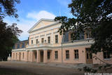 |
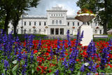
This is one of the most colourful and architecturally interesting parks in Lithuania. It was rebuilt and expanded between 1898 and 1900 by the renowned dendrologist G.F. Kuphaldt. The park had more than 200 types of plants, more than 100 of which are still growing. There are various roads and pathways that offer a sense of the mightiness and beauty of the park. A dendrological trail with markers offers information about 15 rare trees. |
|
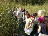 |
Kaut arī Augštaitijas nacionālo parku uzskata par floristiskā ziņā ļoti bagātu teritoriju, šī ir vienīgā vieta, kur varam iepazīt augu valsts bagātību. To īstenot palīdz takas malās izvietotie informācijas stendi. 3,8 km garās lokveida takas sākums ir meklējams Palūšē, Lūšu (Lūšiai) ezera galējā austrumu punktā. Taka ved gar ezera krastu, mežainām kāpām, nelielu strautu ielejām un pa purvāju. Nenomaldīties palīdz krāsu marķējums uz koku stumbriem. |
|
 |
This territory is Lithuania’s most forested area, and people here have always lived in accordance with nature. Local treasures include berries, mushrooms, honey, clean water from streams and rivers, etc. People here have engaged in various crafts, as well as in beekeeping.
|
|
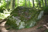 |
Vienu kilometru garā lokveida taka, kas ved pa lielāku nacionālā parka meža masīvu, uzskatāmi attēlo Žemaitijas augstienes un tuvākās apkārtnes reljefa veidošanās vēsturi. No takas augstākā punkta – Mikitai kalna, kas ir sens pagānu upurkalns, paveras (ainaviska stiga) tālākas apkārtnes skats. Kā takas interesantākie apskates objekti ir jāmin teikām apvītais akmens ar Velna pēdu un ar akmeņiem izliktas akas paliekas. |
|
 |
Located on an island in Lake Dviragio, the Salu Estate and its park, when viewed from above, are reminiscent of the boundaries of Lithuania. The park to the east of the estate is a mixed-type park and is one of the oldest ones in Lithuania. Back in the day, it was a forest park where trees were never cut down. The park featured maple, linden, elm, aspen and other local trees, and they are now around 200 years old. A winding path links the alley to a park trail by the lake. The various plants and fragments of alleys have survived to the present day. |
|
 |
This estate is surrounded by an ancient and geometric landscape. During the latter half of the 19th century, it had a landscape style with various elements of geometry. The park covers 4.2 ha and has ancient linden, maple, elm, oak and other decorative bushes, with more than 20 types of plants that have turned into wood. |
|
 |
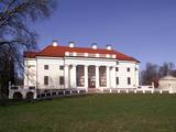
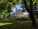
The Plunge Estate is famous because its park, which is a mixed-type park that was established during the 18th and 19th century at a holy forest that used to be a sacrificial place. The pride and joy of the park is the Thunder oak tree, a legendary weeping linden tree and an elm tree with five trunks. The lord of the state ordered the digging of seven ponds with cascades. These are linked by rock bridge sluices. The Babrungo River, which flows alongside the estate offers an outstanding landscape for the park. |
|
 |
In terms of territory, it is the most impressive dune range in the Baltics. This is the only place in the Baltics, where one can enjoy open dune sands that are still active and, under the influence of wind, form the so-called eolian relief forms. There are trails, wooded trails and a paved bikeway for the conveniences of visitors. In order to protect the dune, The Dunes of Curonian spit National Park has been established . |
|
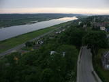 |
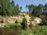
This park covers the Nemuna River valley between the villages of Seredžius and Geldaudišķis, with lovely views of castle hills, medieval castles, aristocratic estates, etc., along the shores.
|
|
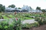 |
This botanical garden was opened in 1923 as a scholarly centre. The garden covers more than 60 hectares, and approximately 30 ha are open to the public. |
|
|
|
Eine der malerischischen Burgberge am Fluss Nemunas mit schöner Sicht aufs Flusstal. In 13 – 14 Jh. befand sich hier eine militäre Festung, die nicht erhalten ist. |
|
 |
The botanical garden was established in 1993 in the lovely Dane River valley. It covers approximately 9.3 hectares, and in 2002, it was given the status of a dendrological park. |
|


