
| No | Name | Description |
|---|---|---|
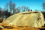 |
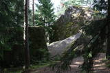
This is the second largest rock in the Baltic States in terms of size (728 m3). It is the only rock in the Baltic States with this form and size. It is 7 m high, 19 m long, 11 m wide, and 58 m in perimeter. Kabelikivi looks like a cliff that is halfway sunk into the earth. During the Ice Age, the rock “travelled” to this location from southern Finland. It is made of granite, and there are two other very impressive rocks alongside it.
|
|
 |
This is an entirely forested island in the Bay of Finland, ~14 km from Tallinn. A network of small pathways covers the entire island. Recommended hike along the seashore of the island, which will offer dunes, as well as a coastline that is sandy in some parts, rocky in others, and covered with reeds in still others (~9 km). A ferry boat will take you to the island from the Pirita port.
|
|
 |
The Kassari Island is the fifth largest Estonian island, and it is found to the South of the Hiiumaa Island. There are two dams between the two islands, and a road for motor vehicles has been installed atop them.
|
|
 |
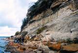
This is one of the few places in the Baltic States where one can find Devonian period sandstone cliffs featuring abrasion caves, arches, etc. The cliffs are on the shores of Lake Peipsi (Peipsi järv), near Kallaste, and they are between two and four (in some cases – nine) metres high, stretching for a distance of around one km.
|
|
 |
Die Größe dieses Feldsteins ist eindrucksvoll, obwohl er nach dem Volumen (262 m3) nur der 16. größte Feldstein Estlands ist. Die Länge beträgt 10,7 m, Breite – 6,5 m, Umfang – 27,8 m. |
|
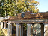 |
Vom 19. Jh. ist der Domberg ein offentlicher Park mit Pfaden, Gehwegen, Brücken (Engelsbrücke, Teufelsbrücke) und den Denkmälern für die Wissenschaftler der Tartu Universität. Hier befinden sich die Domkirche, das Anatomicum, das Observatorium u.a. interessante Objekte. |
|
 |
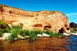
This cliff is made of sandstone (its lower part) and limestone (the upper part). It is up to 30 m high, and it is part of the Northern Estonian set of cliffs along the shore of the Bay of Finland. This is a popular tourism destination and viewing location. Recommended Hike along the bottom of the cliff (a rocky beach) in one direction, and then along the top of the cliff to get back (~2 km). From the top of the cliff, you can see a broad segment of the shoreline territory, all the way to Tallinn.
|
|
 |
1,7 km gara lokveida taka, kas iepazīstina ar dažādiem meža biotopiem, to iemītniekiem un meža apsaimniekošanas pamatprincipiem. Apmeklētāju ērtības nolūkā ir izveidotas koka laipas un neliels skatu tornis. |
|
 |
Lai nokļūtu līdz šim tornim, ir jāveic apmēram 20 – 30 min ilgs pārgājiens pa dabas taku no Penijē muižas gar Penijegi (Penijõgi) kreiso krastu. Te redzami bebru darbi un to celtās zaru mājas. No torņa paveras skats uz Kazari deltu, kas dabā izpaužas kā monolīts un nepārskatāms niedrājs. To vairākās daļās sadala Kazari un mazāka izmēra upītes. Katrai deltas daļai ir savs vēsturiskais nosaukums: no torņa pa kreisi no Penijegi redzama Lihula meri (Lihulas „jūra”), bet tās labajā pusē - Kloostri meri (Klostri „jūra”). Putnu vērotāji var iziet garāku (7 km) dabas takas loku, kas ved pa palieņu pļavām. Jārēķinās, ka pavasaros būs nepieciešami piemēroti apavi! Pļavas ierobežotās platībās apsaimnieko mājdzīvnieki, tādēļ neaizmirstiet aizvērt vārtiņus aiz sevis un netraucējiet to ikdienas gaitas! No maršruta nav atļauts novirzīties, lai netraucētu putnus. |
|
 |
The biggest sea island in Estonia. In translation - "Land of The Islands". A bridge, where cyclists can drive connects Saaremaa island to Muhu island . |
|
 |
This is a forested island in the Bay of Finland which is the 6th largest Estonian island and is found 14 km to the N of Tallinn. Two decades ago it was a closed zone, because the Soviet Union had a highly secretive manufacturing plant for maritime mines here.
|
|
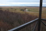 |
Suitsu tornis celts 1979. g. kā pirmais Matsalu rezervāta metāla tornis. To atjaunoja 1998. g. Torņa augstums ir 21 m, tādēļ no tā paveras izcila dabas un kultūrainava uz Kazari deltas niedrājiem un blakus esošo Suitsu upi (Suitsu jõgi), kuras krastā ir uzceltas vairākas zvejnieku laivu būdas. |
|
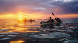 |
The company runs wildlife tours: rafting in early spring, kayaking in summer (with beaver watching upon request), bog and snowshoeing round the year, kick-sledging in winter. Our experienced guides tell exciting stories of wildlife and history. |
|
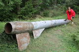 |
Der weiteste Nordpunkt der Juminda Halbinsel mit einer Raketen-Attrappe der Sowjetarmee, der alten Grabstätten, dem Juminda-Leuchtturm und einem Denkmal für die Opfern des Zweiten Weltkriegs. |
|
 |
Četrus kilometrus gara marķēta lokveida taka, kas ved pa lielāku meža masīvu, iepazīstina ne tikai ar augiem un dzīvniekiem, bet arī mežsaimniecības tradīcijām. Takas sākums atrodas pie nelielā Perejerves ciema, uz kuru paveras labs skats no tuvējā paugura. Pie autostāvlaukuma izveidota atpūtas un piknika vieta. |
|
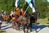 |
Tihuse farm provides accommodation and horse riding from trekking to carriage rides. A signposted heritage trail starts at the farm and tells the story of people and Nature; you can also learn about old beliefs and customs. The teahouse exhibits photos of places linked to Muhu island’s heritage. |
|
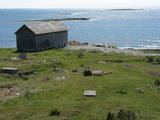 |
No Vilsandi bākas un tai tuvākās apkaimes ir labi saskatāmas leģendārās Vaikas salas. Tām ir piešķirts rezervāta statuss, tādēļ salas var apskatīt tikai no attāluma. Mazākā no saliņām - Kullipank ir tikai pārdesmit metrus diametrā. Tā ir jūras ūdeņu izrobots zemas un asas dolomīta klints fragments, kas klāts ar oļiem, nelieliem laukakmeņiem un kādu atsevišķi stāvošu lakstaugu. Domājams, ka vētru laikā tā pazūd zem jūras ūdens. Savukārt, Alumine Vaigas – Apakšējā Vaikas sala ir lielākā no sešām salām. Šīs salas diametrs ir ~ 150 m un tā paceļas vismaz kādus divus metrus virs jūras līmeņa. Uz salas ir bagātīga veģetācija un pat kāds zems krūms salas centrā. Redzami arī metru augsti atsegumi. Uz salas vēl joprojām atrodas 20. gs. sākumā celto „putnu māju” paliekas, kas bija domātas ligzdojošo putnu piesaistīšanai. |
|
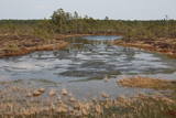 |
Iepazīstina ar Somā nacionālā parka lielākā purva – Kureso (Kuresoo) ziemeļaustrumu daļu, kur redzamas purva ezeriņu un lāmu ainavas. Takas sākumā atrodas igauņu komponista, ērģelnieka un folkloras vācēja Marta Sāra (Mart Saar) (1882. – 1963.) dzimtās mājas. To apkaimē pļavas apsaimnieko aitas. Lokveida takas garums ir 4,2 km. |
|
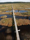 |
This reserve was set up to protect local swamps and surrounding wetlands. Please note that before you can visit the reserve, you must register with the local administration and visitor centre in the village of Tooma.
|
|
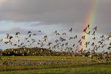 |
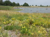
This is one of the most popular bird-watching locations in Estonia, and during spring and autumn migration there are a great many different kinds of birds resting and feeding in the meadows and shallow coastal waters of the Bay of Matsalu and the Kasari River.
|
|


