
| No | Name | Description |
|---|---|---|
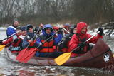 |
The company runs wildlife tours: kayak trips at sea in summer, bogshoeing in bogs in autumn, snowshoeing trips in winter and canoeing on rivers in spring. |
|
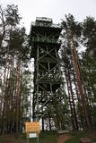 |
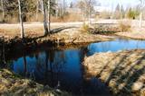
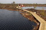
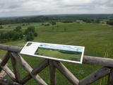
Viens no diviem nacionālā parka skatu torņiem, kas atrodas ~ 1,5 km ziemeļos no Ehijerva ezera (Ähijärv). Tornis ir veiksmīgi „nomaskēts” nelielā priežu pudurī, tādēļ tas „nebojā” izcilo dabas un kultūrainavu, kas paveras no tā skatu platformas. Pie autostāvlaukuma ir izveidota labiekārtota atpūtas vieta. |
|
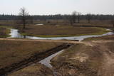 |
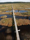
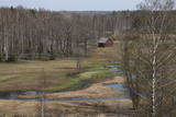
Divarpus kilometrus gara taka (vienā virzienā) aizved līdz Hallistes palieņu pļavām, kur Hallistes upes labajā krastā ir uzcelts divstāvīgs koka skatu tornis. No tā paveras visaptverošs skats uz atjaunotajām (izcirsti krūmi) Hallistes palieņu pļavām. Pavasara palu laikā no torņa redzamā apkārtne un tornis atrodas ūdenī. |
|
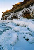 |
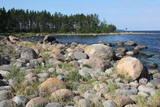
At the end of the Pakri peninsula is the most visually impressive shoreline cliff in the Baltic States – the Pakri cliff (Pakri pank), which is as much as 24 metres high. During cold winters, streams which flow from the layers of limestone cliffs form fantastic and unusual shapes of ice.
|
|
 |
This is the 11th largest Estonian island, and its central section is covered by a broadleaf forest (linden, oak, elm and other trees) that is more than 100 years old. Along the shores, the Abruka Island has meadows and small areas of wetlands. Only the northern part of the island is populated. Few tourists come to call, which means that the island is relatively untouched by humankind.
|
|
 |
One of the largest karst areas in Estonia is found here. The unique Witch’s well is one of the most interesting parts of this area. During spring floods (not every year, and for only a short period of time), the well erupts with underground river waters to create an unusually powerful karst stream that can pump out as much as 100 litres per hour.
|
|
 |
This reserve was set up to protect local swamps and surrounding wetlands. Please note that before you can visit the reserve, you must register with the local administration and visitor centre in the village of Tooma.
|
|
 |
The word “Luitemaa” means “land of the dunes” in Estoninan. This coastline territory stretches for 13 km between Vöiste and Häädemeste with shallow waters, large coastal plains, Estonia’s highest dunes, and the Tokuse swamp (Tokuse raba). There are lots of birds here.
|
|
 |
Ap 6 km garā pussala ir vieta, kur jānokļūst tiem, kas grasās doties vienā no neparastākajiem pārgājieniem pāri jūras šaurumam. Cauri Kūsnemmes pussalai līdz tās ziemeļu daļai iet šaurs un ļoti līkumains grants ceļš (ar garāku tūristu autobusu jābrauc lēni un uzmanīgi), kura galā izveidots autostāvlaukums, neliels namiņš, kur patverties lietus un vēja laikā, kā arī informācijas stends. Turpat redzamas divas Padomju armijas „KRAZ” tipa automašīnas. Lai sasniegtu robežkontroles posteni, Padomju robežsargi brauca pa jūru un mazajām saliņām, kas kā pērļu virtene savieno Kūsnemmes pussalas galu ar Vilsandi salas dienviddaļu. Turpat divas desmitgades pēc Igaunijas neatkarības atjaunošanas „KRAZ” automašīnu kravas kastēs vasaras laikā uz Vilsandi vizināja tūristus, taču spēkrati savu mūžu ir nokalpojuši un unikālais piedāvājums vairs nav spēkā! Ko darīt? Pa mazajām saliņām uz Vilsandi var doties ar kājām. To var īstenot tikai siltā laikā, kad nav gaidāms stiprs vējš un ir zināma laika prognoze vismaz divām tuvākajām dienām. Kā sava veida orientieris var kalpot augstsprieguma elektrolīnija. Kopumā ir jārēķinās arī ar 1 h 40 – 2 h ilgu un ~ 4 km garu gājienu. Dziļākā vieta (ja ietur pareizo „kursu”) atrodas pārgājiena sākumdaļā, kur starp saliņām izveidots laivu ceļš - ~ 1 m dziļa vieta atkarībā no vēja virziena un ūdens līmeņa. Zināmu priekšstatu par maršrutu sniegs redzamā ainava, kas paveras no skatu torņa. Kaut arī šis maršruts tiek reklamēts dažādos informatīvajos materiālos, atbildību par tā veikšanu uzņemas katrs pats! |
|
 |
The word “Soomaa” means “land of the swamps” in Estonian. There are several major swamps in this area, along with rivers, lowland meadows, wetland forests, and other biotopes that are of key importance in terms of the diversity of species. Major floods occur here in the spring, which is known by locals as the “fifth season''. The fifth season is the best time to explore the landscape of Soomaa. |
|
 |
Die Größe dieses Feldsteins ist eindrucksvoll, obwohl er nach dem Volumen (262 m3) nur der 16. größte Feldstein Estlands ist. Die Länge beträgt 10,7 m, Breite – 6,5 m, Umfang – 27,8 m. |
|
 |
Bijušā piecstāvīgā metāla skatu torņa apkaimē plešas Lemmjegi upes palieņu pļavas. Netālu atrodas kādreizējā Oksas kroga (Oksa kõrts) vieta, kur saglabājies iespaidīgs manteļskurstenis. Apkaimes apskatei izveidota 0,8 km gara koka laipu taka. |
|
 |
~ 3 – 5 km gara taka, kas ved pa veco ceļu gar Tēramā upes (Tõramaa jõgi) kreiso krastu. Takas malās izvietoti interaktīvi elementi bērniem, kas palīdz labāk uztvert dabā notiekošo. Taku ieskauj mitrie meži un palieņu pļavas, kas palu laikā atrodas zem ūdens. Tēramā (Tõramaa) ciemā apkārtnē atrastas cilvēka darbības pēdas jau no akmens laikmeta. |
|
 |
Litorīnas jūras laikā (pirms ~ 6000 gadiem) Saleveres Salumegi kalns bija sala, bet mūsdienās tas kā izteikta kāple (īpaši - ziemeļu pusē) paceļas virs Piejūras līdzenuma. Salumegi ziemeļu pusē slejas 4 - 5 metrus augsts kaļķakmens atsegums – silūra perioda (> 400 mlj. gadu) koraļļu rifa paliekas, kuru noskalojuši Litorīnas jūras viļņi. Atseguma piekājē izplūst Acu avots, kam piedēvē dziednieciskas īpašības. Salumegi apskates nolūkos izveidota lokveida taka (1,5 km). No kalna augšas paveras labs skats uz Matsalu līci. Šeit atradies arī sens pilskalns. |
|
 |
This is the first national park in Estonia and the Baltic States. Perfect for a day trip out from Tallinn for a hiking trip and nature watching. It was established in 1971 to protect the area that is along the Bay of Finland – the shoreline, forests, swamps, meadow biotopes, species, natural monuments, rocks, waterfalls, cliffs and cultural monuments such as ancient cemeteries, castle hills, baronial estates, fishing villages, etc. |
|
 |
In Estonian, Luitemaa means ‘the land of dunes’. It is the seashore territory of the Gulf of Pärnu, 13 km between Vöiste and Häädemeeste with shallow waters, vast coastal meadows, the highest dune range in Estonia and the Tolkuse Mire (Tolkuse raba). The Tolkuse mire trail (~2.2 km) and watching tower are available for dune and mire sightseeing tours. Situated in Luitemaa Nature Reserve. |
|
 |
This park is in a region of hillocks in the Karula highlands, and Lake Ähijärve is at its centre. The park offers a cultural environment of small farms, and it was set up to protect the unique cupola-shaped hillocks of the area. Main attractions: Scenic Lake Ähijärv (176ha), Rebasemõisa Tornimägi hill (137.8 m above sea level), undulating landscapes. |
|
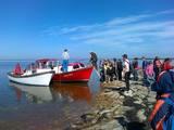 |
The company provides wildlife tours – seal watching, walking, cycling or skiing trips, rubber boat trips to Vilsandi and other islands, orchid trips, and trips to learn about culture and life of the manors, towns and villages, crafts and seafaring. Miku forest park in Vilsandi National Park is where visitors can learn about and try various forestry jobs. |
|
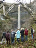 |
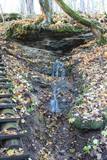
This is a cliff with various levels. Known as the North Estonian cliff, it stretches all along the shore of the Bay of Rīga in Estonia, including some of the local islands. The most expressive part in geological and landscape terms is the Saka-Ontika-Toila cliff, which is around 22 km long and offers an unusual natural environment. The cliff is as much as 53 m high, and it has a fairly virginal forest along its slopes. The layers of clay, sandstone, limestone, etc., come from the Cambrian and Ordovician periods. The Valaste juga (Valaste waterfall) is 24 metres high. After a longer period of freezing temperatures, the waterfall has a particularly impressive appearance. Seasonal waterfalls (8-10 m) can be found near the villages of Ontika and Toila.
|
|
 |
Karulas augstienes augstākais reljefa punkts (137 m.vjl.), kas virs tuvākās apkārtnes paceļas par ~ 60 m. Torņa kalnā ir uzbūvēts skatu tornis ar ļoti plašu apkārtskatu. Uz tā platformas ir novietoti panorāmas fotoattēli, kuros atzīmēti zīmīgākie plašākā apkaimē redzamie objekti – apdzīvotas vietas, pilskalni, baznīcu torņi u.c. Turpat izveidota atpūtas vieta un meklējams Rebases ainavu takas sākums. |
|


