
| No | Name | Description |
|---|---|---|
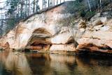 |
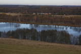
This is one of the most beautiful ancient river valleys in Estonia – 12 km long with nearly 40 revealed Devonian sandstone cliffs. Among these, the most important ones are Viira müür, Kalamatu müür, and Põdramüür.
|
|
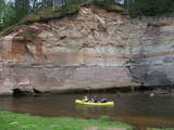 |
This ancient river valley stretches from Koorvere to the Otteni Windmill, and there are nearly 40 revealed sandstone cliffs from the Devonian age. Two of them, Väike and Suur Taevaskoja (the latter is 22 m high) are popular tourist destinations.
|
|
 |
Naissaar is a small island near Tallinn which was exclusively used by the Soviet military from 1945 to 1993. Attractions on the island include walking trails, varied habitats, a narrow-gauge railway, fortifications from the early 20th C, and a Soviet naval mines factory. |
|
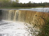 |
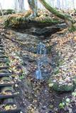
This is one of the greatest waterfalls in the Baltic States – 8 m high and up to 70 m wide. It is most impressive in the spring and after strong rains. The waterfall and its ~300 m canyon emerged from the limestone of the Ordovician Period. You may spot some fossils there. When the water is low, courageous people try to ford the river both above and below the waterfall. The limestone and the falling water have established a unique “tunnel” there.
|
|
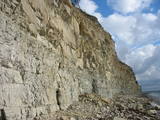 |
The highest and most beautiful wall of cliffs on Saaremaa Island (up to 21 m high), stretching along some 3 km. During strong winds from the W or NW, a part of the cliff is washed by the waves of the sea. The open face of the cliff has limestone, marls and dolomite, and there is a wealth of fossils at the base of the cliff – corals, stromatoporids, etc.
|
|
 |
Taka, kas izveidota Lemmjegi (Lemmjõgi) un Raudnas (Raudna jõgi) satekas vietā, iepazīstina ar palieņu pļavām un veciem pārmitriem mežiem, kas ir vieni no lielākajiem Igaunijā. Takas sākumā dominē atklātas lauku ainavas. Viens no 4,9 km garās lokveida takas apskates objektiem ir Lemjē dižozols. Mitrā laikā noderēs ūdensizturīgi apavi. |
|
|
|
Das größte im Baltikum. Marathonloipe von Tartu, Wand der künstlichen Felsen und Trasse der Radmarathon. Skimuseum. Auf der Tehvandi-Sprungschanze ist ein Aussischtsplatform eingerichtet. |
|
 |
Pirmā ir uzcelta uz vienstāvīgā apmeklētāju centra jumta. No tās paveras plašs skats uz Kīdevas ciemu, ostu un niedrēm apaugušo Matsalu līča ziemeļdaļu. Austrumos no šīs atrodas vēl viena - divstāvīga putnu vērošanas platforma. No Kīdevas līdz Puisei gar Matsalu līča var doties pārgājienā pa 5 km garo dabas taku. To izejot, novēroto putnu sugu klāsts noteikti būs lielāks! |
|
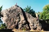 |
The Rock of Jana - Toma is claiming itself to be the highest (almost 8 m) rock in The Baltic. It is located in Kasispea village. |
|
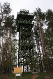 |
Viens no diviem nacionālā parka skatu torņiem, kas atrodas ~ 1,5 km ziemeļos no Ehijerva ezera (Ähijärv). Tornis ir veiksmīgi „nomaskēts” nelielā priežu pudurī, tādēļ tas „nebojā” izcilo dabas un kultūrainavu, kas paveras no tā skatu platformas. Pie autostāvlaukuma ir izveidota labiekārtota atpūtas vieta. |
|
 |
There are three craters here, and the biggest one, known locally as Põrguhaud, or Grave of Hell, has a diameter of 80 m and a depth of up to 12 m. There are barriers around the crater that are several metres high. The other two craters are hard to spot. The craters around 6,000 years old. No scraps of the supposed meteorite have been found, however, and so the origins of the craters cannot be confirmed with certainty.
|
|
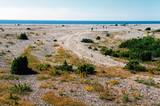 |
This is a “peripheral” island in the Bay of Finland, 9 km from the Dirhami port. The special fact about this island is that it offers fields of juniper, a rocky and grassy seashore that is around 2 km long, and limestone cliffs that are a few metres high along the northern and the eastern shores of the island. These are designated with the words Osmussaare pank.
|
|
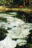 |
Three little lakes can be found on the left bank of the Pirita River with many erupting “eyes” of streams, each with its own colour (bluish-green, white, dark). This puts together various colour combinations. These are often known as the most beautiful streams in Estonia. Some pump out as much as 20-30 litres of water per hour. It is said that the waters are good medical resources, particularly for the eyes. There are improvements in the area of tourists.
|
|
 |
Litorīnas jūras laikā (pirms ~ 6000 gadiem) Saleveres Salumegi kalns bija sala, bet mūsdienās tas kā izteikta kāple (īpaši - ziemeļu pusē) paceļas virs Piejūras līdzenuma. Salumegi ziemeļu pusē slejas 4 - 5 metrus augsts kaļķakmens atsegums – silūra perioda (> 400 mlj. gadu) koraļļu rifa paliekas, kuru noskalojuši Litorīnas jūras viļņi. Atseguma piekājē izplūst Acu avots, kam piedēvē dziednieciskas īpašības. Salumegi apskates nolūkos izveidota lokveida taka (1,5 km). No kalna augšas paveras labs skats uz Matsalu līci. Šeit atradies arī sens pilskalns. |
|
 |
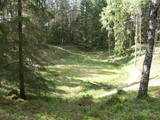
This is the most visually impressive drumlin field in the Baltic States, and it is close to the village of Tabivere. The drumlins were established by ice glaciers, and they point in the direction in which the ice moved long ago. In terms of their appearance, the drumlins resemble loaf-shaped hillocks. From their “backs,” there are lovely views of the local landscape and the lakes that are around the area. The visitor centre is in the village of Äksi.
|
|
|
|
This is the 11th largest Estonian island, and its central section is covered by a broadleaf forest (linden, oak, elm and other trees) that is more than 100 years old. Along the shores, the Abruka Island has meadows and small areas of wetlands. Only the northern part of the island is populated. Few tourists come to call, which means that the island is relatively untouched by humankind.
|
|
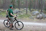 |
Eine von Nadelbaumwäldern bedeckte Halbinsel. Malerisches Käsmu Steinfeld, Matsikivi Stein, Vana Jüri Stein u.a. Bei passenden Bedingungen kann man sich auf einer steinernen Landzunge bis zur 0,5 km entfernt liegenden Insel Saartneem schleppen. |
|
|
|
Pamatīgs trīsstāvu koka tornis, no kura atklājas viens no labākajiem Matsalu līča un tā apkaimes palieņu pļavu skatiem, kuras apsaimnieko mājlopi, veidodami piemērotu vidi dažādām putnu un augu sugām. Laba migrējošo zosveidīgo putnu vērošanas vieta. Tā kā tornis ietilpst Tūlingu (Tuulingu) saimniecības teritorijā – spēkrats ir jāatstāj netālu esošajā autostāvlaukumā, bet suņi jāved piesieti kakla siksnā. |
|
 |
Cultural space of Kihnu (www.kultuuriruum.ee) is incorporated in the UNESCO list of Masterpieces of Oral and Intangible Heritage of Humanity, and is a quaint mix of old and modern. The local history museum displays tools, clothes, handicraft and furniture. |
|
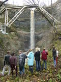 |
This is a cliff with various levels. Known as the North Estonian cliff, it stretches all along the shore of the Bay of Rīga in Estonia, including some of the local islands. The most expressive part in geological and landscape terms is the Saka-Ontika-Toila cliff, which is around 22 km long and offers an unusual natural environment. The cliff is as much as 53 m high, and it has a fairly virginal forest along its slopes. The layers of clay, sandstone, limestone, etc., come from the Cambrian and Ordovician periods. The Valaste juga (Valaste waterfall) is 24 metres high. After a longer period of freezing temperatures, the waterfall has a particularly impressive appearance. Seasonal waterfalls (8-10 m) can be found near the villages of Ontika and Toila.
|
|


