
Nature objects in Estonia

What's special about the nature in Estonia?
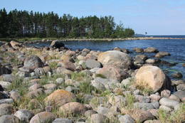
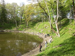
In Estonia, there stands the most impressive rock wall in the Baltics - the so called North Estonian "glint" (from Estonian language). Estonia has its own "Land of Inlets" - the Lahemaa region with its national park, the "Land of Islands" - the Saaremaa island and the Monzund archipelago. The Matsalu bay is one of the most significant rest stops for birds during their migration. In Estonia there is one of the most prominent impact craters in Europe, there are the greatest waterfalls and boulders in the Baltics, the Munamagi hill - the highest spot in the Baltics, the Lake Peipus - the 5th largest lake in Europe, - with long-standing fishing traditions, and the great variety of nature from West to East, from North to South.
Act responsibly - follow the Green advice!
| Overview | Details |
|---|---|
 |
Estonia
Perajerva meza taka (Pärajärve metsarada)Četrus kilometrus gara marķēta lokveida taka, kas ved pa lielāku meža masīvu, iepazīstina ne tikai ar augiem un dzīvniekiem, bet arī mežsaimniecības tradīcijām. Takas sākums atrodas pie nelielā Perejerves ciema, uz kuru paveras labs skats no tuvējā paugura. Pie autostāvlaukuma izveidota atpūtas un piknika vieta. |
 |
Estonia
Leti tornis (Läti torn)Jēsū – Kepu ceļa malā pie Leti (Läti) ciema ir izveidots autostāvlaukums ar putnu vērošanas torni, no kura paveras skats uz Hallistes upes palieņu pļavām un tuvējā ciema apkārtni. Stipru palu laikā arī no šī torņa redzamā apkārtne (izņemot ceļus) var atrasties zem ūdens. Laba putnu vērošanas vieta. Läti tulkojumā no igauņu valodas nozīmē Latvija. |
 |
Estonia
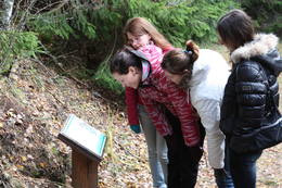
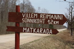
Paunas taka (Pauna rada)Kultūrvēsturiska taka (garums ~ 2 km) Tipu (Tipu) ciemā, kas iepazīstina ar vairākiem interesantiem objektiem: veco skolu (1931. g.), Hallistes upi, pirti un Paunas saimniecību, kurā dzimis viens no Igaunijas nacionālās kustības līderiem Villems Reimans (1861. – 1917.). |
 |
Estonia
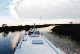
The Lahemaa National ParkThis is the first national park in Estonia and the Baltic States. Perfect for a day trip out from Tallinn for a hiking trip and nature watching. It was established in 1971 to protect the area that is along the Bay of Finland – the shoreline, forests, swamps, meadow biotopes, species, natural monuments, rocks, waterfalls, cliffs and cultural monuments such as ancient cemeteries, castle hills, baronial estates, fishing villages, etc. Services
50km - Distance from countries capital cityServices - recreational
Cross-country skiingFor cross-country skiers, the Käsmu peninsula is perfect during the season. 
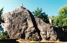
Bicycle trailFor bikers, there’s the Käsmu peninsula (~10 km), the route Loksa-Pärispea-Viinistu-Kasispea on the Pärispea peninsula (here you will find the highest rock in the Baltic States – the Jaani-Tooma rock (kivi, 7.8 metres high). 
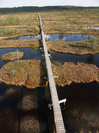
Nature trailYou can hike a wooden train over the Viru swamp (Viru raba, 3.5 km), another trail on the Käsmu peninsula (~15 km), and the Pikanõmme-Majakivi trail (4.5 km), along which you will find the third largest rock in the Baltic States – the so-called House Rock (Majakivi), which has a size of 584 m3. We also suggest the informational Altja trail (3 km). 
Nature watchingThere are viewing towers in the Viru raba swamp and along the Piaknõmme-Majakivi trail. There is a visitor centre at Palmse. |
 |
Estonia
Metsamoori (Woods Crone) Family ParkThis park is a network of farms in Kaika area where visitors can learn about healthy life styles and alternative medicine. Farms have programmes on using herbs and leech in therapies, on the magical worlds of bees and mushrooms, spells and meditation. In workshops you can learn to use weeds in cooking, make bread and herbal drugs. Individual travellers are welcome to explore the farm on their own. 275
 5-9 5-9
Services
275km - Distance from countries capital city
5-9 Active season months |
 |
Estonia
Felsen PakriDie mächtigste Steilküste im Baltikum (bis zu 24 m hoch). In den kalten Winter werden hier phantastische Gletscherstürze entstanden. Pakri Leuchtturm. 50
Services
50km - Distance from countries capital city |
 |
Estonia
The Rock of Jana - TomaThe Rock of Jana - Toma is claiming itself to be the highest (almost 8 m) rock in The Baltic. It is located in Kasispea village. 72
Services
72km - Distance from countries capital city |
 |
Estonia
Naissaar islandNaissaar is a small island near Tallinn which was exclusively used by the Soviet military from 1945 to 1993. Attractions on the island include walking trails, varied habitats, a narrow-gauge railway, fortifications from the early 20th C, and a Soviet naval mines factory. 12
1-12
Services
12km - Distance from countries capital city
1-12 Active season months |
 |
Estonia
Kihnu islandCultural space of Kihnu (www.kultuuriruum.ee) is incorporated in the UNESCO list of Masterpieces of Oral and Intangible Heritage of Humanity, and is a quaint mix of old and modern. The local history museum displays tools, clothes, handicraft and furniture. 180
1-12
Services
180km - Distance from countries capital city
1-12 Active season months |
 |
Estonia
Kaali meteorite cratersThis is actually a group of nine craters, and some of them are as much as 100 m in diameter and 16 m in depth. This is the most visually expressive meteorite crater in the Baltic States and, indeed, in all of Europe. Remnants of the meteorite – some 2.5 kg in all – yielded iron and nickel. It is thought that this pan-Baltic natural catastrophe occurred 2,600 to 4,000 years ago. Kaali Visitor Centre comprises the meteoritics and limestone museum, a conference hall and a hotel.The museum exhibits genuine meteorite pieces amongst other items. The hotel has all modern conveniences, tasty food is provided at Kaali Tavern nearby. 204
1-12
Services
204km - Distance from countries capital city
1-12 Active season months |
 |
Estonia
Rebases ainavu taka (Rebäse maastikurada)Ap 7 km garš lokveida pārgājienu maršruts (marķēts), kas ved pa dažādiem biotopiem – mežiem, mitrājiem un pļavām, mezdams līkumus pa stāvo pauguru nogāzēm. Takas malās ir izvietoti informācijas stendi un norādes. Rebases ainavu taka ir domāta tiem, kurus nebaida garāka iešana un orientēšanās pa ļoti dabisku un mazapdzīvotu apvidu. |
 |
Estonia
Skats uz Vaikas salam (Vaika saared)No Vilsandi bākas un tai tuvākās apkaimes ir labi saskatāmas leģendārās Vaikas salas. Tām ir piešķirts rezervāta statuss, tādēļ salas var apskatīt tikai no attāluma. Mazākā no saliņām - Kullipank ir tikai pārdesmit metrus diametrā. Tā ir jūras ūdeņu izrobots zemas un asas dolomīta klints fragments, kas klāts ar oļiem, nelieliem laukakmeņiem un kādu atsevišķi stāvošu lakstaugu. Domājams, ka vētru laikā tā pazūd zem jūras ūdens. Savukārt, Alumine Vaigas – Apakšējā Vaikas sala ir lielākā no sešām salām. Šīs salas diametrs ir ~ 150 m un tā paceļas vismaz kādus divus metrus virs jūras līmeņa. Uz salas ir bagātīga veģetācija un pat kāds zems krūms salas centrā. Redzami arī metru augsti atsegumi. Uz salas vēl joprojām atrodas 20. gs. sākumā celto „putnu māju” paliekas, kas bija domātas ligzdojošo putnu piesaistīšanai. |
 |
Estonia
Tartu-PiirissaareThis is a quick boat ride from Tartu down the Emajõgi River to Piirissaare Island in Lake Peipsi (Peipsi järv). Along the lower reaches of the river are major wetlands which are of enormous importance for birds.
ServicesServices - recreational
Boat tourTake the ship from Tartu to Piirissaare (65 km) and just enjoy the landscapes along the banks of the river.
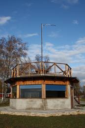
Nature watchingThere is a viewing tower on Piirissaare Island. For more information: www.visittartu.com (available in English). |
 |
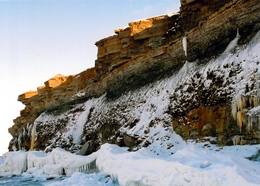
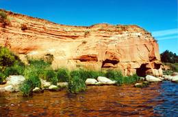
Estonia
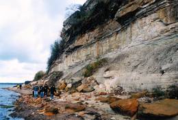
Turisalu cliffThis cliff is made of sandstone (its lower part) and limestone (the upper part). It is up to 30 m high, and it is part of the Northern Estonian set of cliffs along the shore of the Bay of Finland. This is a popular tourism destination and viewing location. Recommended Hike along the bottom of the cliff (a rocky beach) in one direction, and then along the top of the cliff to get back (~2 km). From the top of the cliff, you can see a broad segment of the shoreline territory, all the way to Tallinn.
|
 |
Estonia
Tuhala Nature Centre and NõiakaevTuhala region has settlements of about 3000 years of age. There are 11 ancient settlement sites, 30 cult stones, 3 burial sites, 4 sacred groves, etc. Tuhala Landscape Reserve has a unique natural feature - the Nõiakaev (Witch´s Well) which “boils” up water during floods at 100 l/s, and 5 mightiest energy columns of the country. 32
1-12
Services
32km - Distance from countries capital city
1-12 Active season months |
 |
Estonia
Sõrve säärDie Südspitze der Insel Saaremaa – eine aus Geröll in der Irbenstraße langgestreckte Landzunge. Militärbefestigungen, Leuchtturm (1960), Vogelbeobachtungsort. 270
Services
270km - Distance from countries capital city |
 |
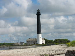
Estonia
Kap TahkunaDer weiteste Nordpunkt der Insel Hiiumaa. Der höchste Leuchtturm Estlands aus Roheisen (1873 – 1875) und das Denkmal zur Errinerung an die bei dem Unglück des Schiffes ‘Estonia” Umgekommenen. 175
Services
175km - Distance from countries capital city |
 |
Estonia
Saaremaa IslandThe biggest sea island in Estonia. In translation - "Land of The Islands". A bridge, where cyclists can drive connects Saaremaa island to Muhu island . 160
Services
160km - Distance from countries capital city |
 |
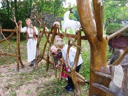
Estonia
Viking villageA unique theme park on the River Pirita evokes interest in ancient Vikings. Facilities include: stronghold, chamber of spells, smithy, Viking boat and dugout canoe trips, shows and battles with ancient weapons, a catapult, archery, axe throwing, cave and smoke saunas, trout fishing, accommodation, catering etc.  30
1-12
30
1-12
Services
30km - Distance from countries capital city
1-12 Active season months |
 |
Estonia
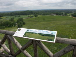
The Karula National ParkThis park is in a region of hillocks in the Karula highlands, and Lake Ähijärve is at its centre. The park offers a cultural environment of small farms, and it was set up to protect the unique cupola-shaped hillocks of the area. Main attractions: Scenic Lake Ähijärv (176ha), Rebasemõisa Tornimägi hill (137.8 m above sea level), undulating landscapes. Services
280km - Distance from countries capital cityServices - recreational
Fishing
Bicycle trailBike the route Ähijärve-Peräjärve-Kolski-Rebasemõisa-Kaika-Ähijärve (26 km).
Nature trailHike the Ähijärve nature trail (3.5 km), the Rebase landscape trail (7 km), or the Peräjärve nature trail (4 km).
Nature watchingThere are viewing towers on Tornimägi hill and at Mäekonnu. The visitor centre is in the village of Ähijärve. For more information: www.karularahvuspark.ee (available in English). |
 |
Estonia
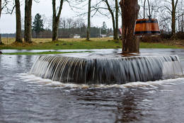
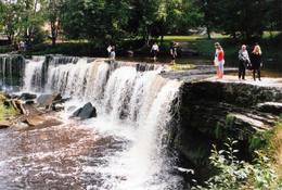
Keila waterfallThis is one of the loveliest waterfalls in Estonia – up to 6 m in height and 50 m in width. Recommended: The rapid Keila River has carved a cliffy canyon behind the waterfall, with a flow of water that falls down a major distance. It’s worth hiking through the Keila park to the shore of the Bay of Finland (~1 km), then returning along the other bank of the river.
Services
31km - Distance from countries capital cityServices - recreational
Nature trailThe rapid Keila River has carved a cliffy canyon behind the waterfall, with a flow of water that falls down a major distance. It’s worth hiking through the Keila park to the shore of the Bay of Finland (~1 km), then returning along the other bank of the river. |
 |
Estonia
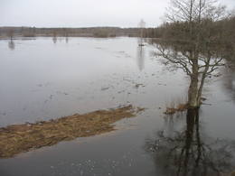
Penije tornis (Penijõe torn)Lai nokļūtu līdz šim tornim, ir jāveic apmēram 20 – 30 min ilgs pārgājiens pa dabas taku no Penijē muižas gar Penijegi (Penijõgi) kreiso krastu. Te redzami bebru darbi un to celtās zaru mājas. No torņa paveras skats uz Kazari deltu, kas dabā izpaužas kā monolīts un nepārskatāms niedrājs. To vairākās daļās sadala Kazari un mazāka izmēra upītes. Katrai deltas daļai ir savs vēsturiskais nosaukums: no torņa pa kreisi no Penijegi redzama Lihula meri (Lihulas „jūra”), bet tās labajā pusē - Kloostri meri (Klostri „jūra”). Putnu vērotāji var iziet garāku (7 km) dabas takas loku, kas ved pa palieņu pļavām. Jārēķinās, ka pavasaros būs nepieciešami piemēroti apavi! Pļavas ierobežotās platībās apsaimnieko mājdzīvnieki, tādēļ neaizmirstiet aizvērt vārtiņus aiz sevis un netraucējiet to ikdienas gaitas! No maršruta nav atļauts novirzīties, lai netraucētu putnus. |
 |
Estonia
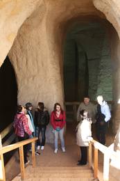
Ancient Piusa River valley and Piusa caveThe area of the ancient Piusa River valley that is between the villages of Vana-Vastseliina and Ignasõ is around 15 km long, features some substantial rapids, and offers a view of beautiful Devonian period cliffs. The largest, Härma müür, is 43 metres high and is the highest sandstone cliff in Estonia. There are caves from old mines in the village of Piusa. A small part of the mines, which have tunnels that are more than 10 km long in all, has been tured into a local museum.
ServicesServices - recreational
Boat tourBoat from Vana-Vastseliina to Ignasõ (1 day, extreme boating, only during flood season). For more information: www.piusa.ee (available in English).
Nature trailHike down the river valley along its entire length (~20 km). |
 |
Estonia
The sandstone cliffs of KallasteThis is one of the few places in the Baltic States where one can find Devonian period sandstone cliffs featuring abrasion caves, arches, etc. The cliffs are on the shores of Lake Peipsi (Peipsi järv), near Kallaste, and they are between two and four (in some cases – nine) metres high, stretching for a distance of around one km.
ServicesServices - recreational
Nature trailHike along the shores of the lake to and from the cliffs (3 km).
Nature watchingThere is a viewing tower which offers a good look at Lake Peipsi and the shoreline. For more information: www.kallaste.ee (only in Estonian). |
 |
Estonia
Kidevas (Kiideva) putnu verosanas platformasPirmā ir uzcelta uz vienstāvīgā apmeklētāju centra jumta. No tās paveras plašs skats uz Kīdevas ciemu, ostu un niedrēm apaugušo Matsalu līča ziemeļdaļu. Austrumos no šīs atrodas vēl viena - divstāvīga putnu vērošanas platforma. No Kīdevas līdz Puisei gar Matsalu līča var doties pārgājienā pa 5 km garo dabas taku. To izejot, novēroto putnu sugu klāsts noteikti būs lielāks! |
 |
Estonia
The blue streams of SaulaThree little lakes can be found on the left bank of the Pirita River with many erupting “eyes” of streams, each with its own colour (bluish-green, white, dark). This puts together various colour combinations. These are often known as the most beautiful streams in Estonia. Some pump out as much as 20-30 litres of water per hour. It is said that the waters are good medical resources, particularly for the eyes. There are improvements in the area of tourists.
|
 |
Estonia
The Endla ReserveThis reserve was set up to protect local swamps and surrounding wetlands. Please note that before you can visit the reserve, you must register with the local administration and visitor centre in the village of Tooma.
ServicesServices - recreational
Nature trailThe Endla swamp trail (~2 km) with a viewing tower, and the Endla stream trail (6 km). Please note that before you can visit the reserve, you must register with the local administration and visitor centre in the village of Tooma. For more information: www.endlakaitseala.ee (available in English). |
 |
Estonia
The Viidumäe ReserveThis reserve dates back to Lake Ancilus, which was one of the original elements of what is now the Baltic Sea. The lake’s ancient shores feature wetlands, forests and flora which are all protected by the reserve.
Services
244km - Distance from countries capital cityServices - recreational
Nature trailThe Viidumäe educational trail (1.2 km), the Audaku hiking trial (2.8 km).
Nature watchingThere is a viewing tower on Mount Viidumägi with a broad view of the western end of the Saaremaa Island. It’s worth visiting the visitor centre at Audaku. |
 |
Estonia
Putnu verosanas tornis Puises ragaPuises ragā (Puise nina) ir uzcelts divstāvīgs atpūtas nams, kas apvienots ar putnu vērošanas torni. No tā paveras skats uz piekrasti, kas ir iecienīta migrējošo zosu atpūtas vieta. Šī ir privāta teritorija, kuras apskati vēlams saskaņot ar īpašnieku. 123
Services
123km - Distance from countries capital city |
|
|
Estonia
Klostri (Kloostri) skatu tornisMetāla tornis Kazari upes kreisajā krastā, ~ 5 km attālumā no Matsalu līča. No torņa redzamās Kazari deltas palieņu pļavas atrodas tikai 0,3 – 1 m augstumā virs jūras līmeņa, tādēļ pavasara palos un stipru vētru (īpaši rietumvēju) laikā ūdens appludina milzīgu teritoriju. Uzskata, ka platības ziņā šīs ir vienas no lielākajām Eiropas palieņu pļavām, kas ir nozīmīga dažādu tārtiņveidīgo putnu sugu ligzdošanas, dzērvju un zosveidīgo putnu atpūtas un barošanās vieta. Ir pagājis laiks, kad zemnieki Matsalu pļavās ganīja govis un pļāva sienu, tādēļ šobrīd pļavu apsaimniekošanu veic nacionālā parka administrācija. |


