
| Nr | Name | Beschreibung |
|---|---|---|
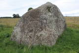 |
Atrodas 4,5 km ziemeļos no Rīgas – Daugavpils šosejas (A 6), klajā laukā (ap 3 m augsts, ainavisks). Viens no izcilākajiem Latvijas muldakmeņiem, tādēļ ir vērts izmest kādu loku. Akmens augšdaļā ir iekalts gandrīz 2 m garš un ~ 20 cm dziļš muldveida iedobums. Atrodamas ziņas, ka vēl 19. gs. vidū pie akmens ir ziedots ēdiens, monētas u.c. priekšmeti. Pie tā dedzināti ugunskuri un svinēti svētki. Teikas vēsta, ka velns muldā lējis ūdeni un gribējis mīcīt mīklu, kā arī parāvis zem akmens tuvējo māju saimnieku. |
|
 |
The Boulder of Labvārži is located in the Northern side of Adamova Nature Park, in the SW of Lake
Vizulītis (Labvārži). It is located 0,70 km from the Labvārži or Laboržu House. The boulder is 5.9m long and
4,0 m wide.
|
|
 |
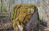
Auf dem Stein stand früher (heutzutage nicht
mehr zu sehen) eine Aufschrift, die besagte, dass die Liven vom schwedischen König
Karl IX und der Pest besiegt wurden. Vor Kurzem wurde noch ein Stein (der kleinere)
draufgestellt, der eine Zeit bei dem Haus Pakalni stand und dessen Aufschrift auch
verblichen ist. Die Steine befinden sich auf einer Grabstelle der Opfer der Pest.
|
|
 |
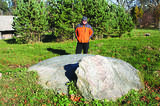
The Boulder of Subinaite can be found in Sakstagala rural municipality opposite Vaļenieku House that
is on the left side of the river Rēzekne. The base of the boulder is below the river level; it is 5,2 m long, 4,4
m wide, it rises about 1,6 m above the water level, about 2,5 m below the water level, capacity 26 m3.
Reddish surface is heavily eroded and full of moss. Protected since 1977.
|
|
 |
Im Wald von Kaltene ist ein sagenumwobenes Naturwunder – Kalvas von Kaltene bzw. von Valna zu besichtigen. Das Entstehen dieser Anhäufung im Wald, 2 – 3 km von der Küste entfernt ist mit den Küstenbildungen des Baltischen Eissees verbunden. Die größte Anhäufung ist Velna kalva (Teufels-Kalva). Seinerzeit war Velna kalva eine schöne Anhäufung, so große, dass “sich bis Gipfeln der Bäume streckte”. Auf den früheren Karten wurde die absolute Höhe dieser Anhäufung angegeben – 20 m. Diese Anhäufung bestand aus Steinen verschiedener Formen. Die Steine waren sowohl voll kugelförmig als auch in einer Tellerform. Diese Anhäufung wurde fast vollständig in den 1960er – 1970er Jahren vernichtet, da daraus die Schotter für Straßenbau gewonnen wurde. Heutzutage ist nur ein ziemlich kleines Fragment des Unterteils von Kalva erhalten geblieben. Die Länge dieses Fragments beträgt ca. 300 m, aber die Höhe – 2 m. Die Wissenschaftler äußern eine Meinung, dass diese Anhäufungen im Altertum Sakralorte sein könnten, da viele Sagen und Legenden sind darüber geblieben. Um die Anhäufung zu besichtigen, wurde einen Naturpfad mit den Informationsständen und einem nicht großen Parkplatz errichtet. (Die Quelle: Roja TIZ) |
|
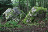 |
Ziemeļos no Viļāniem (Jaunviļānos) atrodas ar mežu apaudzis osveidīgs paugurs – t.s. Kaupra kalns, kurā virsotnē meklējams (ceļa uz Trūpiem malā izvietota norāde) minētais akmens. Trīsdaļīgā akmens, kas atrodas mežā, garums ir 4 m, platums 3 m, augstums 1,9 m. Lielākās daļas virspusē var saskatīt nelielu dobumu, tādēļ pastāv viedoklis, ka šis ir sens kultakmens. |
|
 |
Jaunstašuļi Devil's Footstone is situated in the village of Jaunstašuļi in overgrown place beside the
derelict houses. It is hard to find it without the guide. The boulder is 0,75 m high and its circuit is 5,85 m.
On the surface there is the human foot: the length 0,3 m, width 0,09 m, depth 0,02. There was another foot.
It’s obviously scaled off. The North side of the boulder has three casted steps.
|
|
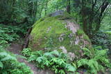 |
200 m attālumā no Gulbenes – Madonas ceļa mežainā nogāzē iegūlis 2,4 m augstais akmens. Tā lēzenajā virsmā iekalta ap metru gara, 0,3 m plata un ap 4 cm dziļa iedobe, bet akmens šķautnē - pakāpieni. Uzskata, ka šis ir sens kultakmens, pie kura ziedots. Lai nokļūtu līdz akmenim, vasaras otrajā pusē var nākties brist pa garu zāli. |
|
