
| Nr | Name | Beschreibung |
|---|---|---|
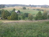 |
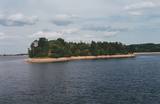
Dieses Territorium schützt die höchsten Erhebungen im Alūksne – Hochland, den Dēliņkalns – Berg, sowie seine Biotope an seinen Hängen. Die örtliche Landschaft ist auch geschützt. Es gibt hier Abfahrtsski – Routen und seine südliche Seite ist besonders reizvoll.
|
|
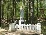 |
The castle hill of Milka is situated near Lake Sālaja and River Malta; 27m above the lake level. Local
businessman cleaned the hill and placed the statue of Mother of God there. It is a a symbol of Latgalian
strong faith into God and Virgin Mary.
|
|
 |
Krāču Hügel – eine Reihe von welligen Hügeln,
die sich während der Zeit vom Litorinischen Meer bei
starkem Wind gebildet haben. Von den Krāču Hügeln
ergibt sich ein wundervoller Blick auf den Liliensee.
Gegenüber vom See, am östlichen Teil der
genannten Straße, kommt man über Dolomitstufen
bis zum Denkmal für 90 lettische Schützen die 1 91 7
in Kämpfen gefallen sind.
|
|
 |
Arī Senču pilskalns, Baznīckalns un Velna gulta. Pirmo reizi minēts 1230. gadā kā viens no senās kuršu zemes Vanemas centriem. Ar šo objektu var sākt Abavas senlejas skaistāko skatu apzināšanu. Līdz pilskalna plakumam ved kāpnes, un no tā redzami senlejas vārti un upes ielejas kreisā krasta nogāze, kuras piekājē izvietojusies Jaunkandava.
|
|
 |
Before its flooding, the canyon of the Daugava River between Pļaviņas and Koknese was one of the most outstanding and beautiful parts of the Baltic terrain, and Oliņkalns hill was one of the largest castle hills in Latvia. The Andrejs cliff as up to 20 metres high, and it was part of the Daugava canyon. Before the area was flooded because of the construction of the Pļaviņas hydroelectric power plant, there were rapids near the hill that made it hard for rafters to sail down the river. Today it is a small island in the reservoir of the plant (it can be seen from the side of the Rīga-Daugavpils highway (A6) opposite Stukmaņi). It is separated from the shore by 300 metres of river, under which the Dūņas valley is now resting. A small part of the ramparts of the castle hill can still be seen on the island along with the ruins of an open-air stage and a few metres of the dolomite cliff that have remained above water. It is thought that the Alene castle was on the hill in the 13th century. Latvian mountain climbers installed a memorial stone in 1998 opposite Oliņkalns hill. |
|
 |
Одна из наиболее высоких дюн нашего побережья. В советское время в дюне велись копательные работы, так как песок использовался для производства силикатного кирпича. В 80-е годы ХХ века копательные работы были прекращены. Самая высокая часть дюны (хороший вид) сохранилась и поросла сосновым лесом. Создана природная тропа горы Пусену. Находятся в Бернатском природном парке. |
|
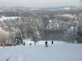 |
Der Gaiziņkalns ist der höchste Berg in Lettland und ist ein typisches Beispiel für die Hügel des Vidzemer Hochlandes. Dies ist ein Platz mit einer wunderschönen Landschaft, wenn es dort auch nicht so viele schöne Aussichtsplätze gibt. Im Zentrum des Parks befindet sich der Gaiziņkalns-Berg – die höchste Erhebung Lettlands und die zweithöchste der Baltischen Staaten (311,6 m über dem Meeresspiegel). Der Aussichtsturm ist wegen seines schlechten Zustandes leider nicht freigegeben für die Öffentlichkeit. Es gibt einen gut markierten Wanderweg um den Gaiziņkalns herum und während des Winters sind der Berg und seine Umgebung beliebt als Abfahrts- und Langlauf - Skigebiet. Der See Viešūrs (See Kaķītis) ist bei amtlich zugelassenen Fischern beliebt. Dieses Gebiet ist Teil einer Region geschützter Landschaften um Vestiena herum.
|
|
 |
Kirkas Hill in Micāni. In 1792, a small castle on the hill Priežukalns (Kirkas kalns) was rebuilt into
Lutheran Church. Nowadays, the hill still is called Kirkas kalns (in German „Kirche” means „church”).
Old people say – under the church there is a big cellar where the jewellery of church and the Mantefel
family is hidden; Manteifel family vault is there too.
|
|
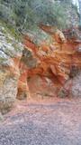 |
Sarkanās klintis savu vārdu ieguvušas pateicoties sarkanajiem iežiem. Tieši sarkanā ir mīlestības krāsa, tāpēc sarkanās klintis ir romatiska pastaigas vieta mīlniekiem. Smilšakmens klintīs redzamas plaisas, kas sašķeļ sarkanīgos iežus, radot neparastu dabas mākslas darbu. To virsma ir diezgan izrobota, kas veido klintīs nelielas alas un nišas. Sarkanajās klintīs ir arī daudz dažādu avotiņu. Pazīstamākais no tiem ir Rūcamavots. Tam ir šāds nosaukums, jo tas, nākot ārā no zemes, izdod nelielu rūkoņu. |
|
 |
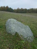
Karņicka kalns pēc savas izcelsmes nav kalns, bet gan Daugavas ielejas nogāzes daļa ar labu skatu uz Krāslavas mazstāvu koka apbūvi. Ar šo vietu saistīts traģisks nostāsts par poļu virsnieka Josifa Karņicka un grāfa Plātera meitas mīlestību, kurai nebija lemts piepildīties tā laika „paražu” dēļ. Tā rezultātā abi nelaimīgie nolemj izdarīt pašnāvību. Virsnieks nošaujas, bet Emīliju pēdējā brīdī izglābj kalpone, neļaujot tai izlēkt pa pils logu. J. Karņicka pašnāvības vietā ir uzstādīts piemineklis. Nedaudz tālāk – rietumu virzienā guļ t.s. Austriņa akmens, pie kura 1909. gadā iedvesmojies un radījis latviešu rakstnieks Antons Austriņš. |
|
 |
Eine der eindrucksvollen Reliefgestaltungen im Baltikum. Bei Sigulda erreicht das Urstromtal eine maximale Tiefe von 85 m ( Breite ung. 1 km). Schöne Sandsteinaufschlüsse aus dem Devon ist ein Anziehungspunkt. |
|
 |
Is an ancient Courlandian castle hill and is found in the very centre of Alsunga. It was named in 1659 when General Berg from Kurzeme put cannons on it to attack Swedish forces that had fortified themselves in the Alsunga castle. The hill is 8 to 10 metres high and 24 x 54 metres wide, offering a lovely view of the St Michael Roman Catholic Church, as well as the Alsunga windmill lake that is alongside it. There is a distinct terrace around the hill, and it once was the foundation of wooden defensive structures. On the other side of the street, to the West of the castle hill, is a cemetery with fire graves of Courlandians that date back to the 11th to 13th century. Archaeologists examined the area during the middle part of the last century. The Suiti celebrate Easter and other holidays on the hill. |
|
 |
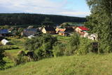
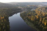
Dieser Naturpark ist der schönste und ausgeprägteste Teil der Nanema-Hügel in Nordkurzeme. Das Ziel ist, die Hügel von Talsi zu schützen. Es ist eine der reizvollsten Gegenden von Kurzeme mit kleinen, aber ausgeprägten Hügeln und Schluchten dazwischen. Es gibt kleine, aber ziehmlich tiefe Seen in diesem Gebiet – die Seen Ābeļi, Čumals, Sirdsezers usw. Einige von ihnen erinnern an tiefe Krater. Das Terrotorium eignet sich sehr gut für aktive Touristen – Wanderer (es gibt Naturpfade), Radfahrer usw.
|
|

