
| Nr | Name | Beschreibung |
|---|---|---|
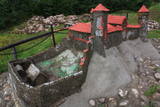 |
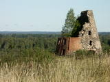
In diese konnte man über eine Zugbrücke gelangen, in dem man die äußere und die innere Vorburg durchquerte. Bis in die Mitte des 16. Jh. diente die Burg als Residenz des Komturs von Dünaburg. 1577 wurde sie vom Heer Iwans des Schrecklichen zerstört.Nach diesem Ereignis verlor Dünaburg seine strategische Bedeutung und der Bau eines Festungsbaus wurde dort begonnen, wo sich heute Daugavpils befindet. Neben der Ruine der Ordensburg befindet sich ein verkleinertes Modell der Burg, damit man sich vorstellen kann, wie es hier vor vielen Jahrhunderten ausgesehen hat. Vom Parkplatz bis zum Burghügel gelangt man über einen bequemen Pfad.Vom Burgberg hat man einen der schönsten Ausblicke auf den Naturpark der Daugavabiegungen. |
|
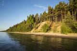 |
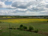
Die Steilküste von Ēvaži – bis zu der 8-15 Meter hohen Steilküste führt der 0,3
km lange Pfad, an dessen Ende man einen der schönsten kurländischen Anblicke
auf die Bucht von Riga hat.
|
|
 |
The Buse (Matkule) castle hill is near the Imula River. From the castle hill and from the opposite shore of the river, you can find one of the loveliest views of Kurzeme’s small rivers. Their appearance is best when trees and other flora are bare and the view is unimpeded. A wonderful view of the Imula valley is also seen on the road to the castle hill – near the Buse homestead.
|
|
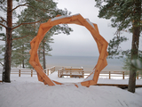 |
A new section of the walking trail along the sea has been built and an environmental object "Sunset watcher" has been created in Saulkrasti near the White Dune and Sunset Trail. It is a photo object where the newlyweds and every guest of Saulkrasti can capture memories in the symbol of the sun, which is so characteristic of Saulkrasti. |
|
|
|
Viena no augstākajām Latvijas celtnēm ar vienu no augstākajiem skatu laukumiem (65 m). Paveras izcila Vecrīgas un Rīgas ainava, kā arī Daugavas (līdz Rīgas HES dambim) un Pārdaugavas skati. Labi redzami blakus esošie Rīgas centrāltirgus paviljoni. |
|
 |
From the Asote castle hill, which is on the right bank of the Daugava River near Jēkabpils, there is a fine view of the Daugava River valley, the Ābeles Island, and the Kaupre castle hill that is at the northern end of the island.
|
|
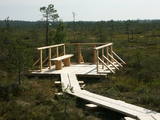 |
At the end of a wooden footpath in the Planči swamp is a viewing area and place for leisure. This is the place where you can enjoy landscapes of the high-type swamp and breathe the unusual air of the swamp. This is the only outdoor infrastructure object in Latvia with information posted in Braille. It is in the ZBR.
|
|
 |
Gar Grobiņas ūdenskrātuvi (Ālandes labais krasts) izveidota mūsdienīga un labiekārtota pastaigu un atpūtas vieta - promenāde, uz kuras izvietotas plāksnes ar Zentas Mauriņas un Jāņa Raiņa citātiem. No promenādes paveras labi skatu punkti uz Skābaržkalnu un Grobiņas pilsdrupām. Grobiņas ūdenskrātuves sašaurinājumā pāri Ālandei ved neliels tiltiņš, kas ir bijušā Liepājas – Aizputes šaursliežu dzelzceļa tilta ferma. |
|
 |
This is the highest point in the Latgale highlands (289 metres above sea level), opening up a narrow but lovely view of Lake Rāzna and the massive forests of the highlands. You really should visit this hill when the sun is setting beautifully!
|
|
 |
In Dagda, on the side of Daugavpils Street, there is a forested hillock that is the Lubāne castle hill. On the upper part of its southern side, there’s a viewing area which offers a view of the small Lake Lubenenis, the eastern part of Dagda, and the white tower of the local Catholic church. Legend has it that treasure is buried here.
|
|
 |
This is a view worth a journey from a distance. This is an impressive terrain for Latvia, and here you will see as far as the Hanja highlands of Estonia, where the Great Munameģis Hill – the highest surface in the Baltic States – can be found.
|
|
 |
In the centre of Līgatne, on the right bank on the rapid Līgatne River, there is a viewing plan which offers a close-up look at one of the most impressive sandstone cliffs which rise above it – the Lustūzis cliff. There are artificial caves in the wall of the cliff, which locals use as cellars and as places to store their property.
|
|
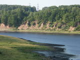 |
In Aizkraukle, drive down Enerģētiķu Street to the Selonian side (there will be small “pockets” at the side of the road) to see one of the best views of the Daugava River valley, reminding us of what this fateful river was like before the power plant was built. You will see that the river has eroded the steep cliffs on the right bank. The further part of the valley is part of the Daugava Nature Park.
|
|
 |
Beautiful views are accessible from the Sabile castle hill (steps, a location for relaxation), Upurkalns Hill (no improvements) and Briņķpedvāle, which part of the Pedvāle Open-Air Art Museum. There are also the Drubaži nature trails. The road between Kandava and Sabile which runs along the right bank of the Abava and the Aizdzire-Kalnmuiža road which runs on the left bank of the Abava also offer beautiful landscapes.
|
|
 |
Daugavas aizsargdambju būvniecību Jēkabpilī uzsāka pēc 1981. gada lielajiem paliem, kad ūdens līmenis pārsniedza kritisko - 6,3 m atzīmi un pakāpās līdz rādījumam „8,7 metri”. Šo plūdu laikā puse pilsētas klāja Daugavas ūdeņi. 2011. gada vasarā notika plašāki dambja atjaunošanas un labiekārtošanas darbi. Pie tā uzstādīja laternas, soliņus, izveidoja pastaigu promenādi un piemiņas zīmi Daugavas kreisajā krastā, kas parāda maksimālo plūdu līmeni. Uz aizsargdambja Daugavas labajā krastā ir izvietoti informatīvie stendi, kur var uzzināt daudz interesantus faktus par pilsētas vēsturi. Dambji ir piemērota vieta, kur fotografēt vai gleznot pilsētas ainavas. |
|
 |
The area known as the territory of high hillocks has several heights – Lakta Hill (250 metres above sea level), Egļu Hill (268 metres above sea level), and Bākūži Hill (272 metres above sea level). They are connected by an earthen road – it’s worth hiking the trail to find the best viewing areas. A very fine view of the backs of hillocks in the Vidzeme highlands can be seen from the northern side of Lakta Hill.
|
|
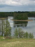 |
In Vecslabada, there is a peninsula among Lake Dziļezers, Lake Audzeļi, and Lake Istra. From the highest point on the peninsula, you will see a truly unusual view of the land of the blue lakes – lake islands, as well as the village of Vecslabada with its church towers. The Lake Istra nature reserve is nearby.
|
|
 |
Aptuveni 0,5 km dienvidos no Mežotnes pilskalna atrodas Vīna kalns, kas līdzīgi kā Mežotnes pilskalns, ir veidots, izmantojot Lielupes ielejas stāvās krastu nogāzes, tās pārveidojot. Vietvārds ir it kā radies no stāsta, ka šeit parādījies dievgalds ar maizi un vīnu. Vīna kalnu ar Mežotnes pilskalnu savieno jauka koka laipa, kas ved pa Lielupes ielejas pamatkrasta lejas daļu. |
|
