
| Nr | Name | Beschreibung |
|---|---|---|
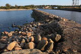 |
Molu (sākotnēji – pāļu rindas ar akmeņu krāvumiem) izbūve pie Sakas ietekas jūrā tika uzsākta 1878. gadā, lai nodrošinātu ostas darbību. 1929. gadā notiek molu pārbūve, pagarinot tos ar masīviem betona blokiem. Pēdējā rekonstrukcija notika 2010. gadā, pārveidojot molus par ērtu pastaigu un makšķerēšanas vietu, no kuras var vērot arī saulrietu. |
|
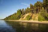 |
Die Steilküste von Ēvaži – bis zu der 8-15 Meter hohen Steilküste führt der 0,3
km lange Pfad, an dessen Ende man einen der schönsten kurländischen Anblicke
auf die Bucht von Riga hat.
|
|
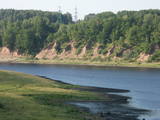 |
In Aizkraukle, drive down Enerģētiķu Street to the Selonian side (there will be small “pockets” at the side of the road) to see one of the best views of the Daugava River valley, reminding us of what this fateful river was like before the power plant was built. You will see that the river has eroded the steep cliffs on the right bank. The further part of the valley is part of the Daugava Nature Park.
|
|
 |
Latvia’s highest hill is the second highest in the Baltic States, but alas, it has only a wrecked viewing tower, so you’ll have to look for the best views on your own. You’ll find some around the tower and the ski trails, particularly Large and Small Golgotha. It is worth hiking the Gaiziņkalns nature trail.
|
|
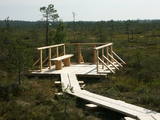 |
At the end of a wooden footpath in the Planči swamp is a viewing area and place for leisure. This is the place where you can enjoy landscapes of the high-type swamp and breathe the unusual air of the swamp. This is the only outdoor infrastructure object in Latvia with information posted in Braille. It is in the ZBR.
|
|
 |
This is not a well known castle hill, but it offers one of the most unusual views of Lake Lielezers of Augstroze. There are ruins on the castle hill, and a short hiking trail has been installed to look at them. This is part of the ZBR.
|
|
 |
This is the highest point in the Latgale highlands (289 metres above sea level), opening up a narrow but lovely view of Lake Rāzna and the massive forests of the highlands. You really should visit this hill when the sun is setting beautifully!
|
|
 |
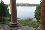
Von einem 60 m hohen Hügel eröffnet sich eine der schönsten lettgalischen Landschaften und ist der 2 km weit gelege Rāzna-See zu sehen. Die Ruinen der im 13 Jh. gebauten Burg. |
|
 |
From the Asote castle hill, which is on the right bank of the Daugava River near Jēkabpils, there is a fine view of the Daugava River valley, the Ābeles Island, and the Kaupre castle hill that is at the northern end of the island.
|
|
 |
The Ludza castle hill offers one of the most interesting views in Latgale – that of the oldest town in Latvia and its historical centre, Great Lake Ludza and Small Lake Ludza, the ruins of the castle of the Livonian Order, Baznīckalns hill, churches, the regional research museum, the craftsmen’s centre, etc.
|
|
 |
In Vecslabada, there is a peninsula among Lake Dziļezers, Lake Audzeļi, and Lake Istra. From the highest point on the peninsula, you will see a truly unusual view of the land of the blue lakes – lake islands, as well as the village of Vecslabada with its church towers. The Lake Istra nature reserve is nearby.
|
|
 |
Elka Hill is one of the highest surfaces in the western part of the Vidzeme highlands, and it offers a lovely and broad view to the North. There is a small parking lot, a TV and radio tower, and the place where the Gauja River is thought to originate.
|
|
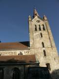 |
The tower of St John’s Lutheran Church in Cēsis, which is one of the oldest stone buildings in Vidzeme, offers a view of the historical centre of Cēsis, and a wide area all the way to Zilaiskalns Hill. There is also the western tower of the ruins of the Cēsis castle, one of the strongest fortresses of the Livonian Order in the Baltic region, and it offers a grand view of the castle’s park.
|
|
 |
These are beautiful and impressive views, particularly early in the morning, of the historical locations of Alūksne. Go to Templis Hill, the Aleksandrs Pavilion, the obelisk which commemorates Heinrich von Fittinghoff, and the memorial to soldiers of the No. 7 Sigulda Brigade for good views. The Templis Hill, the castle ruins, the estate and the pavilions are arhitectural monuments.
|
|
 |
The Northern breakwater of Liepāja is located n the Karosta area of the town. It offers a lovely place for perambulations, as well as an opportunity to observe the sea. To the South of the breakwater you will find a fine view of the Liepāja Freeport and its system of breakwaters. To the East is the unique Karosta area, while to the North, there are remnants of a sea fort. Please be very careful while observing the sea, however – the surface of the breakwater is not in great shape.
|
|
 |
In Dagda, on the side of Daugavpils Street, there is a forested hillock that is the Lubāne castle hill. On the upper part of its southern side, there’s a viewing area which offers a view of the small Lake Lubenenis, the eastern part of Dagda, and the white tower of the local Catholic church. Legend has it that treasure is buried here.
|
|
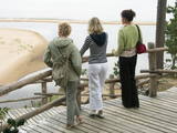 |
At the estuary of the Inčupe River, there is the White Dune, which is around 18 metres high and is the most lovely element of the Vidzeme shoreline among those that have been created by the wind, sand and sea. There is a wooden footpath (the Saulriets trail) which is meant to view, but also protect the dune. It has a viewing area, too. The territory to the south of the river is in the Piejūra Nature Park.
|
|
 |
The viewing area is near the top of the Vilce castle hill, with a view of the Rukūze River valley, Zaķi meadow, and surrounding forests. This is an unusual landscape for the region of Zemgale. The Vilce baronial estate is nearby.
|
|
 |
A beautiful part of the Rēzekne-Dagda-Krāslava road – along two km or so, you can see Lake Rāzna and Mākoņkalns hill, which is 10 km away on the other shore of the lake. |
|
 |
The area known as the territory of high hillocks has several heights – Lakta Hill (250 metres above sea level), Egļu Hill (268 metres above sea level), and Bākūži Hill (272 metres above sea level). They are connected by an earthen road – it’s worth hiking the trail to find the best viewing areas. A very fine view of the backs of hillocks in the Vidzeme highlands can be seen from the northern side of Lakta Hill.
|
|
