
| Нo | Название | Описание |
|---|---|---|
 |
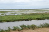
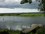
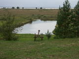
This is a short stretch of the Daugava River valley between Lielvārde and Dzelme, with islands and shallows in the river, as well as with reeds and wet meadows alongside it. During migration season, many goose-type and plover-type birds rest and feed here. The location is also an important nesting area for several other kinds of birds.
|
|
 |
This is one of the most impressive and extensive natural structures of its kind in Latvia in terms of appearance and landscape. The ice age left behind this wall-like terrain, which is up to 27 metres high and at the top of which the Rīga-Ērgļi road has been built. The Great Kangari hills offer a view of the Great Kangars lake and the Great Kangari swamps and ponds. The Ķoderi castle hill, also known as the “Big Man’s Bed” is found here. The restricted area was established to protect the structure and its related biotopes and plants.
|
|
 |
Nature restricted area is located to the South from former railroad Ventspils-Liepaja and includes approximately 6 km of Uzava River (and the old drainage system). The territory was used for agriculture during Soviet time, now it starts overgrow by scrubs. The protected nature values – rare bird species, including corncrakes, variety of grassland habitats and plant species. Territory is not useable for tourism activities. There is a possibility to get good insight into the North part of restricted area from the road Alsunga – Berzkalns where information stand is located.
|
|
 |
These are hillocks at the northern end of the Vidzeme highlands, and this is an important location for boreal (Northern) forests and swamps. Various kinds of swamps are found here, and the area is home to a variety of protected invertebrates.
|
|
 |
There is a small and relatively hard to reach area on the western shore of Lake Būšnieks which has been restricted to protect swamp habitats and several protected plants. Boat base is on the northern shore of the lake offers boat rental. From the plank-way good sites of eutrophic part of Lake Būšnieks can be seen. A well-appointed recreational facility (not included in the restricted area) is on the opposite shore of the lake. |
|
|
|
Atrodas Sedas purvā (Sedas dabas takas malā) ar plašu skatu uz izstrādātajām kūdras platībām. Sedas taku ieteicams izstaigāt vietējā gida pavadībā T: + 371 2636162. |
|
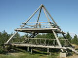 |
This is the only viewing platform of its kind. It is north of Pāvilosta, between the sea and Latvia’s largest gray dune. The second level of the platform offers a good view of the habitats which surround the dune, as well as the seashore and the largest seashore rock on the shores of the Baltic Sea – the Pāvilosta sea rock. You can also see the northern part of Pāvilosta. When it is windy outside, you’ll see kiteboard riders showing their tricks.
|
|
 |
Very wide territory for a nature restricted area where extensive forests and several bogs can be found. The territory is important living space for many bird species. Vasenieku bog path with observation tower is the most attractive sites of the restricted area and offers unique landscape of the bog for its visitors. Waterproof shoes are recommended for visitors as the first 500 m of the path is molded turf rampart. Information stands are significant source of information along the path. It is suggested to visit also Stikli (Glass) village where glass factory used to be. Chandelier of Stende church has been made in this factory (by memory of Inese Roze).
|
|
 |
Dabas liegums atrodas dienvidaustrumos no Lubāna ezera un tas veidots purva un meža biotopu un tajos esošo sugu aizsardzībai. Gar teritorijas ziemeļu robežu iet Nagļu - Degumnieku ceļš (iekļaujas kopējā Lubāna dambju sistēmā), pa kuru apkārt Lubāna ezeram izveidots velomaršruts. Tas nozīmē, ka teritoriju var aplūkot arī "no malas", netraucējot tās dabiskās norises. Teritorija ietilpst arī Lubāna mitrāja kompleksā.
|
|
 |
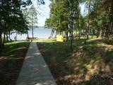
This is a large set of coastal meadows, ancient rivers and areas of reeds. It is found at a location where the Daugava River used to flow – between Vecmīlgrāvis and Vecāķi. There are inland dune meadows here, complete with the very rare silver grass. Vecdaugava is an important location for nesting birds and several uncommon plant species. On the southern end of the Vecdaugava peninsula, at a place called Skanstnieki, one can find remnants of medieval Swedish fortifications. The Vecdaugava Regional Research and Fishing Museum is here, as well.
|
|
 |
At the centre of this restricted area is the eutrophic Lake Tosmare, a former lagoon from the Littorina Sea. The lake and its surroundings offer protection to many plants and birds. At the southern end of the lake one can spot remnants of the former Liepāja fortification system, and to the West is one of the most important parts of that system – the Fortress canal. |
|
 |
Место, где можно отправиться на короткие и продолжительные прогулки. Здесь создана «Тропа Спридитиса» (с деревянными скульптурами героев сказки Анны Бригадере), протяженностью 1,6 км, «Учебная тропа лесных пейзажей», протяженностью 3,8 км и 8-ми км (в одном направлении) «Тропа пейзажей Аугшземе». Тропы расположены в субгляциальной ложбине, сформировавшейся от таяния ледника, где друг за другом разместились соединенные протоками несколько озерков и болотцев. В целях охраны пейзажей и других ценностей создан природный заповедник. В начале троп (недалеко от Пилскалне) стоит 30-метровый Мелнайскалнс (городище Рамава).
|
|
 |
The main “treasure” in this restricted area is the shallow and eutrophic lake, which is home to many important birds. The lake and its flood-land meadows also feature many different plants. The Svētupe River flows from the northern part of the lake.
|
|
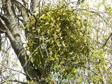 |
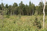
This is a mostly forested territory which is home to one of the largest areas of the white mistletoe, which is a semi-parasitic plant. It is best to observe this unique plant when it has no leaves. Latvia is the northern limit to the white mistletoe, which is why it is not all that common. It is interesting that even more of this rare specie can be seen outside of the nature restricted area. |
|
 |
Cena's heath swamp's trail was made to introduce vistors to one of the most beautiful things in nature - a moss swamp. The pathway goes not only around beautiful swamp lakes but also meets the degraded part of the swamp. At the beggining and the end is a watch tower. |
|
 |
The only island in Lake Ciecere has a more or less virgin forest of oak, linden and elm. Some of the oaks are huge. This is an important habitat for woodpecker-type birds. The island has not been improved. |
|
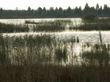 |
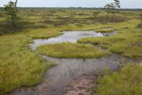
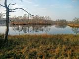
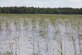
Peat moss has been extracted from the Seda heath since the middle of the last century, but it is nevertheless one of the most important NATURA 2000 territories in Latvia, with a great diversity of landscapes, biotopes and biology – birds in particular. This is a good place for bird-watching during migration season, and viewing towers have been set up on the edge of the swamp for this purpose.
|
|
 |
There is picnic area and information stand at the end of the forest path leading from Muiznieki to Klanu Bog. Klanu Lake was formed in the place of Littorina marine lagoon. Nature restricted area was established to protect biotopes in the area of Klanu, Dziru and Stavu Lakes. There is wide information about the area available on the information stand.
|
|
 |
Along with the Nagļu ponds, these are Latvia’s largest fishing ponds. They were established on the flood-land peat areas of Lake Lubāns in the 1970s, when the hydrotechnical system of the lake was first established. The Lubāna-Gaigalava road bisects the Kvāpāni-Īdeņa ponds. There are three bird-watching towers on the dams of the ponds. The ponds are a major location for water bird nests, as well as places for migrating birds to rest. There are extensive bird-watching opportunities in the area.
|
|
 |
Similar as Alsungas mezi (Alsunga forests) – is not intended and appropriate for visits. A narrow path of the restricted area can be seen from the gravel road – Saka-Apriki. Nature restricted area established mainly for protection of Erica tetralix (often called "cross-leaved heath") and it is one of the most important growing places.
|
|


