
| Нo | Название | Описание |
|---|---|---|
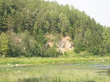 |
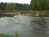
One of the most beautiful areas along the Venta River and its tributary, the Šķērvelis River. The river valleys and gullies along them are quite deep, and dolomite and sandstone cliffs can be spotted here and there. There are also rapids on the river. The largest cliffs in Kurzeme – the Ātraiskalns and Gobdziņi cliffs – can be seen on the banks of the Venta. The Lēni Catholic Church is near the restricted area. There are no tourist elements in the restricted territory at this time. The Venta is a popular destination for water tourists, however, from Nīgrande to Kuldīga. |
|
 |
Небольшая речушка, отличающаяся глубокой, но широкой долиной, которую пересекает дорога Вецумниеки – Илуксте. Название Вилкупе связано с амбициозным планом Курземского герцога Екаба о соединении бассейна рек Даугавы и Лиелупе. Работы, связанные с соединительным каналом, начались, но проект так и не был полностью воплощен в жизнь. В этом плане Вилкупе отводилась роль одной из составных частей канала. В этой связи стоит подумать о масштабе идей и творческих инновациях человека средневековья. Фрагмент канала отмечен и подлежит осмотру на расстоянии неполных 4 км от населенного пункта под названием Вилкупе. |
|
 |
The Slocene River flows through Lake Valgums and Lake Mazezers before flowing into the western part of Lake Kaņieris. It is part of a branched and swampy delta in which there are seasonal restrictions aimed at protecting birds. The wetlands which are alongside the river are difficult to access in many places. Before the Starpiņupīte was dug between Lake Kaņieris and the Bay of Rīga (the water level is regulated with sluices), the water from the river flowed along what is now the Vecslocene River all the way to Sloka, where it ended at the Lielupe River. The Vecslocene can be used by canoe boats only when the water level is high and then from the Old Ķemeri road to the place where the river enters the Lielupe. Between Milzkalne and Lake Valgums, the river is not navigable because of many fallen trees. During the springtime, the estuary of the Starpiņupīte is a good place for bird watching. |
|
 |
Старпиньупите – искусственно
выкопанное соединение между Каниерис и
Рижским заливом, где уровнем озера
сегодня управляет обновленная система
шлюзов. Хорошее место для наблюдения за
птицами в период весенней и осенней
миграции. Ориентир со стороны моря устье
реки Старпиньупите.
|
|
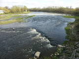 |
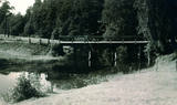
Above and below the town of Kuldīga, the Venta River is distinguished by a variety of biotopes – hillside forests, sandstone and dolomite cliffs, meadows, protected plants and animals, and diverse landscapes. There are popular tourism objects in this part of Kurzeme – the Venta dam, the stone bridge of Kuldīga, the Veckuldīga castle hill, etc. An ecological tourism trail runs along the banks of the Venta, and a bicycling trail has been installed on its left bank. |
|
 |
This is a territory that is unique at the Latvian and the Baltic level, one which stretches from Valmiera to the Gulbene District. Here we find the irregular Gauja River valley with a dense system of ancient rivers. The meadows on the banks of these rivers are important in terms of biological diversity. There are stands of oak and broad-leaf trees. Many rare and protected birds live and next here – the corn-crake, the woodpecker, etc. The territory is excellent for bird watching, nature studies, ecological tourism and various kinds of active tourism. |
|
 |
Каугурский канал вырыт в 1933 г. с
целью отвода вод рек Джуксте и Слампе в
Лиелупе для предотвращения
заболачивания
|
|
 |
Кишупе (длина 31 км) берет свое начало из болота Ледургской волости. На самом пляже Кишупе часто меняет русло и устье. Один из притоков Кишупе имеет интересное название – Пупалюрга. Название Кишупе, возможно, происходит от имени человека и названия дома. Поблизости от реки в 17 веке жил человек по имени Кисис. |
|
 |
Вершупите – улицу Броценю пересекает Вершупите,
которая петляет через город Кемери. Над водной
«пучиной» речушки переброшено 10 маленьких и
романтических мостиков. Каждый из них имел свое
название.
|
|
 |
The River Pēterupe (46 km long) in its lower reaches flows by the sea, and it is one of the longest parts of the river along the picturesque coastline. In the past the River Pēterupe had several names: Pērļupe, Tarupe, Tara (in Livonian: the River of God or the Holy River). The historic area of Saulkrasti – Pēterupe Village was located on the right bank of the River Pēterupe. |
|
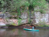 |
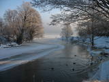
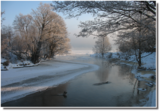
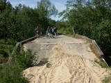
The Brasla River flows through a lovely valley that is approximately 300 m wide and up to 30 m deep. It is near the Inčukalns-Valka highway. The river has among the most beautiful rapids in the country, with mighty cliffs (the Brasla cliffs) that can be seen at nearly every curve in the river (except along the lowest reaches of the river). During the winter, various unusual frozen waterfalls can be seen in some of the cliffs, including the Krauļukalns cliff and the Jāņavārti cliff. On the left bank of the Brasla, opposite the Brasla fish farm, there are the Aņīte cliffs -- a series of sandstone cliffs that are 1 km long. The cliffs are between 2 and 35 m in height, and the sandstone cliffs are separated by ravines. On the right bank of the Brasla, there are major cliffs such as the Vāršavu cliff, the Kraukļukalns cliff, the Jāņavārti cliff, the Slūnu cliff, the Virtaka cliff and the Buļi cliff. How can you best learn about them? Boat down the river from the aforementioned highway or even from Straupe, which is further upstream. An alternative is hiking down the right bank of the river, though please take into account that the terrain is fairly extreme, and you are going to have to think about what to do when you arrive at the place where the Brasla River flows into the Gauja. |
|
 |
The nature park in the Ogre River valley is found along the middle section of the river. It has been established so as to protect the unregulated river valley and its surrounding territory, as well as biological diversity and habitats. For instance, this is an area in which rare park-type meadows can be found in Latvia. The Ogre is one of Latvia’s most popular rivers for water tourism in the spring, particularly downriver from the town of Ērgļi, where the technically complicated Braži rapids are found. |
|
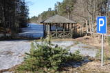 |
The Vecročupe river flows out of the artificial Vaide pond. It was created by blocking the Vaide and the Kukšupe rivers. This happened during the Soviet occupation, when forestry people decided to establish a fishing pond and an area for recreations. A wooden pergola has been installed at the pond, and there is an information stand, as well. On the northern shore of the pond is the Vaide cemetery, which dates back to 1928 and has interesting wooden crosses. |
