
| Нo | Название | Описание |
|---|---|---|
 |
This is the most visually impressive drumlin field in the Baltic States, and it is close to the village of Tabivere. The drumlins were established by ice glaciers, and they point in the direction in which the ice moved long ago. In terms of their appearance, the drumlins resemble loaf-shaped hillocks. From their “backs,” there are lovely views of the local landscape and the lakes that are around the area. The visitor centre is in the village of Äksi.
|
|
 |
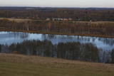
This park was set up to protect the landscape and cultural environment of the Haanja highland. At the central part of the park are the two highest hills in the Baltic States – Suur Munamägi, which stands 318 m above sea level, and Vällamägi, which is 304 m above sea level. The ancient Rõuge River valley (Rõuge ürgorg) is found in the western part of the park. It is 7.5 km long and up to 60 m deep. The valley dates back to the Ice Age, and it has seven lakes, including the deepest one (38 m) in Estonia – Lake Rõuge Suurjärv.
|
|
 |
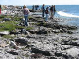
The word “Luitemaa” means “land of the dunes” in Estoninan. This coastline territory stretches for 13 km between Vöiste and Häädemeste with shallow waters, large coastal plains, Estonia’s highest dunes, and the Tokuse swamp (Tokuse raba). There are lots of birds here.
|
|
 |
Местность Тухала была заселена почти 3000 лет назад. Здесь 11 древних поселений, 30 культовых камней, 3 каменных могильника, 4 культовые рощи и т. д. В ландшафтном заказнике Тухала располагается и уникальный Ведьмин колодец, который во время большой воды «кипит», выливая 100 литров воды в секунду, а также 5 мощнейших энергетических столбов в Эстонии. |
|
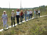 |
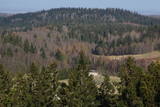
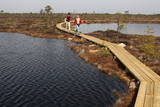
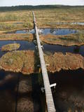
This is a highland swamp with several little lakes. At the SE of the area is a wooden trail.
|
|
 |
Национальный парк Соомаа был создан в 1993-ем году для защиты больших болот, заливных лугов и лесов. В гостевом центре парка можно познакомиться с информацией о туристских тропах Соомаа и других местных услугах, также познакомиться с постоянной экспозицией и медиа-программами. Здесь же начинается учебная тропа, которая знакомит с жизнью бобров. Соомаа известна своими наводнениями (март- апрель), это время называют пятым временем года. Во время высокой воды в Соомаа организуются путешествия по лесам, лугам и рекам на каноэ и лодках-долбленках (www.soomaa.com). Национальный парк Соомаа — единственное место в мире, где можно научиться древнему искусству создания лодки-долбленки и принять участие в практическом лагере. |
|
 |
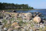
This reserve dates back to Lake Ancilus, which was one of the original elements of what is now the Baltic Sea. The lake’s ancient shores feature wetlands, forests and flora which are all protected by the reserve.
|
|
 |
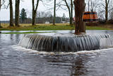
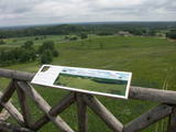
This is the first national park in Estonia and the Baltic States. Perfect for a day trip out from Tallinn for a hiking trip and nature watching. It was established in 1971 to protect the area that is along the Bay of Finland – the shoreline, forests, swamps, meadow biotopes, species, natural monuments, rocks, waterfalls, cliffs and cultural monuments such as ancient cemeteries, castle hills, baronial estates, fishing villages, etc. |
|
 |
Das größte im Baltikum. Marathonloipe von Tartu, Wand der künstlichen Felsen und Trasse der Radmarathon. Skimuseum. Auf der Tehvandi-Sprungschanze ist ein Aussischtsplatform eingerichtet. |
|
 |
This reserve was set up to protect local swamps and surrounding wetlands. Please note that before you can visit the reserve, you must register with the local administration and visitor centre in the village of Tooma.
|
|
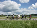 |
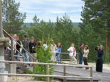
This park is found in the Otepää highlands and offers an outstanding example of how the terrain of a protected natural territory can be used for recreation, sports and active leisure. The infrastructure of the park is perfect for such activities and is of a high level of quality.
|
|
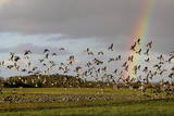 |
Национальный парк Матсалу (48 610 га) создан для охраны гнездящихся, линяющих и пролетающих птиц. В 1976-ом году Матсалу был занесен в список Рамсара. Матсалу является международно значимым местом остановки различных водоплавающих и других перелетных птиц и становится все более популярным регионом для наблюдений за птицами во всей Европе. В Матсалу имеются многочисленные природные тропы и 8 вышек для наблюдений за птицами. |
|
 |
This park is in a region of hillocks in the Karula highlands, and Lake Ähijärve is at its centre. The park offers a cultural environment of small farms, and it was set up to protect the unique cupola-shaped hillocks of the area. Main attractions: Scenic Lake Ähijärv (176ha), Rebasemõisa Tornimägi hill (137.8 m above sea level), undulating landscapes. |
|
 |
The national park was established to protect the 100 or so small islands that make up the archipelago of the local area. The largest island, the Vilsandi Island, is 6 km long and up to 2 km wide. You can rent a boat to get there, or, during appropriate conditions, you can walk across the sea and the small islands from the southern end of the Kuusnõmme peninsula.
|
