
| Нo | Название | Описание |
|---|---|---|
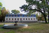 |
Жагаре с давних пор славится особым сортом вишен «Žagarvyšnė» («Жагарская вишня»). Существует несколько разновидностей этого сорта, которые различаются по времени созревания, урожайности, форме деревьев и другим признакам. Эти вишни и сейчас растут почти в каждом местном саду, став уникальным символом поселка Жагаре. |
|
 |
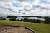
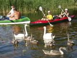
Veisieji reģionālais parks (Veisiejų regioninis parkas) veidots (1992.g.) Sudavas augstienes (Sūduvos aukštuma) ainavu, bioloģiskās daudzveidības un kultūras pieminekļu aizsardzībai. Viena no parka bagātībām ir ezeri, kuru iegarenās formas liecina par ledāja darbības rezultātu. Pēdējā apledojuma laikā šeit atradusies ledāja mala. Ezerus (kopā – 37) ieskauj lielāki meža masīvi uz kontinentālām (iekšzemes) kāpām, kas piemēroti atpūtai dabā, dabas vērošanai, ogošanai un sēņošanai. Parkā ir iekārtotas peldvietas, kur patīkami gremdēties vasaras tveicē, izveidotas dabas takas, bet mazās upītes, kas savieno ezerus, ir piemērotas braucieniem ar kanoe laivām. Veisieji reģionālā parka teritorijā ir liela augu un dzīvnieku daudzveidība. Šeit tiek aizsargātas arī tādas retas sugas kā Eiropas kokuvarde Hyla arborea (parka simbols), purva bruņurupucis Emys orbicularis, dažādas orhideju sugas u.c. |
|
 |
This park is located in the northern part of the Žemaitija Highlands, and much of it is taken up by Lake Plateliai. The park was established to protect lakes, rivers, wetlands and forest ecosystems, as well as the local cultural environment.
|
|
 |
The territory is established in order to protect the dunes and the seashore habitats. There are beautiful beaches and wooded dunes, and the paved Klaipēda–Palanga bikeway trails through the park, which is worth travelling at full length. |
|
|
|
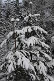
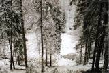
Tītuvēnu reģionālais parks (Tytuvėnų regioninis parkas) dibināts 1992. gadā. Parkam raksturīga ainavu daudzveidība – te ir sastopami lieli mežu masīvi, purvi, ezeri, upītes. Šejienes reljefa veidotājs tāpat kā citur Baltijas valstīs ir bijis ledājs, kas atnesis un atstājis aiz sevis garas laukakmeņu grēdas. Kopumā parkā ir konstatētas 603 augu un 787 dzīvnieku sugas. Parkā aug veci un dabiski boreālie (ziemeļu) meži, veci un jaukti platlapju meži ar ozoliem, liepām, kļavām, ošiem un gobām, sugām bagāti egļu meži, staignāju meži, nogāžu un gravu meži, purvaini meži un aluviālie (pārplūstošie) meži. Parkā esošās pļavas un tīrumi ir nozīmīga dzērvju atpūtas vieta migrāciju laikā, kad te pulcējās tūkstošiem putnu. Šiluvas baznīca un Tītuvēnu klosteris ir svētceļnieku galamērķis vairāk nekā 500 gadu garumā. |
|
 |
This territory is rich with forestland and lakes (some 285 in all). There are extensive opportunities for active recreation or calm leisure.
|
|
|
|
Gegründet für den Schutz der Landschaften und der Seen der Aukštaitija-Anhöhe, Arten und Biotope. |
|
 |
In the central part of the Žemaitija Highland, this park was established to protect local landscapes. Lithuania’s highest hillocks are found here – Mėdvegalis (235 m above sea level) and Šatrija (229 m). There are also other hillocks which offer a great view of the area – make up your own tour here.
|
|
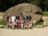 |
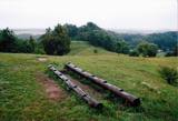
The “backbone” to this park is the valley of the Šventoji (Holy) River. One of the most impressive Devonian cliffs in Lithuania can be seen from the river – Vetygalos atodanga. On the shores of the Varius stream is a cliff made of quartz and sand – Variaus atodanga. 6 km to the S of Anykščiai is Lithuania’s second largest rock (5.7 m high, ~100 m3) – Puntukas akmuo.
|
|
 |
The terrain in this territory was created during the Ice Age. There are the ancient river valleys of the Minija, Salantas and Erla rivers, along with groups of rocks.
|
|
 |
The Nemuna River divides up into two large streams at its estuary at Kuršių Marios, and this has established the Rusnė Island. This is a unique environmental territory with wetlands, streams, ancient rivers, lagoon lakes and flood plains which are important places for birds to nest and rest during migration season. Vast tracts of this territory are flooded each spring. The park includes the territory to the N and W of Rusne (lagoons, swamps, fishing ponds, Kuršių Marios).
|
|
 |
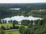
This was the first national park in Lithuania, and it is in the northern part of the Aukštaitija Higland, where hillocks interweave with lots of little lakes and ethnographic villages. Many of the lakes are connected with streams, forming long chains of lakes that are perfect for water tourists.
|
|
 |
This park covers the Nemuna River valley between the villages of Seredžius and Geldaudišķis, with lovely views of castle hills, medieval castles, aristocratic estates, etc., along the shores.
|
|
.JPG?size=160) |
This park was established mostly to protect a wide range of cultural and historical objects such as the Trakai lake castle, the ancient Trakai cloister, the Užutrakai castle, the Bražole castle hill, the heritage of ancient local tribes, etc.
|
|
 |
The park was established to protect the Venta River valley and the landscapes that are around its tributaries. On the west bank of the Venta, at Papilė, there is a cliff from the Jurassic period which is unique in the Baltic States, has been known since 1925, and has layers in which more than 300 forms of life have been identified over the course of time.
|
|
 |
This territory was established to protect the lovely central section of the Neries River, local species, and Lithuania’s largest oak forest.
|
|
 |
This is a small area with lots of different terrains – high hillocks, distinct river valleys, thermal streams, continental dunes, etc.
|
|
 |
This territory in the northern part of the Dzūkija Highlands with lots of hillocks and lakes. The most interesting tourist destination is Velnio duobė (Devil’s Flowerbed) – a funnel-shaped hole that is up to 40 m deep and 200 m wide and is thought to have originated during the Ice Age.
|
|
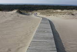 |
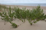
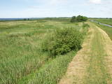
This is the only place in the Baltic States where there is such a vast territory of open-air sand dunes which still change the local terrain very actively because of the wind. The only Sea Museum and Dolphinarium in the Baltic States can be found here.
|
|
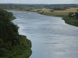 |
This lovely part of the Nemuna River between Alytus and Pakuonis meanders through cliffs that are up to 40 m high.
|
|

