
| No | Name | Description |
|---|---|---|
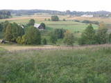 |
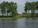
This restricted area protects the highest hillock in the Alūksne highlands – Dēliņkalns Hill – as well as the biotopes on its hillsides. The local landscape is also protected. Downhill ski trails are on the mountain, and its southern side offers lovely views.
|
|
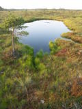 |
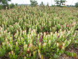
This territory was established to protect the rare tree specie in Latvia - common hornbeam, which covers approximately 4% of the territory, but the most visually interesting part of the area is the Tīrspurvs swamp, also known as the Dunika heath. This is where the visitor will find Latvia’s longest and most impressive swamp footpaths, which crosses the area from the North to the South. Visitors will be fascinated by the unique landscape of the central part of the swamp, where in some places there are not even small swamp pine trees. Various habitats will be found – small swamp lakes, mineral islands, marsh pools, etc., and that is to say nothing of all the birds in the area. |
|
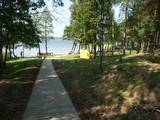 |
There is a small and relatively hard to reach area on the western shore of Lake Būšnieks which has been restricted to protect swamp habitats and several protected plants. Boat base is on the northern shore of the lake offers boat rental. From the plank-way good sites of eutrophic part of Lake Būšnieks can be seen. A well-appointed recreational facility (not included in the restricted area) is on the opposite shore of the lake. |
|
 |
This is a diverse territory in terms of biotopes and landscapes, and the restricted area was established to protect nesting and migrating birds in the area. One part of the swamp has a cranberry farm – one of the first artificially established farms of its type in Latvia.
|
|
 |
Līčiem, pussalām un salām bagāts ezers ar izrobotu krasta līniju, kas savienots ar Zvejnieku un tālāk - citiem Latgales augstienes ezeriem. Ozolu un platlapju meži, kas aug uz ezera salām un pussalās ir ne tikai aizsargājami, bet arī Latvijas mērogā nozīmīgi biotopi. Tiesa, to vērtību apzināsies tikai vides speciālisti. No Jašas ezera var uzsākt laivu braucienu pa vienu no Latgales ezeru "kēdēm". Ezera austrumu krastā atrodas Geļenovas parks.
|
|
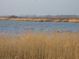 |
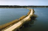
A shallow, eutrophic (more than 60% coverage), lagoon-type lake, which is a restricted area to protect the overgrowing lake and the damp meadows which surround it. There are some 60 species of nesting birds in the area. The system of dams on the southern shore of the lake can be used by visitors to look at the area.
|
|
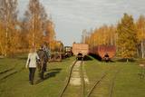 |
Sedas purva kājnieku maršruts atrodas dabas liegumā Sedas purvs, pārgājienu pa maršrutu iespējams apvienot ar Sedas pilsētas apskati, kas ir unikāls 20.gs. 50.–60. gadu pilsētbūvniecības un arhitektūras paraugs - kūdras purva strādnieku pilsēta. Maršrutam ir divi apļi - Jērcēnu aplis - 5,5 km un Sedas aplis - 4,2 km. Tajos apakatāms izstrādātais kūdras purvs, šaursliežu dzelzceļš, ritošais sastāvs, divi skatu toņi. Rudenī un pavasarī - putnu migrācijas lāikā - interesanta vieta putnu vērošanai. GPS koordinātes: Jērcēnu puses aplim: 57.7055987, 25.7001324; Sedas puses aplim: 57.6699587, 25.7514815. |
|
 |
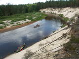
Nature restricted area is located to the South from former railroad Ventspils-Liepaja and includes approximately 6 km of Uzava River (and the old drainage system). The territory was used for agriculture during Soviet time, now it starts overgrow by scrubs. The protected nature values – rare bird species, including corncrakes, variety of grassland habitats and plant species. Territory is not useable for tourism activities. There is a possibility to get good insight into the North part of restricted area from the road Alsunga – Berzkalns where information stand is located.
|
|
 |
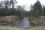
This comparatively large territory is found to the South of the Irbe River and Stende River, and it is unique with more or less virginal forests and dunes. The Irbe River has a system of ancient tributaries, and the Dižpurvs swamp is parallel to the shoreline. The Irbe has become a popular river for water tourism in recent years, but the tourist infrastructure on its banks remains insufficient. Territory has good road connections and has potential for nature education activities. |
|
 |
This territory is to the North of Skrunda, and it is an important location for water birds during their migration. Northern swans nest in the ponds, and sea eagles and other birds such as falcons and plovers use them for feeding. This is a good place for bird-watching, although it has not been particularly structured for that purpose. |
|
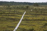 |
The tower is in the western part of the Vasenieki swamp, and an interesting nature trail with information stands and pathways was recently established there. The tower offers a look at unique swampland – visitors can survey the entire swamp. Wear proper footwear when it is damp outside!
|
|
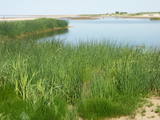 |
This area is full of coastline meadows, lagoons, muddy little lakes and sandy shallows, all full of reeds. This area of the eastern shore of the Bay of Rīga is found between Ainaži and Kuiviži. The Randa meadows are an enormously important location for water birds and rare plants – some 500 in all. A new bird-watching tower and a nature trail have been established for those who wish to study the meadows.
|
|


