
| No | Name | Description |
|---|---|---|
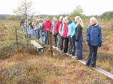 |
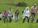
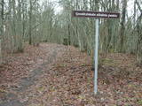
The tower is locatede in the Niedrāji-Pilka swamp. Access it via the old Ainaži-Valmiera-Smiltene narrow gauge rail line, which dates back to 1912, and then take the wooden footpaths which are approximately one kilometre long. This is a high-type swamp with small lakes at the foot of the tower. It is in the ZBR. |
|
 |
The Lake Lubāns depressions which are alongside the lake’s western and south-western parts feature little-changed forests and swamps, where many rare and protected birds nest. Many uncommon and protected habitats are in the region.
|
|
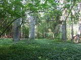 |
The Ukri forest on the border of the Dobele district is what is known as a vast forest. It has oak trees (including many huge ones), linden trees, oak trees (large stands of oak are uncommon in Latvia), and other deciduous trees. A small area of the forest can be toured in the company of a guide to look at the animals of the area and their importance in the flow of nature. The restricted area protects forest habitats, plants and animals, including many that are typical of the southern areas of Latvia. |
|
 |
Covered with rocks and with small capes and inlets, this is the eastern shore of the Bay of Rīga and the only place in Latvia where sandstone outcrops are found. These are the result of the abrasive effects of waves between Tūja and Vitrupe. Among the most distinguished of these outcrops are the Veczemi cliffs, which are less than half a kilometre long and up to four metres high. The area has been improved for tourists. It has to be said that this part of the shoreline changes very often, particularly after large storms.
|
|
 |
Relatīvi grūti pieejama un cilvēka mazskarta teritorija kūdrā izstrādātajā Cenas tīreļa ziemeļaustrumu daļā, kur saglabājušies augstā purva biotopi ar purva ezeriem, kas kopumā veido nozīmīgu vietu ligzdojošām un migrējošām zosveidīgo, tārtiņveidīgo u.c. putnu sugām. Teritorija nav piemērota (un nav vēlams) tūrisma aktivitātēm.
|
|
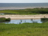 |
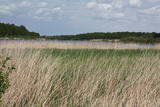
After a big storm in 2005, the nature trail of the Randu meadows was restored. It is about 4 km long, and there is a bird-watching tower which offers a fine view of unique shoreline meadows with small lagoons and areas of reeds. It is a fine place to watch migrating birds. This is part of the Northern Vidzeme Biosphere Reserve (ZBR).
|
|
 |
There is no need to enter the bog to see it, there are good views from the highway Ventspils – Riga (77 km, bus stop “Pagrieziens uz Elkskeni”). The main value of restricted area is chalky fen bog with brown bog-rush (greatest habitat finding in Latvia). Be careful when stopping on the highway – mind the traffic! A couple of kilometers towards Riga, on the right side of the highway, there is sign to Grizu Velna kresls ( Grizu Devil Chair) which is an attractive boulder (protected).
|
|
 |
Dabas liegums veidots ainaviskā Kāla ezera trīs salu (Tolkas, Lielā Vestienas un Vistu sala) un to mežu biotopu aizsardzībai. Diemžēl, salu apmeklētāji (makšķernieki?) aiz sevis ir atstājuši ne tikai nelabiekārtotas apmetņu un ugunskuru vietas, bet arī atkritumus. Tā kā salu vērtību spēs novērtēt tikai zinošs speciālists, ieteicams dabas liegumu vērot no skaistajiem un pauguriem klātajiem Kāla ezera ziemeļu un austrumu krastiem. Teritorija atrodas Vestienas aizsargājamo ainavu apvidū.
|
|
|
|
Atrodas Zebrus ezera austrumu krastā pie Latvijas Valsts mežu laivu bāzes. No torņa labi pārskatāms Zebrus ezers, ziemeļu virzienā – Ezerlūķu pilskalns. Laivu bāzē – atpūtas vietas. |
|
 |
This territory was established to protect the rare tree specie in Latvia - common hornbeam, which covers approximately 4% of the territory, but the most visually interesting part of the area is the Tīrspurvs swamp, also known as the Dunika heath. This is where the visitor will find Latvia’s longest and most impressive swamp footpaths, which crosses the area from the North to the South. Visitors will be fascinated by the unique landscape of the central part of the swamp, where in some places there are not even small swamp pine trees. Various habitats will be found – small swamp lakes, mineral islands, marsh pools, etc., and that is to say nothing of all the birds in the area. |
|
 |
This territory is on both sides of the central section of the Raķupe River. On the banks of the river, there are many different meadow habitats, as well as massive oaks growing in the places of former farmsteads which are uninhabited by now. This is an important place for rare plants and animals. There is no tourism infrastructure for visitors in the area. Visitors who are especially interested in the environmental cognition are advised to visit the territory in attendance of experienced local guide. Raķupe is not usable for water tourism because of tilts of trees and beaver dams. |
|
 |
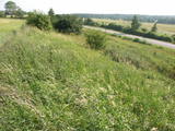
The restricted area was set up to protect Nesaule Hill, which is a forested hillock in the area and features boreal and damp forests.
|
|
 |
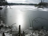
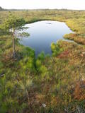
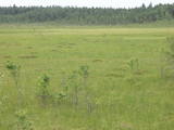
This restricted area was established to protect a high-type swamp, a swampy forest and a series of rare birds. The Niedrāji-Pilka swamp can be crossed with dry feet while enjoying almost virginal nature. This is possible on the narrow-gauge railroad embankment which runs through the swamp for three to four kilometres from the North-east to the South-west, or on the well-appointed circular wood pathway which is on the eastern size of the embankment.
|
|
 |
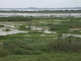
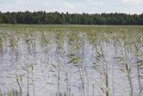
The main “treasure” in this restricted area is the shallow and eutrophic lake, which is home to many important birds. The lake and its flood-land meadows also feature many different plants. The Svētupe River flows from the northern part of the lake.
|
|
 |
Dabas liegumā "Pilskalnes Siguldiņa" ir izveidota dabas taka - kājinieku tūrisma maršruts – t.s. Augšzemes ainavu taka, kas sākas Pilskalnē un beidzas pie Driģeņu mājām. Tā izlīkumo ezeru krastus, šķērso purvu (laipas). Apmeklētājiem, t.sk. arī bērniem, izveidotas arī īsākas - lokālas takas. Pieejami dažādu taku garumi: 1,6 km, 3,8 km, 8 km. |
|
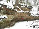 |
The Kaļķupe River valley was established as the Pilsupe River (formed by Kaļķupe River and Mazupe River) crossed the Blue hills of Šlītere to the South of Vīdale and Kaļķi. The distinct river valley has a branched network of gullies in which Devonian sandstone has been uncovered and can be seen in some locations. Puiškalns Hill (located at confluence of Kaļķupe River and Mazupe River), which was used as a castle hill and as a sacred location long in the past, is one of the most distinctive parts of the area. It is a popular tourist destination in the Talsi District. Hillside forests, various kinds of meadows and a wide range of plants are also of value in the local environment. |
|
 |
This territory protects the shore of the onetime Baltic lake of ice, which most significant part stretches for 10 kilometres on the eastern side of the Grobiņa-Ventspils highway from Kapsēde till Vērgale bus stop. From the top of this ancient shoreline there is a lovely view of the Piejūra lowlands, but no specific viewing areas or information stands have been installed. There are protected species and habitats in the territory. |
|
 |
There is picnic area and information stand at the end of the forest path leading from Muiznieki to Klanu Bog. Klanu Lake was formed in the place of Littorina marine lagoon. Nature restricted area was established to protect biotopes in the area of Klanu, Dziru and Stavu Lakes. There is wide information about the area available on the information stand.
|
|
 |
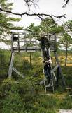
Dabas liegums veidots salīdzinoši neliela pārejas tipa purva aizsardzībai. Purvu lieliski var pārredzēt no nelielā skatu torņa.
|
|
 |
Zilais (Blue) Hill is the highest point in the Idumeja highlands – it is a very distinct hillock covered by forest, and from it there is a “narrow” landscape featuring the northern part of the highlands, as well as the Burtnieks flatlands. The restricted area is there to protect habitats such as gullies, hillsides and the boreal (northern) forest of the area. Zilais Hill is a popular tourist destination.
|
|


