
| Nr | Name | Beschreibung |
|---|---|---|
 |
Akmensrags (das Steinkap) – ist ein wichtiger Ort für Vögel während der Migration, Überwinterung und auch im Sommer während dem Federtausch. Von den geschützten Vogelarten begegnet man hier am meisten der Zwergmöwe, dem Sterntaucher und dem Prachttaucher. Das Territorium befindet sich gegenüber der Region Pāvilosta und die Fläche beträgt 25 878 ha.
|
|
 |
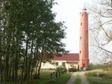
Einer der ausgeprägten Kaps der lettischen Küste mit Niederungsauen und einem in 1875 gebauten Leuchtturm. |
|
 |
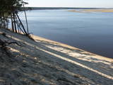
Die Küstenbildungen des alten Ostseestadiums – Littorina-Meer treten in Natur als eine nicht große und flache Steilküste auf, die sich etwa vor 4500 – 5000 Jahren bildete. Ein Material der Küstenablagerungen – Geröll und Kies beinhalten ein für das Littorina-Meer kennzeichnendes reichstes Komplex der Faunareste. Am Besten ist der alte Meeres-Steilhang bei dem Hof “Dobeļi” in Kaltene zu beobachten. Der Steilhang der alten Küste in Kaltene ist einer der wenigen Abschnitte an der Küste der Rigaer Bucht, wo während des Littorina-Meeres eine Abrasionsküste war. In den flachen Meeresbuchten nähren sich und erholen sich die Zugvögel. (Die Quelle: Roja TIZ) |
|
|
|
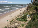
Pie Melekiem sākas dabas lieguma teritorija. Meleku
krastmala būtiski mainījās 2005. g. orkāna laikā.
|
|
 |
Das ist ein langgestrecktes Gebiet zwischen der Ostsee und der Straße Kolka – Ventpils. Es beginnt an der Mündung des Flusses Irbe und endet in Ovīšrags. Das Territorium wurde vor allem eingerichtet, um den trockenen Koniferenwald, die Graudünen, Feuchtbegiete zwischen den Dünen, andere Landschaftserscheinungen, Pflanzen und Tiere in dem Gebiet zu schützen. Touristen lieben die sandigen und ruhigen Strände in dieser Gegend, die Leuchttürme von Miķeļbāka und Ovīši und die lutherische Kirche in Miķeļbāka. Hier gibt es auch noch einige Hinterlassenschaften des sowjetischen Militärsystems, die nicht touristisch genutzt werden.
|
|
|
|
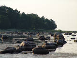
Izteiksmīgs zemesrags, kas klāts ar
dažāda lieluma laukakmeņiem.
|
|
 |
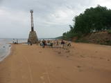
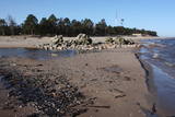
In Roja kann man sowohl einen Sandstrand mit eingerichteter Infrastruktur als auch die Steinküste finden. An der Steinküste befindet sich ein Seegeröll von Roja – etwa 2m hoch und 12,5 m im Umfang. Für die Meeresküste ist der Zauber der Landschaft mit zerstreuten Steinen und der gemächliche Lauf der Zeit bezeichnend. Bei der Mündung des Flusses Silupīte ins Meer kann man noch heute Holzfragmente einer alten Barke und Reste der Eisennagel jener Zeit sehen. Seit dem Jahr 1939 war Roja der “Anfangspunkt” der sogenannten “abgesperrten Zone”, in der sich bis zum Jahr 1993 eine Dislokationszone der sowjetischen Armee und Flotte befand. In den Dünen bei der Krasta Straße ist es noch möglich das militärische Erbe der Sowjetzeit zu sehen. Hier befindet sich einen großen Betonaufwurf, von dem die Grenzwächter seinerzeit das Meer überwachten und die Grenzverletzer fingen.Hinter den Dünen befand sich einen Gefechtsübungsplatz der Grenzwächter mit allem Nötigen. In Roja befand sich sowohl eine Grenzwacht als auch einen Flugabwehrradar. (Die Quelle: Roja TIZ) |
|
 |
Kap Ragaciems – der Vorsprung an der
westlichen Küste der Rigaer Bucht, der mit
einer seichten und steinigen Sandbank
mehrere Hundert Meter weit ins Meer
hineingeht. An der Spitze vom Kap befindet
sich der Leuchtturm von Ragaciems.
|
|
 |
Бернати - самая западная точка суши Латвии. Рядом с автостоянкой установлен каменный знак скульптора Вилниса Титанса «Зеленый луч» (1998 г.). Бернатский мыс подвержен воздействию ветра и волн, поэтому здесь наблюдается вымывание морского берега. У дороги, которая из центра поселка Бернати ведет к морю, в конце дюн (имеется указатель), установлен памятный камень со словами первого Президента Латвии Яниса Чаксте, сказанными в 1924 году: «Здесь должен быть курорт». |
|
 |
Ķurmrags is one of the most distinct capes along the Vidzeme shore of the
|
|
 |
"Valgums" is a word referring to the sandy coastline zone between dunes and water, and once there were boats and nets that were being dried at this location. Each village had several areas of this type, and in the 1920s and 1930s, these were of great importance in the preservation of the Liv language. |
|
 |
Ein wichtiger Komplex an Küstenlinie und Sanddünen entlang der Mündungen der drei Flüsse – Lielupe, Daugava und Gauja. Diese Gegend hat sehr alte Traditionen für Erholung und Kurbetrieb. Das Gebiet hat eine wunderschöne Küstenlandschaft und weist eine der wenigen Küstenwiesen von Lettland auf. Der Park umfaßt auch einige geschützte Areale – die Wiesen der Lielupe – Mündung, Vakarbuļļi, Daugavgrīva, Vecdaugava und Ummis (siehe Abteilung “Geschützte Naturareale”). Interessante Naturelemente in dieser Gegend sind das Amphitheater der Garciems – Dünen, zusammen mit einzelnen Dünen wie der Legzdiņi – Düne und der sogenannten Skiberg – Düne. Besucher werden durch verschiedene Kulturdenkmäler angezogen - den Befestigungsanlagen auf der Mangali – Insel, Militärbauten aus der russischen Zarenzeit bis zum Ende der sowjetischen Okkupation, der Festung von Daugavgrīvak, dem Vecāķi Kurbad mit seinen alten Küstenbauten und den Stränden von Daugavgrīva und Vecāķi. Die Nähe zur Stadt Riga und die verschiedenen wichtigen Erholungseinrichtungen sind der Grund für die vielen Erholungssuchenden in diesem Gebiet. Der Naturpark ist für aktiven Tourismus geeignet (wandern, Rad und Boot fahren, Autosport), Langlaufski, Natur- und Vogelbeobachtung, Kulturtourismus, passiver Freizeit- und Bildungstourismus. Es gibt Naturpfade in den Daugavgrīva- und den Rožu-Dünen zusammen mit anderen Einrichtungen der Infrastruktur.
|
|
 |
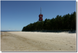
Das Kap Kolka – ist das ausgeprägteste Kap an der lettischen Meeresküste, wo man den Zusammenstoß
der Wellen von zwei „Meeren“ – der Ostsee (das große Meer) und der Bucht von Riga (das
kleine Meer) beobachten kann. Das Kap geht noch fünf Kilometer als Sandbank weiter ins Meer bis
zum Leuchtturm von Kolka. Am Kap Kolka geht die Sonne im Meer auf und runter, deshalb kann man
hier phänomenale Sonnenaufgänge und Untergänge beobachten. Das Kap Kolka ist aber auch ein
gefährlicher Platz für Schwimmer wegen der unbeständigen Strömungen und Treibsand. In den
Dünen beim Kap Kolka ist ein von Bildhauer G. Burvis gefertigtes Denkmal für „Die vom Meer Genommenen“
aufgestellt. Es ist eine symbolische Pforte, durch die man den Leuchtturm von Kolka sehen
kann. Noch gibt es ein altes Schiffswrack, den Stein – das Zentrum Europas und K. Valdemars
gewidmete Informationsstände zu besichtigen. Von außen kann man auch eine alte sowjetische
Militärbasis besichtigen, die heutzutage vom lettischen Grenzschutz genutzt wird. Während der
Frühlingsmigration
der Vögel ist das Kap ein bedeutender Platz für Wandervögel, die hier Rast machen
und sich erholen. Dieses Naturschauspiel lockt viele Vogelbeobachter an. Für die Bequemlichkeit der
Besucher gibt es einen Parkplatz, Bänke mit Tischen und ein Besucherzentrum. In der Sommerzeit gibt
es auch ein kleines Café – eine großartige Möglichkeit sich zu kräftigen!
|
|
 |
Dieses Territorium umfasst den Küstenabschnitt zwischen der Straße Ventspils-Liepāja und der Ostsee auf beiden Seiten des Flusses Užava. Das Gebiet wurde eingerichtet, um sowohl die Küstenbiotope wie die Graudünen und als auch eine Reihe von gefährdeten Pflanzen zu schützen. Südlich der Mündung der Užava steht oben auf einer steilen Düne einer der romantischsten Leuchttürme von Lettland – der Užava – Leuchtturm.
|
|
 |
Bedeckt mit Findlingen und mit kleinen Landspitzen und Buchten – dies ist die Ostküste der Bucht von Riga und das einzige Gebiet in Lettland, wo Sansteinaufschlüsse zu finden sind. Diese sind das Resultat der abschleifenden Wirkung der Wellen zwischen Tūja und Vitrupe. Die eindrucksvollsten Aufschlüsse haben die Veczemi – Felsen, die etwas weniger als einen halben Kilometer lang und bis zu 4 m hoch sind. Dieses Gebiet wurde touristisch verbessert. Man muss sagen, dass sich dieser Teil der Küste sehr oft ändert, besonders nach großen Stürmen.
|
|
 |
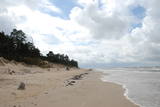
Die Steilküste beginnt ein Paar Kilometer weiter im Norden von Pāvilosta und endet kurz vor Ošvalki. Die eindrucksvollsten und interessantesten Formen sind auf der Strecke Strante – Ulmale und in der Umgebung von Jurkalne zu sehen. |
|
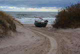 |
Ceļa, kas ved uz jūru – galā, redzami Latvijas piekrastei samērā reti skati. Ja palaimējas, šeit var novērot vietējos zvejniekus darbībā, kas joprojām iet zvejā. Krasta kāpās aplūkojamas vecas, pamestas un arī sagrieztas zvejas liellaivas un dažādi mūsdienu zvejniecībā izmantojami „darba rīki”. |
|
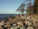 |
Neliels, bet ļoti ainavisks un ar lieliem laukakmeņiem klāts
zemesrags. No raga iztālēm redzamas Veczemju
klintis.
|
