
| No | Name | Description |
|---|---|---|
 |
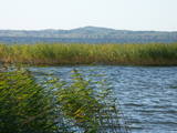
Elka Hill is one of the highest surfaces in the western part of the Vidzeme highlands, and it offers a lovely and broad view to the North. There is a small parking lot, a TV and radio tower, and the place where the Gauja River is thought to originate.
|
|
 |
This is an area that is full of legend and tale. There is a stiff hillock, which stands about 66 metres above the surrounding land. From its southern side, you can see the Burtnieki lowlands. The tower, however, is not open to the public.
|
|
 |
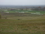
A beautiful part of the Rēzekne-Dagda-Krāslava road – along two km or so, you can see Lake Rāzna and Mākoņkalns hill, which is 10 km away on the other shore of the lake. |
|
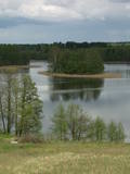 |
In Vecslabada, there is a peninsula among Lake Dziļezers, Lake Audzeļi, and Lake Istra. From the highest point on the peninsula, you will see a truly unusual view of the land of the blue lakes – lake islands, as well as the village of Vecslabada with its church towers. The Lake Istra nature reserve is nearby.
|
|
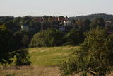 |
The hill is the highest point on the shores of the little Slocene River valley, and it is located in Tukums, at the side of Jelgavas Street. It opens up a broad view of the Slocene River valley and the town of Tukums with its historical centre on the opposite side of the valley. The view is particularly interesting in the evening, when the town is lit up. There is a monument to the liberators of Tukums.
|
|
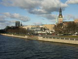 |
The classical skyline of Old Rīga can be enjoyed from several locations – Mūkusalas Street, between the railroad bridge and the stone bridge, from the stone bridge, from the A-B dam, from the grounds of the central office of the Swedbank bank, from the Vanšu bridge, and from the Ballast Dam at Ķīpsala. You can hike or bike from location to location. During the summer, little ships cruise up and down the Daugava to offer different views.
|
|
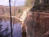 |
The viewing area on the Ērgļi (Ērģeles) cliffs offers an impressive view of Latvia’s most monolith sandstone cliffs (up to 22 metres high) – this is the highest location in the Gauja River valley. Please be very careful and don’t go anywhere near the edge of the cliff!
|
|
 |
The town of Talsi is known as the “town of the nine hillocks,” and it is worth touring the location on foot. You’ll find the best views from the Talsi castle hill (views of Lake Talsi and Ķēniņkalns Hill), Sauleskalns (Lake Talsi, the castle hill, Ķēniņkalns Hill), and the hiking trails of Ķēniņkalns (Lake Talsi, the castle hill, the historical town centre).
|
|
 |
The viewing area is near the top of the Vilce castle hill, with a view of the Rukūze River valley, Zaķi meadow, and surrounding forests. This is an unusual landscape for the region of Zemgale. The Vilce baronial estate is nearby.
|
|
 |
The eastern, southern and western shores of Lake Rāzna have roads which offer many lovely and unusual views of Latvia’s second largest lake and its surrounding landscape. Particularly lovely is the road between Foļvarkova and Vilkakrogs, which is part of the Rēzekne-Ezernieki road.
|
|
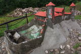 |
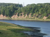
The Naujene castle hill is on the steep bank of the Daugava River, is up to 25 metres high and has two valleys on its sides. Between 1275 and 1277, the master of the Livonian Order, Ernst von Ratzenburg, organised the construction of a brick castle to replace a Lettigalian wooden castle that had stood there before. The castle had a drawbridge and an external and internal forecastle. Until the middle part of the 16th century, the castle was the residence of one of the top officials in Dünaburg. The forces of Ivan the Terrible sacked the castle in 1577, after which the location lost its strategic importance. New fortifications were built in the location that is now the city of Daugavpils. Alongside the ruins of the castle is a miniature model that helps to imagine the appearance of the location many centuries ago. A well-appointed pathway leads from the car park to the castle hill. The hill offers one of the loveliest views of the curvy Daugava River and its surrounding nature park. |
|
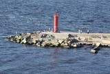 |
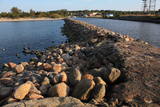
The Eastern breakwater was installed in the mid-19th century to reduce silt in the river valley and to regulate the flow of water. It is made of wooden pilings that are covered with rocks. The breakwater is 2.2 km long and has been rejuvenated as a popular place for hiking, leisure and fishing throughout the year. Birds can be watched from the breakwater, and sometimes people are lucky enough to spot a seal. At the start of the breakwater are two rocks with engraved text to say that the site was visited by Russian Tsar Alexander II in 1856 and by his heir, Nikolai Alexandrovich, in 1860. This points to the importance of the Rīga port in terms of Baltic Sea trade routes at that time. |
|
 |
Latvia’s highest hill is the second highest in the Baltic States, but alas, it has only a wrecked viewing tower, so you’ll have to look for the best views on your own. You’ll find some around the tower and the ski trails, particularly Large and Small Golgotha. It is worth hiking the Gaiziņkalns nature trail.
|
|
 |
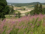
In Aizkraukle, drive down Enerģētiķu Street to the Selonian side (there will be small “pockets” at the side of the road) to see one of the best views of the Daugava River valley, reminding us of what this fateful river was like before the power plant was built. You will see that the river has eroded the steep cliffs on the right bank. The further part of the valley is part of the Daugava Nature Park.
|
|
 |
Molu (sākotnēji – pāļu rindas ar akmeņu krāvumiem) izbūve pie Sakas ietekas jūrā tika uzsākta 1878. gadā, lai nodrošinātu ostas darbību. 1929. gadā notiek molu pārbūve, pagarinot tos ar masīviem betona blokiem. Pēdējā rekonstrukcija notika 2010. gadā, pārveidojot molus par ērtu pastaigu un makšķerēšanas vietu, no kuras var vērot arī saulrietu. |
|
 |
An all-encompassing view of the urban environment next to the Daugava River valley is offered at the car park which is at the start of Augusta Street on the boundary of Krāslava. The unique wooden buildings of the area (the Kaplava Street region) can also be seen on the bridge which crosses the Daugava. Climb Karņickis Hill and hike through the park of the Plāters family of nobles. From there, you will see more local scenes.
|
|
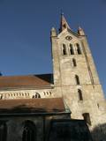 |
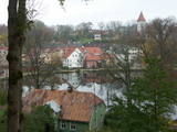
The tower of St John’s Lutheran Church in Cēsis, which is one of the oldest stone buildings in Vidzeme, offers a view of the historical centre of Cēsis, and a wide area all the way to Zilaiskalns Hill. There is also the western tower of the ruins of the Cēsis castle, one of the strongest fortresses of the Livonian Order in the Baltic region, and it offers a grand view of the castle’s park.
|
|
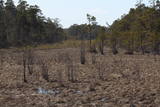 |
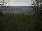
The Kurzeme Peninsula has the largest landscape of hillocks and valleys in Europe in the shoreline segment from Melnsils and Kolka to Oviši and Liepene. It is a unique landscape in Latvia, and part of it is in the Slītere National Park. The Pēterezers Nature Trail offers the best chance to look at the landscape. There are hillocks and valleys elsewhere, too – near shoreline villages where the Kukšupe valley (one of the longest ones – 8 km in all) is crossed by the Ventspils-Kolka highway, as well as near Apakšceļš. The only thing is that you need to learn how to spot the areas out in nature. |
|
 |
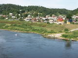
From the Markova castle hill, which you will access from the local information trial, you will see a view of the Daugavsargi curve of the Daugava. Further along, you will reach the open shore of the Daugava to see one of the most unique landscapes of Latvia’s river valleys. The Slutišķi village of Old Believers and the mighty Slutišķi cliff will be in the background.
|
|
 |
From the highest point in the Alūksne highlands, you will see an unusually beautiful view of the surrounding forested hillocks and the small areas of meadows and farmland. Sadly, there are no improvements to the location, which can be difficult to access. It is on private property.
|
|
