
| No | Name | Description |
|---|---|---|
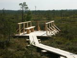 |
At the end of a wooden footpath in the Planči swamp is a viewing area and place for leisure. This is the place where you can enjoy landscapes of the high-type swamp and breathe the unusual air of the swamp. This is the only outdoor infrastructure object in Latvia with information posted in Braille. It is in the ZBR.
|
|
 |
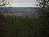
This is the highest point in the Latgale highlands (289 metres above sea level), opening up a narrow but lovely view of Lake Rāzna and the massive forests of the highlands. You really should visit this hill when the sun is setting beautifully!
|
|
 |
At the highest point of Krievkalni (149 metres above sea level), there is a good location for relaxation which offers an impressive view toward the East.
|
|
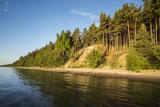 |
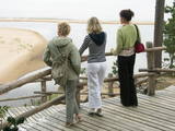
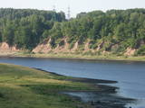
Viewing area is at the end of the Ēvaži shore trail (300 metres). The shore here has been washed by the waves and is up to 15 metres high. This is the only place along the Kurzeme shore of the Bay of Rīga where a high dune opens up such a lovely view of the bay water.
|
|
 |
The Mežotne castle hill is on the left bank of the Lielupe River and opposite the Mežotne Castle. This was one of the largest Semigalian fortified castle hills during the 9th to the 13th century, and an ancient town alongside the hill covered 13 ha of land. The castle hill has been improved. A pontoon bridge across the Lielupe allows hikers and bikers to reach the castle (between May and October). Vīna Hill is approximately 500 m to the South of the castle hill, and a wooden pathway leads to it. |
|
 |
At the estuary of the Inčupe River, there is the White Dune, which is around 18 metres high and is the most lovely element of the Vidzeme shoreline among those that have been created by the wind, sand and sea. There is a wooden footpath (the Saulriets trail) which is meant to view, but also protect the dune. It has a viewing area, too. The territory to the south of the river is in the Piejūra Nature Park.
|
|
 |
An all-encompassing view of the urban environment next to the Daugava River valley is offered at the car park which is at the start of Augusta Street on the boundary of Krāslava. The unique wooden buildings of the area (the Kaplava Street region) can also be seen on the bridge which crosses the Daugava. Climb Karņickis Hill and hike through the park of the Plāters family of nobles. From there, you will see more local scenes.
|
|
 |
The viewing area is near the top of the Vilce castle hill, with a view of the Rukūze River valley, Zaķi meadow, and surrounding forests. This is an unusual landscape for the region of Zemgale. The Vilce baronial estate is nearby.
|
|
 |
Elka Hill is one of the highest surfaces in the western part of the Vidzeme highlands, and it offers a lovely and broad view to the North. There is a small parking lot, a TV and radio tower, and the place where the Gauja River is thought to originate.
|
|
 |
This is an area that is full of legend and tale. There is a stiff hillock, which stands about 66 metres above the surrounding land. From its southern side, you can see the Burtnieki lowlands. The tower, however, is not open to the public.
|
|
 |
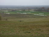
In Aizkraukle, drive down Enerģētiķu Street to the Selonian side (there will be small “pockets” at the side of the road) to see one of the best views of the Daugava River valley, reminding us of what this fateful river was like before the power plant was built. You will see that the river has eroded the steep cliffs on the right bank. The further part of the valley is part of the Daugava Nature Park.
|
|
 |
Beautiful views are accessible from the Sabile castle hill (steps, a location for relaxation), Upurkalns Hill (no improvements) and Briņķpedvāle, which part of the Pedvāle Open-Air Art Museum. There are also the Drubaži nature trails. The road between Kandava and Sabile which runs along the right bank of the Abava and the Aizdzire-Kalnmuiža road which runs on the left bank of the Abava also offer beautiful landscapes.
|
|
 |
Latvia’s highest hill is the second highest in the Baltic States, but alas, it has only a wrecked viewing tower, so you’ll have to look for the best views on your own. You’ll find some around the tower and the ski trails, particularly Large and Small Golgotha. It is worth hiking the Gaiziņkalns nature trail.
|
|
 |
The area known as the territory of high hillocks has several heights – Lakta Hill (250 metres above sea level), Egļu Hill (268 metres above sea level), and Bākūži Hill (272 metres above sea level). They are connected by an earthen road – it’s worth hiking the trail to find the best viewing areas. A very fine view of the backs of hillocks in the Vidzeme highlands can be seen from the northern side of Lakta Hill.
|
|
 |
One of the highest dunes in Latvia, located between Bernāti and Jūrmalciems villages. It is 37m high and offers a magnificent view of the sea and natural pine forests. The highest dunes in Latvia stand to the South of Jūrmalciems village: the Pūsēnu hill, the Ķupu hill, the Mietragkalns or Tiesas hill, the Pāļu hill, the Garais hill, the Ātrais hill, the Lāvas hill. The Pūsēnu dune is the highest of these dunes which are all called hills by the local people. The Pūsēnu hill developed between 1785 to 1835 when shifting sand became extremely dangerous. Several homesteads were buried in sand, among them „Pūsēni”, where a forester’s family lived. The family is said to have moved to Bārta. The dune was named after the buried homestead. Jēkabs Janševskis, a Latvian writer, wrote in his book „Nīca”: “In olden times, large pine trees were growing in the dunes on the coast of Nīca and they stood steady and firm. But i Swedish times (around 1650), the Swedes built a large kiln for charcoal and tar. Pine wood and stumps provided an excellent material for this. Once a big fire rose, and the charcoal kiln burned down as well as the whole pine forest. The remaining stumps and bare trunks in the vast burnout could not hold the storm-driven sand; it flew further and further burying not only the burned-out forest, but also the nearest fields. In wintertime, when the vast, low marshy grasslands were covered with ice, jets of sand drifted further over its surface, and soon most of the grasslands and large meadows turned into sandy heath-land and dunes.” To reconstruct Liepāja, severely damaged during WWII, a silicate brick factory was built in the town. The main raw material was white sand and it was taken from the Bernātu forest. In the 1960-ies they started to dig off the Green Dune and the White Dune, later also the Pūsēnu hill. The excavators used to work day and night, in three shifts. The work stopped at around 1980, as there was no more sand suitable for production of brick. A trail is set up to facilitate walking in the Pūsēnu Dune in the Bernātu Nature Park. |
|
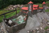 |
The Naujene castle hill is on the steep bank of the Daugava River, is up to 25 metres high and has two valleys on its sides. Between 1275 and 1277, the master of the Livonian Order, Ernst von Ratzenburg, organised the construction of a brick castle to replace a Lettigalian wooden castle that had stood there before. The castle had a drawbridge and an external and internal forecastle. Until the middle part of the 16th century, the castle was the residence of one of the top officials in Dünaburg. The forces of Ivan the Terrible sacked the castle in 1577, after which the location lost its strategic importance. New fortifications were built in the location that is now the city of Daugavpils. Alongside the ruins of the castle is a miniature model that helps to imagine the appearance of the location many centuries ago. A well-appointed pathway leads from the car park to the castle hill. The hill offers one of the loveliest views of the curvy Daugava River and its surrounding nature park. |
|
 |
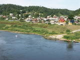
The hill is the highest point on the shores of the little Slocene River valley, and it is located in Tukums, at the side of Jelgavas Street. It opens up a broad view of the Slocene River valley and the town of Tukums with its historical centre on the opposite side of the valley. The view is particularly interesting in the evening, when the town is lit up. There is a monument to the liberators of Tukums.
|
|
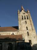 |
The tower of St John’s Lutheran Church in Cēsis, which is one of the oldest stone buildings in Vidzeme, offers a view of the historical centre of Cēsis, and a wide area all the way to Zilaiskalns Hill. There is also the western tower of the ruins of the Cēsis castle, one of the strongest fortresses of the Livonian Order in the Baltic region, and it offers a grand view of the castle’s park.
|
|
