
| No | Name | Description |
|---|---|---|
 |
This is a tour that will take you trough time and space, because it clearly reveals the history of the location since the end of the Ice Age, which created the impressive ancient Gauja river valley. Uncovered sandstone leads one back to the Devonian period, known as the “fish age” – here we’re talking about history that dates back hundreds of millions of years. Human beings arrived in the region quite recently, but they’ve also left lots of evidence behind.
|
|
 |
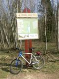
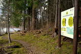
Maršruts "Murjāņi - Līgatne" ved caur Gaujas senieleju ar devona smilšakmens atsegumiem, raksturīgo augu valsti un dzīvniekiem. Krastos sastopami Latvijā lielākie nogāžu un gravu meži ar liepām, ozoliem, gobām un ošiem. Upes līkumos palienē aug baltalkšņu un vīksnu audzes. Uz koku stumbriem atrodams plaušķērpis. Senieleja bagāta ar sausokņiem un kritalām, tāpēc Gaujas krastu mežos dzīvo visu Latvijā sastopamo dzeņu dzimtas sugu putni. Smilšainajās Gaujmalas pļavās un Gaujas vecupēs ir bagātīga bezmugurkaulnieku fauna. Upes krastos ir smilšakmens klintis ar čurkstu alām un zivju dzenīša ligzdām. Klinšu pakājē iztek avoti, kas uztur mikroklimatu ielejā. Gauja ir nozīmīga arī kā Latvijas lielākā lašupe. Maršruts ir daļēji marķēts un papildināts ar norādēm un informācijas stendiem. |
|
 |
Atrodas mežā, netālu no Kaltenes. Labiekārtota (laipas, kāpnes, informācijas stendi) taka, kas iepazīstina ar Latvijai samērā neparastu dabas pieminekli (aizsargājams) – Kaltenes kalvām, kas ir lieli, līdztekus Rīgas jūras līča krasta līnijai orientēti laukakmeņu krāvumi. Uzskata, ka tos veidojuši Baltijas ledus ezera ūdeņi un ledi. Garums – ap 1,5 km. |
|
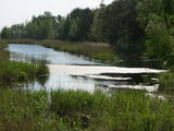 |
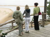
Taka izveidota 2005. gadā. Tā atrodas uz Lapmežciema un Bigauņciema robežas un izskatās kā koka dēlīšu laipa gar Siliņupi. Taka aizved līdz jūrai, kur apskatāms vecais Lapmežciema mols. Siliņupē novērojami ūdensputni. |
|
|
|
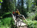
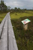
In 2006, a wooden pathway was installed across the Planči swamp – 500m long, which means that the visitor will spend around 20 minutes there. This is probably the only nature trail in Latvia for which there are plans to post information in Braille for people with impaired vision.
|
|
|
|
10 km garais pārgājienu maršruts iepazīstina ar vienu no vēl retajiem, cilvēka mazāk ietekmētajiem Daugavas senlejas posmiem. Tā sākums – Aizkraukle, finišs – Skrīveri. Gar upes krastu izvietotas atpūtas vietas. Maršrutu var braukt arī ar velosipēdu. |
|
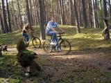 |
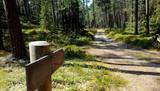
Brīvdienu mājas "Korķi” apkārtnes priežu mežā ir izveidota Jāņtarpiņu taka. Ideāla vieta aktīviem sēnotājiem un ogotājiem. Savukārt saules un jūras cienītāji pa šo taku 5-10 minūšu gājienā nonāks Vitrupes pludmalē, kur varēs baudīt sauļošanās un peldēšanās priekus.
|
|
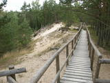 |
The trail climbs up and down along the bluffs of lower River Pilsupe and reveals a fascinating sight of three white dune exposures (the largest is called the White Dune). The trail is 900m long, and the White Dune is ca 20m high. It has formed ca 6000 years ago, in the period of the Littorina Sea which is a foregoer of the Baltic Sea. Here the first Stone Age settlement on the North Western coast of Latvia has been found in 1934 by geologist S. Burhards. In the sand, some 500m from the sea, he found some pottery fragments, a sandstone hone, a piece of flint, parts of bones and an amber bead. He handed the findings over to the National Museum of History. In October 1934, the site was checked by archaeologist E. Šturms, who found the archaeological layer, typical for such settlements, in the landslides of the Pilsupe riverbanks. In 1936 he started larger excavations to continue by 1938. Totally seven, chronologically different settlements were detected and many artefacts found, including fragments of the so called Sārnate and pit-comb pottery, as well as some pieces of corded pottery. Based on these findings, the settlement is dated back to the beginning or middle of the 3rd millenary B.C., and it has been inhabited till the beginning of the 2nd millenary B.C. Especially remarkable are three clay figures in human shape which have probably been used for some religious cult purposes. Since 1993, archaeologist Ilzes Loze has discovered several pit-comb ware culture settlements in large area around Pūrciems village. They are known in research literature as „the Ģipka settlements”. |
|
 |
Dabas takā gar Rojas upi iespējamas 3 dažāda garuma distances, kas lokveidā ved gar upi un tai pieguļošajiem mežiem – 2 km, 7 km un 15 km, kas katra atzīmēta ar savas krāsas norādēm. Dzeltenais aplis 2 km, zilais aplis – 7 km, sarkanais aplis – 15 km. Maršrutus var veikt arī ar velosipēdu, taču braucot ar velo, atsevišķi posmi var būt grūti izbraucami smilšu dēļ. Pie upes ierīkotas vairākas atpūtas vietas ar soliem, galdiem, labierīcībām, šūpolēm, vingrošanas konstrukcijām, atkritumu urnām, kā arī ugunskura un telšu vietām. Pie atpūtas vietām Žocenē un Rojā ir izveidotas arī laivu piestātnes. Takas sākumā upes krastā labiekārtota vieta, kur upē ietek Rojas avots, ko kā ūdensņemšanas vietu iecienījuši vietējie iedzīvotāji. |
|
 |
The Sunset trail starts in the centre of Saulkrasti town and takes you to the White Dune. Saulkrasti town with its municipal rural territory, occupies a 17km long stretch of coastal land to the North from the river Lilaste and the lake Lilaste. The White Dune stands on the right side of river Inčupe mouth. It is covered by old pine forest. The white, 18m high sand outcrop in olden times served as a landmark for fishermen. The White Dune formed as winds carried the sand from the beach over clay sediments of the Baltic Ice Lake. Some 150-200 years ago, the dune had been drifting as witnessed by several layers of soil buried within it. Local fishermen and farmers at Bātciems initiated afforestation of the drifting dunes. At that time, the 30m high dunes which are now covered with forest, were bare, shifting and even buried a farmstead. To speed up afforestation, mountain pines were planted. The White Dune was partly washed away in heavy storm in 1969, and 4-6m high precipice formed. Now the wind and sand have levelled out the dune surface, it has been fixed with willow-twigs or grown with forest where the largest pines are more than 170-190 years old. The pines are notable with their large trunks and branches, the scars obtained during their lifetime and the typical “crocodile skin” – the bark forms rhombuses resembling those of the reptile’s scales. Scots Pine (Pinus Silvestris) is one of the most common tree species in Latvia. It grows in dry, meagre sandy soil in dunes as well as in marsh. However, it does not stand overshadowing. Forest fires help pines to get rid of competitors as pine endures fire better than other trees because of its thick bark and high crown. The wood exudes resin and burned wounds close soon. Fire cleans space for seedlings of young pines. Pines can live 300-350 years. Ground cover in dune forests is very sensitive. If the sparse vegetation is destroyed, not only the natural biodiversity and landscape is damaged, but also the dangerous shifting dunes can possibly “wake up”. Embryonic dunes, White (yellow) dunes, Grey dunes and Wooded dunes are EU protected biotopes. Grey Dunes are protected by Latvian law as well. |
|
 |
The trail informs visitors about one of the loveliest natural habitats in
|
|
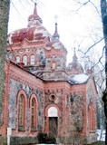 |
Nītaures vēstures takā var apskatīt un iepazīt dažādus vēsturiskus objektus no 13.gadsimta līdz mūsdienām - seno pilskalnu, vācu ordeņa pilsdrupas, luterāņu un pareizticīgo baznīcas, soda vietu un muižas seno apbūvi. |
|
 |
Takas sākums atrodas pie Veclaicenes pagasta pārvaldes (autosvālaukums). Tā izlokas gar Ievas, Trumulīša un Raipala ezeru dienvidu krastiem un pa ziemeļu krastu nogāzēm atgriežas atpakaļ sākumpunktā. Apļveida takas garums – ap 8 km. Atrodas Augšzemes aizsargājamo ainavu apvidū, Kornetu – Peļļu subglaciālajā vagā. |
|
