
| No | Name | Description |
|---|---|---|
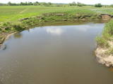 |
The Dviete Wetlands Nature Park contains a unique natural territory – the ancient Dviete River valley with the Lake Skuķi and the Lake Dviete and the surrounding wetland meadows. During flooding season, these wetlands store up waters from the Daugava River. They absorb a lot of floodwater at first and then slowly return it, thus reducing the level of floods in the Daugava River valley. This process is the reason for the unique ecosystem which exists in this area. It is an important location for plants and birds both during migration and nesting season. The river valley is important for birds during migration and nesting. In 2006, wild cows were released into the meadows. There is also work to improve the tourist infrastructure in the area. |
|
 |
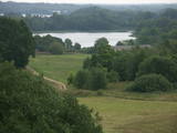
The main goal of the Vestiena protected landscape area is to protect the landscape values in the Vidzeme highlands. The protected area is in the middle of the Vidzeme highlands with the highest and most prominent relief, including Gaiziņkalns, the highest spot in the country. The many lakes found in the area - Viešūrs, Talejas, Kāls, Pulgosnis and others – not only add to the variety of the landscape, but also offer tourism and recreation options. The Vestiena protected landscape area encloses several other especially protected/Natura2000 sites – the Gaiziņkalna nature park, the island of the lake Kāla, the lake Ilziņa restricted natural area. Among the most interesting tourist attractions are the Vestiena estate, the Piekūnu wandering trails, the Gaiziņkalna nature trail. The area is rich in landscapes, however, there are no viewing spots or towers installed to observe the landscape. On the top of the Gaiziņkalns, the Latvia’s highest spot, there still stands the wreck of the former viewing tower.
|
|
 |
This lovely territory includes the hillocks of Embūte, which are in the ancient Embūte valley. The aim of establishing the park was to protect the landscape, biotopes and species of the region. An ecological tourism trail has been established in the valley, as has a forest trail through the nature park (accessibly only in the company of a guide). Visitors will learn about the hillocks and ravines left behind by the Ice Age. The ravines and the forests along their sides are protected biotopes. There are also important natural and cultural monuments, including the Embūte castle hill and the ruins of a baronial estate, castle and church. Other points of interest include the death place of the Courlandian warrior Indulis, the Joda dam, meadows, a viewing tower, etc. Three unmarked bicycle trails are in the area. |
|
 |
These are hillocks at the northern end of the Vidzeme highlands, and this is an important location for boreal (Northern) forests and swamps. Various kinds of swamps are found here, and the area is home to a variety of protected invertebrates.
|
|
 |
Latvia’s newest national park (2007) is in the “land of the blue lakes” – the region of Latgale. One of the goals of establishing a national park was to preserve the natural treasures of the region. Lake Rāzna, which is the second largest in Latvia, is there, as is Lake Ežezers, which has more island than any other lake in Latvia. There are other bodies of water, as well as typical landscapes of hillocks and a unique cultural environment. One of the most popular destinations in the park is Mākoņkalns Hill, which offers a lovely view of Lake Rāzna. Administrators of the newly established park are working on the tourist infrastructure – trails, routes, etc. Perhaps visitors would be advised to postpone their trip to the Rāzna National Park for awhile. |
|
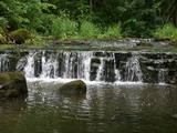 |
The ancient Abava River Valley between Kandava and the place where the river flows into the Venta River is the most expressive river valley segment in Kurzeme in terms of landscape and terrain. The valley is 30 to 40 metres deep and as much as 300 metres wide. The territory is distinguished by great diversity of a biological nature (more than 800 kinds of plants), featuring many different biotopes and natural monuments such as streams, waterfalls, cliffs, huge rocks, and many cultural and historical monumentssmall towns such as Kandava and Sabile. In both cases, the town centres are national monuments of urban construction. Popular tourist destinations include Vīnakalns hill in Sabile, where wine-making grapes are grown, as well as the open-air art museum at Pedvāle. To protect cultural treasures, a cultural and historical territory, “Abava River Valley” has been established. Wild livestock live at Drubazas and Tēvkalni to “maintain” the landscape. There are nature trails for tourists, and the Abava is the most popular river for water tourists in Kurzeme. Information is available at the tourist information centres in Kandava and Sabile. such as castle hills, churches, ancient burial grounds, and
|
|
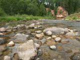 |
The Amata is one of Latvia's swiftest river, and water tourists congregate there each spring to engage in extreme activities. From the Rīga-Veclaicene highway, the Amata flows into a deep valley, with an average drop of more than 3 m/km or, downriver, as much as 8-10 m/km. Water tourists usually use the segment of the river between Melturi and the Zvārte cliff or the Veclauči bridge that spans the Līgatne-Kārļi road. Please remember that the Amata is not a friendly river for beginners. After lengthy rainfall, the river can be navigable during other times of the year, as well. The surrounding valley is attractive because of impressive sandstone and dolomite cliffs, among which the best known are the Vizuļi cliff (which can be the site of beautiful frozen waterfalls in winter), the Ainavu cliff, the Ķaubju cliff, the Dzilna cliff, the Zvārte cliff, and the Lustūzis cliff. Between Melturi and Veclauči, there is the Amata geological trail, which is marked with orange paint on tree trunks. There are three segments to the trail – from Melturi to the Kārļi fish farm, from the fish farm to the Zvārte cliff (both segments can be extreme!), and from the Zvārte cliff to the Veclauči bridge. You can hike the trail at any time except when there is deep snow. The most impressive views will be found when the trees are bare. If you boat down the river, you will not have time to look at or photograph the cliffs, because all of your attention will be focused on the river itself and the obstacles therein. |
|
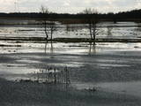 |
This is an open territory which is 3.5 km long and 2 km wide. It is located on the left bank of the Lielupe River between the village of Pavasari and the Odiņi homestead. The polder was established during the Soviet era to obtain farmland, and back then it was used very intensively. Today, it is slowly becoming overgrown, and despite this, this is one of the most important locations in Europe for corn-crakes. A gravel road crosses the polder from the North to the South, and this is an excellent place to hear the songs of the corn-crake. |
|
