
| No | Name | Description |
|---|---|---|
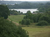 |
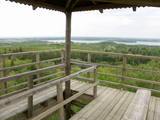
Latvia’s newest national park (2007) is in the “land of the blue lakes” – the region of Latgale. One of the goals of establishing a national park was to preserve the natural treasures of the region. Lake Rāzna, which is the second largest in Latvia, is there, as is Lake Ežezers, which has more island than any other lake in Latvia. There are other bodies of water, as well as typical landscapes of hillocks and a unique cultural environment. One of the most popular destinations in the park is Mākoņkalns Hill, which offers a lovely view of Lake Rāzna. Administrators of the newly established park are working on the tourist infrastructure – trails, routes, etc. Perhaps visitors would be advised to postpone their trip to the Rāzna National Park for awhile. |
|
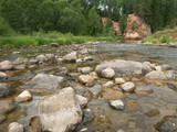 |
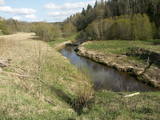
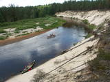
The Amata is one of Latvia's swiftest river, and water tourists congregate there each spring to engage in extreme activities. From the Rīga-Veclaicene highway, the Amata flows into a deep valley, with an average drop of more than 3 m/km or, downriver, as much as 8-10 m/km. Water tourists usually use the segment of the river between Melturi and the Zvārte cliff or the Veclauči bridge that spans the Līgatne-Kārļi road. Please remember that the Amata is not a friendly river for beginners. After lengthy rainfall, the river can be navigable during other times of the year, as well. The surrounding valley is attractive because of impressive sandstone and dolomite cliffs, among which the best known are the Vizuļi cliff (which can be the site of beautiful frozen waterfalls in winter), the Ainavu cliff, the Ķaubju cliff, the Dzilna cliff, the Zvārte cliff, and the Lustūzis cliff. Between Melturi and Veclauči, there is the Amata geological trail, which is marked with orange paint on tree trunks. There are three segments to the trail – from Melturi to the Kārļi fish farm, from the fish farm to the Zvārte cliff (both segments can be extreme!), and from the Zvārte cliff to the Veclauči bridge. You can hike the trail at any time except when there is deep snow. The most impressive views will be found when the trees are bare. If you boat down the river, you will not have time to look at or photograph the cliffs, because all of your attention will be focused on the river itself and the obstacles therein. |
|
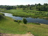 |
The Bauska Nature Park runs for several dozen kilometres along the Lielupe River and its tributaries – the Mūsa and the Mēmele. This is a protected territory. The shores of these rivers contain some of the largest dolomite cliffs in Zemgale. These are protected both as biotopes and as geological monuments. The rivers are important places for river lampreys and vimbas to spawn. Tourists will be attracted by the cultural landscape of the area, as well as the cultural monuments such as the Bauska castle, the Jumpravmuiža park, the Mežotne castle hill, Vīna Hill, the Mežotne castle, etc. The rivers are used for water tourism. |
|
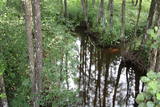 |
This territory is on both sides of the central section of the Raķupe River. On the banks of the river, there are many different meadow habitats, as well as massive oaks growing in the places of former farmsteads which are uninhabited by now. This is an important place for rare plants and animals. There is no tourism infrastructure for visitors in the area. Visitors who are especially interested in the environmental cognition are advised to visit the territory in attendance of experienced local guide. Raķupe is not usable for water tourism because of tilts of trees and beaver dams. |
|
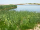 |
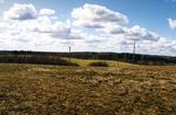
This area is full of coastline meadows, lagoons, muddy little lakes and sandy shallows, all full of reeds. This area of the eastern shore of the Bay of Rīga is found between Ainaži and Kuiviži. The Randa meadows are an enormously important location for water birds and rare plants – some 500 in all. A new bird-watching tower and a nature trail have been established for those who wish to study the meadows.
|
|
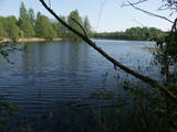 |
Dabas parks, kura lielāko daļu aizņem neprastās formas un līčiem bagātais Cārmaņa (arī Cārmins) ezers. Ezera ūdens ir ļoti tīrs, tādēļ tajā sastopamas Latvijai retas augu sabiedrības. Tā kā parka teritorijā nav tūristiem veidota infrastruktūra, interesenti var baudīt skatus, kas paveras uz ezera un tā apkārtni no Aulejas – Grāveru ceļa.
|
|
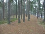 |
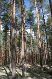
This territory is meant to protect the “green zone” of Rīga. Most of the park is covered with pine forest and dunes with shrubs on them, but Lake Beberbeķi is found at the southern end of the park. The area around the lake has been improved. |
|
 |
The Krustkalni Nature Reserve was established in 1977, and the diversity of plants in the region is based both on the terrain – the Madona-Trepe embankment, a series of hillocks with low areas among them, swamps and small lakes – and on the biotope – natural meadows, forest glades, places where underground streams bubble up to the surface, and vast areas of forest with very old stands of trees. Some 800 types of plants have been defined in the reserve. It can be toured only in the company of a guide from reserve headquarters, and one must apply in advance. Visitors can visit the Krāku streams, Lake Svēte-Dreimaņi, and other sites. |
|
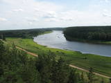 |
This nature park is one of the richest and most unusual nature parks in Latvia in terms of its natural resources, the surrounding environment, the landscapes, the biological diversity of the area, and the cultural monuments which are found there. The main treasure there is the little-changed Daugava River valley, where there are eight major curves in the river at a length of four to eight kilometres. There are also the gullies of river tributaries. Outstanding views can be found on the steep shores of the Daugava River valley, particularly the Slutiški and Ververi cliffs and the Elerne gravel hill. There are some 20 archaeological monuments on the shores of the valley -- ancient castle hills at Najene, Markova, Vecračina, etc., countless churches -- the Juzefova, Sprukti, Borovka, Elerne, Sīķele, Kaplava and other churches, the Rozališki, Lielborne and other baronia estates, and the unique village of Slutiški, which is home to the Old Believers. There are interesting nature trails and bicycling trails in the area. Horseback riding is available, and there is a viewing tower along with other elements for tourists. Boating down the Daugava River is an interesting way to spend time. |
|
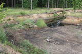 |
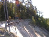
Nature restricted area has been established in old and overgrowing gravel pit and where rare species in Latvia - Natterjack toad (Bufo calamita) can be found. Natterjack toad needs open sand – gravel area therefore the population of it is decreasing once gravel pit is overgrowing by bushes. The population of this amphibian is depending on the activity of people in the area. There is very little chance to find Natterjack toad just by entering the restricted area, therefore please respect this area as especially sensitive.
|
|
 |
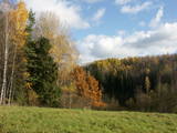
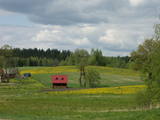
This area was established to protect the cultural and lake-related landscapes of the central section of the Vidzeme highlands, with Lake Alauksts, Lake Inesis, Lake Tauns, etc., with their species and biotopes. There are many important cultural objects in this territory – the Vecpiebalga Lutheran Church, the Vecpiebalga castle ruins, the Vecpiebalga baronial estate, as well as locations where several distinguished figures from the Latvian world of culture have lived and worked. Memorial museums have been established to commemorate them. The lakes are great for fishing, and cross-country competitions are traditionally held in the area of Lake Alauksts during the winter. The Sproģi nature reserve has been established on the islands and peninsula of Lake Inesis.
|
|
 |
Riežupes dabas parks veidots g.k. Riežupes izteksmīgās ielejas, tai raksturīgo dabas vērtību – nogāžu un gravu mežu, dažādu ģeoloģisku dabas pieminekļu - smilšakmens atsegumu, alu, ūdenkritumu, upes straujteču posmu, dažādu sugu, mežu masīvu un ainavas aizsardzībai. Parka atrodas viens no Kurzemes populārākajiem tūrisma objektiem – Riežupes alas - garākais mākslīgo alu labirints Latvijā, kura eju kopgarums ir 460 m. Sākotnēji dabas veidotās alas 19. gs. vidū mākslīgi paplašināja baltās smilts ieguves nolūkos, kuras izmantoja stikla ražošanai. Parkā izveidots velotūrisma maršruts. |
|
 |
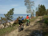
This nature park covers an area of the Baltic Sea coast and part of newly established sea protected area "Nida - Pērkone" with sand dunes which once used to move around but have now settled. These are the highest dunes in Latvia. Visitors will enjoy the coastal landscape, sandy beaches and small fishing villages of the area. A nature trail has been established on Pūsēni Hill (one of the highest dunes in Latvia) for those who wish to tour the nature park. |
|
 |
No ģeogrāfiskā un kultūrvēsturiskā viedokļa interesanta teritorija Latgales augstienes Rāznavas paugurainē, kuras nozīmīgākie resursi ir dažāda veida biotopi, ainavas, reljefs un Šķaunes ezers. Istras pauguraines dabas parkā nav ar tūrismu saistīti labiekārtojumi, bet šo teritoriju var apskatīt arī „no malas”, braucot pa grantēto ceļu no Soboļinas uz Osinovku, kas iet līdztekus parka ziemeļu robežai (skats uz Šķaunes ezeru).
|
|
 |
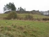
Samērā liela teritorija ar mozaīkveida ainavu - mežiem, atklātām ainavām un ezeriem (Salmejs, Kaučers, Stupānu ezers, Limanu ezers u.c.), kas atrodas Latgales augstienes Feimaņu pauguraines rietumdaļā. Aizsargājamo ainavu apvidus veidots šejienes dabas un kultūrainavas (apdzīvotās vietas, Tišas vecticībnieku lūgšanas nams, krucifiksi) un daudzveidīgo biotopu (t.sk. - sugu) aizsardzībai. Apvidū atrodas arī samērā populārs tūrisma objekts - Šnepstu pilskalns.
|
|
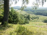 |
This territory was established so as to preserve the natural and cultural landscape of the most distinct part of the Alūksne highlands – a landscape which is made up of the highest hillocks in the area – Dēliņkalns Hill, Dieva Hill, Saules Hill, the Drusku castle hill, and the Kornetu-Peļļu sub-glacial river bed (one of the most significant terrain differences in Latvia). There are lakes, too – Lake Pilskalns, Lake Dzērve, Lake Ieva, Lake Raipals, etc. There are also significant biotopes – hillside and gully forests, various kinds of swamps and meadows, damp forests, etc., all with their own species of flora and fauna. There are nature trails and tracks for cross-country and downhill skiing in the area. There are three restricted natural areas in the territory – Korneti-Peļļi, the Avotu forest, and Dēliņkalns Hill. |
|
 |
The Svene Nature Park is in the central part of the Augšzeme highlands, and Lake Svente is at its centre. This is one of the cleanest lakes in Latvia. There is also Egļukalns Hill, which offers one of the most beautiful views in all of Zemgale from its viewing tower. Visitors can gaze at the hillocks and lakes of the Svente area. Egļukalns Hill also has ski trails and a nature trail. |
|
 |
This comparatively large territory is found to the South of the Irbe River and Stende River, and it is unique with more or less virginal forests and dunes. The Irbe River has a system of ancient tributaries, and the Dižpurvs swamp is parallel to the shoreline. The Irbe has become a popular river for water tourism in recent years, but the tourist infrastructure on its banks remains insufficient. Territory has good road connections and has potential for nature education activities. |
|
 |
The largest NATURA 2000 territory in Latvia covers 6% of the country’s area. It is located in parts of the Limbaži, Valmiera and Valka districts, and it is a place of an enormously diverse range of landscapes, biotopes and species. The Salaca River is one of the most important rivers in the entire Baltic Sea region in terms of spawning grounds for salmon. The river valley and its sandstone cliffs attract many visitors. It is no accident that this is the second most popular river in Vidzeme for water tourism. The shore of the Bay of Rīga, which is not very long, also features a great diversity in landscapes and biotopes. At the northern end, we find the Randu meadows. In the central part there are sandy beaches, but at the southern end – 22 kilometres of rocky shoreline. The so-called Northern swamps are found on the border with Estonia, while the Seda heath is one of the most important places in the region for birds to rest and feed during migration. The reserve also features a diverse forest in which one can find all of the types of forest which are common in Latvia. Nature trails and viewing towers or platforms are found in the Randu meadows, on the banks of Lake Burtnieks, along the Planči and Niedrāji-Pilka swamps, on the banks of Lake Dziļezers and Lake Lielezers, and elsewhere. The Skaņākalns park in Mazsalaca is one of the most popular tourist destinations in Northern Vidzeme. The territory boasts many important cultural monuments, including one of the earliest known settlements in Latvia – a fishing settlement and burial ground which date back to the 5th to the 2nd millennium BC.
|
|
 |
This is a stretched-out territory from Valmiera to the Ape Administrative District, and its primary “axis” is the unregulated Gauja River valley with a dense web of old rivers, park-like meadows of oak trees on their banks, and stands of oaks and other broadleaf trees. Many rare and protected birds, including corn-crakes, woodpeckers, wood grouses and others live and breed here. This is also one of the most important places in Latvia in terms of where the deciduous tree hermit beetle lives.
|
|
