
| No | Name | Description |
|---|---|---|
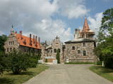 |
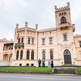
Cesvaine was first mentioned in written sources in 1209. For each traveller in Latvia, the town is associated with the family of Baron Woolf, who bought the Cesvaine estate in 1815. Cesvaine experienced the economic boom after establishment of Plavinas Gulbene railway. Town suffered significantly during the World War II. At the end of 2002, the Cesvaine Castle was struck by the tragedy - a fire, which damaged most of the castle. Cesvaine Castle is "recovering" by means of large public, state and local government support and still keeps the status as a significant tourism attraction in a scale of Vidzeme and Latvia. |
|
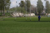 |
A small part of the impressive fortifications of Liepāja, these encircle the city’s perimeter and its shoreline. They’re found at the Olimpija stadium. See also Objects No. 30077, 30078, 30079, 30080 and 30098.
|
|
 |
The Museum of Francis Trasuns „Kolnasāta”. The museum of the promoter of Latgalian revival,
prominent cultural worker, pastor and politician F. Trasuns (1864 – 1926) was established in his house „Kolnasāta”. There is also an exposition about Jānis Klīdzējs; a collection of old household items. „Kolnasāta”
is the place of many cultural events in Latgale.
Working hours: Mon– Fri : 8.00 - 16.00, Sat., Sunday : on request |
|
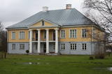 |
Muiža rakstos pirmoreiz minēta 17. gs. sākumā, taču klasicisma stilā celtās pils veidols tapis 1835. gadā. Penijē muižas būtisks likteņa pavērsiens (atšķirībā no daudzām citām muižām) bija apstāklis, ka tajā izveidoja Matsalu rezervāta (pirms nacionālā parka izveides) apmeklētāju centru. 2000. gadā muižas pili restaurēja un tajā ierīkoja nelielu ekspozīciju. Apmeklētāju centrs te pastāv joprojām, tādēļ šeit var iegūt nepieciešamo informāciju. No ārpuses var apskatīt arī citas muižas saimniecības ēkas. |
|
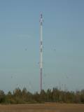 |
This is the only Soviet military object of its type and scope in Latvia – a long-distance communications base which was supposedly used to maintain contacts with Soviet naval ships and submarines all around the world. The facility had a central tower and six perimeter towers, each more than 200 metres high. Some of the towers remain in place and are used for mobile communications. It is rumoured that the Soviet communications system was never once turned on. The complex at Upīškalns can be seen by driving down the Skrunda-Kuldīga road. It is some 3 km before the Kuldīga ring road, at a populated location called Raidstacija.
|
|
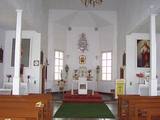 |
Holy Trinity Parish Catholic Church of Strūžāni was renovated
and sanctified in 1958. The church has no towers because they were not allowed in the time of the Soviet
Union.
|
|
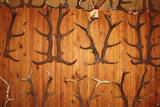 |
Found at the Purvziedi homestead in Vaide, this collection of more than 600 horns has been established by forest guard Edgars Hausmanis, who says that he found all of the exhibits in the forest. |
|
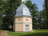 |
The creamery or clock tower (so known because a clock was installed in the round roof window of the structure) is near the gate to the Naukšēni Estate. The eight-corner brick building has a domed roof that is covered with tin. The clock tower has two floors. The second is easily ventilated because of small windows on all sides of the building. The creamery is seen in a picture drawn by J.K. Brotze around 1800. It suggests that the building has not lost its initial shape even today. The tower deteriorated during the Soviet era, when a barn was attached to it and a large gate opening was broken into it. In 2002, the tower was renovated (architect Inese Maurāne). The interior preserves the historical brick floor and the stairs to the second floor. Historical objects are displayed in the creamery, and today it is one of the main tourist attractions for the Naukšēni Estate. |
|
 |
The castle was commissioned by Baron Alexander von Fittinghof and built between 1859 and 1863 in the late Tudor Neo-Gothic style. It is one of the most important monuments to this style in Latvia and has an ornate limestone façade. The 7th Sigulda Infantry Brigade was housed in the castle from 1921 until 1940. Today it is home to the Alūksne Museum with a permanent exhibition and an “environmental labyrinth.” One of the most unusual exhibits is a set of fluorescent minerals that can be viewed under lights with various spectrums. |
|
 |
1275 is considered as a year of foundation of Daugavpils. This is the time when the Master of Livonian Order Ernst von Ratceburgs built Dinaburg castle at the Naujene hill fort. It suffered several Lithuanian and Russian invasion until in 1577 the castle was destroyed by Russian troops under the command of Ivan the Terrible. After this event Dinaburg was restored 17 km further on the right bank of the river, where now the town of Daugavpils is located. From 1810-1833a new fortress was built. In 1826 started the building of what is now the historic centre of the town. During the World War I the major industrial companies with workers were evacuated to Russia. During first Latvian Republic, the cultural life in Daugavpils flourished. Most part of the town was destroyed during World War II – in the July of 1944. Nowadays the town is the second largest town in Latvia and is an important economical centre of Latgale historic region. Restoration of Daugavpils Fortress was launched recently; this project can be considered as a unique on the European scale. |
|
 |
The Smārde saloon has a very long history,
and food is served here. There is a car park, and
approx. 100 m to the East is a cemetery and
monument to commemorate soldiers who fell
during World War II.
|
|
 |
In Limbazi, in the crossroads of Cesu and Dailes streets, there is a monument dedicated to the author of Latvian anthem. The monument was designed by the sculptors Zigrīda Rapa and Juris Rapa. It was unveiled on May 16, 1998, when Limbaži was celebrating its 775th anniversary. |
|
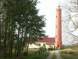 |
The lighthouse at Akmeņrags supported maritime navigation in Soviet times. Today it is controlled by the Latvian Maritime Administration. The lighthouse is open for visitors.
|
|
 |
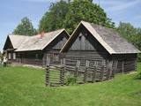
Salos, Vaišnoriškė, Strazdai, Šuminai sind die bewohnten Dörfe im Augštaitija- Nationalpark, in denen historische Einzelgehöfte mit Holzgebäuden erhalten sind. |
|
 |
Atrodas 0,9 km ziemeļrietumos no Dzērbenes centra. Tagadējais muižas komplekss veidojies 14. gs. celtās un 1577. g. nopostītās mūra pils vietā. Muižas pils (18. gs. beigas, klasicisma stils) savā pastāvēšanas laikā piedzīvojusi vairākkārtīgu nopostīšanu (1905. g., Pirmajā pasaules karā) un tai sekojošu atjaunotni. 19. gs. beigās tai tapa piebūve – iespaidīgs četrstūru neogotikas stila tornis. Laikā no 1927. - 1975. g. pilī darbojās lauksaimniecības skola, tagad - Dzērbenes pagasta pārvalde, Tautas nams un mūzikas skola. Pili ieskauj parks ar septiņu dīķu kaskādi. No kādreiz iespaidīgā laukakmeņu žoga saglabājušies vien pils vārtu stabi. Dažādā stāvoklī (arī avārijas) atrodas citas muižas ēkas. 2010. gadā tika veikta pils iekštelpu un ārējās fasādes restaurācija. Iepriekš piesakoties, tiek piedāvāta gida vadīta ekskursija un piedzīvojums muižā iekārtotajā spoku kambarī. |
|
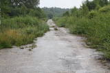 |
One of the largest tank bases in the Baltic War District was located during Soviet times just South of Gardene. The territory has largely been abandoned, and there are just a few remnants of the buildings that were once there. If you drive down the Dobele-Annenieki road, you will find a paved military road splitting off from it. It is still used today. The buildings and urban planning of Gardene are also of interest – during the Soviet era, soldiers and their families lived there.
|
|
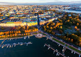 |
Helsinki is the capital of Finland and the biggest city in Finland. It offers a lot to see as it is seaside city surrounded by islands but city itself is full of wonderful parks. This city has everything to attract all kinds of people - from architecture and culture to nature and even has wide range of places where to enjoy night-time Helsinki. |
|
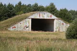 |
There are still some buildings, missile silos and an apartment building from the old No. 158 Zenith Missile Base at Ziemupe, but the territory has been abandoned and degraded.
|
|
|
|
This village is at the place where the Irbe (Dižirve, Īra) River flows into the sea, and it is on both shores of the river (sea side and land side). The name of Irbe was recorded for the first time in a 1310 border agreement between the bishop of Kurzeme and the Rīga Dome Capitol. The name of Lielirbe (Irvemūnde) was recorded for the first time in a document from an arbitration court in 1387. At the end of the 19th century, the small port at Lielirbe was an active centre for the sale and transport of timber materials. In the late 19th and early 20th centuries, the largest number of sailing ships among villages on the western shore of Kurzeme was built there. In 1939, the village had some 300 residents, more than 70 houses and a Baptist church which is now at the Ventspils Open Air Museum. A narrow-gauge railroad passed through the village, which had a post and telegraph office, two grocery stores, an elementary school, a choir and a brass band. Lielirbe was one of the largest villages to disappear after World War II. Cultural historian Valda Marija Šuvcāne (1923-2007) was born in Lielirbe, and her daughter, Baiba Šuvcāne, is continuing her mother's work by writing important papers about life along the Livonian coastline. By 2019, a bridge is to be reinstalled across the Irbe River. |
|
 |
Atrodas Rucavas – Bārtas ceļa malā (pagrieziens uz Bārtas Romas katoļu baznīcu). Veltīts melioratoram Arvīdam Manfeldam – bijušā Liepājas rajona meliorācijas uzņēmuma priekšniekam kā pateicība no vietējiem iedzīvotājiem par ceļiem un tiltiem. |
|


