
| No | Name | Description |
|---|---|---|
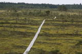 |
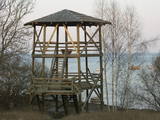
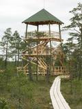
The tower is in the western part of the Vasenieki swamp, and an interesting nature trail with information stands and pathways was recently established there. The tower offers a look at unique swampland – visitors can survey the entire swamp. Wear proper footwear when it is damp outside!
|
|
|
|
Atrodas Cenas tīreļa dabas takas sākumā. No tā labi pārskatāma kūdrā izstrādātā Cenas tīreļa neliela daļa. |
|
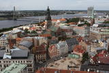 |
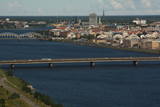
St Peter’s is one of the oldest historical monuments in the Baltic States, and it is also the best place from which to survey the historical centre of Rīga, which is part of the UNESCO list of world cultural heritage. You can see the central part of Old Rīga, City Hall Square, the Pārdaugava region on the opposite side of the river, and even – during clear weather – the Bay of Rīga. The tower of the church is 123 metres high, but the viewing location is at a height of 72 metres.
|
|
|
|
Meklējams pie Gulbjiem – Dvietes senlejas informācijas centra. No torņa labi pārskatāma ūdeņiem bagātos pavasaros pārplūstošā Dvietes paliene, dzīvei savvaļā pielāgoto mājlopu aploki un izlīkumotā Dvietes upīte. |
|
|
|
Atrodas Skuķu ezera ziemeļaustrumu krastā. No torņa labi saskatāms aizaugušais Skuķu ezers ar nelielām ūdens lāmām un ūdeņiem bagātos pavasaros pārplūstošā Dvietes paliene. Laba putnu vērošanas vieta. |
|
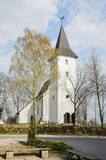 |
The Priekule Lutheran Church was built around 1680 and rebuilt a century later, in 1892. In 2005, the church tower was improved, and visitors to the church can now use it as a viewing platform. They can see the place where Icarus of Priekule supposedly made his first “flight.” |
|
|
|
Atrodas Zebrus ezera austrumu krastā pie Latvijas Valsts mežu laivu bāzes. No torņa labi pārskatāms Zebrus ezers, ziemeļu virzienā – Ezerlūķu pilskalns. Laivu bāzē – atpūtas vietas. |
|
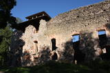 |
The ruins of the Rauna castle (which was built in 1262 and was a main residence of the Livonian archbishop) have a modern viewing tower which offers a view of the impressive castle walls, the place where the former Medieval city was located, and the centre of Rauna. The local government office has the keys to the tower.
|
|
|
|
2015. gadā uzceltais skatu tornis atrodas dabas parkā „Daugavas loki”, Daugavas ielejas kreisajā krastā – Daugavpils novada Vescalienas pagastā. No torņa aplūkojama izcilā Daugavas loku ainava. |
|
|
|
Meklējams Zirgu salas dienviddaļā – uz t.s. Golodova dambja. Tornis pieejams kājāmgājējiem un velobraucējiem. Automašīna jāatstāj pie Ezermalas ielas. No torņa redzams plašs skats uz daļēji aizaugušo Liepājas ezera ziemeļdaļu. Laba putnu vērošanas vieta. Ietilpst Liepājas ezera dabas lieguma teritorijā. |
|
|
|
Uzcelts Kaņiera pilskalnā un ir Kaņiera pilskalna takas sastāvdaļa. No torņa paveras izcila Kaņiera ezera dienvidrietumu daļas ainava ar niedru saliņām un nelieliem atklāta ūdens laukumiem. Laba putnu vērošanas vieta. |
|
 |
The tower is locatede in the Niedrāji-Pilka swamp. Access it via the old Ainaži-Valmiera-Smiltene narrow gauge rail line, which dates back to 1912, and then take the wooden footpaths which are approximately one kilometre long. This is a high-type swamp with small lakes at the foot of the tower. It is in the ZBR. |
|
|
|
Atrodas Sedas purvā (Sedas dabas takas malā) ar plašu skatu uz izstrādātajām kūdras platībām. Sedas taku ieteicams izstaigāt vietējā gida pavadībā T: + 371 2636162. |
|
 |
This tower is on the shores of the ancient Litorine Sea, with a lovely view of the unique seashore here – complete with small bays and capes. It is part of the Kaltene nature trail, which is around one kilometre long. The location is of particular interest during spring or autumn migration of birds. Two other bird-watching platforms are nearby.
|
|
 |
This 368 metre structure is the highest television tower in the European Union. Its viewing area, which is at a height of 97 metres, is the highest publicly available viewing area in Latvia. The location offers a fantastic view of Rīga and Old Rīga to Pārdaugava, the Bay of Rīga and Sigulda – a radius of at least 50 kilometres.
|
|
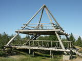 |
This is the only viewing platform of its kind. It is north of Pāvilosta, between the sea and Latvia’s largest gray dune. The second level of the platform offers a good view of the habitats which surround the dune, as well as the seashore and the largest seashore rock on the shores of the Baltic Sea – the Pāvilosta sea rock. You can also see the northern part of Pāvilosta. When it is windy outside, you’ll see kiteboard riders showing their tricks.
|
|
 |
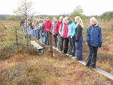
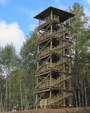
This is part of a hiking trail along the Cena bog. It is on the western side of the bog, at the centre of the 5-kilometre circular trail. You can see the vast swamp, as well as a military road that was installed during World War I and is marked by an “alley” of large pine trees. Alongside the tower is a fragment of the road that was installed more recently.
|
|
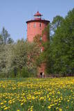 |
is the second oldest navigation structure in Latvia and the only one that is five kilometres from the shore, at the upper edge of the ancient Lake Baltic Ice. Since 2000 the lighthouse has not served its initial purpose, and now it is the home to the Nature Education Centre "Slītere" of the Slītere National Park. The centre offers exhibitions about lighthouses in Latvia and the history of the Baltic Sea. From the upper floor (102 m above sea level) one can see the coast of Saaremaa (approximately 33 km away). Alongside the lighthouse is the 1.2 km Šlītere nature trail. |
|
 |
Atrodas Numerenes dabas parka teritorijā. 20 m augstais tornis uzbūvēts uz t.s. Numerenes vaļņa, no kura paveras plaša ainava un aizaugošām lauksaimniecības zemēm un nelielu mitrāju ar Kugreņa ezeru austrumu virzienā. Torņa apkaimē izveidota izziņas taka. |
|
|
|
No 28 m augstā torņa, kas atrodas uz apdzīvotas „salas” – Siksalas Teiču purva vidū, paveras ļoti plaša augstā purva ainava ar Siksalas ezeru, citām minerālzemes salām un Siksalas mazciemu. Tā kā tornis atrodas Teiču dabas rezervātā, to var apmeklēt tikai Dabas aizsardzības pārvaldes inspektora pavadībā, iepriekš piesakot vizīti T: + 371 28333415. |
|
