
| No | Name | Description |
|---|---|---|
 |
The trail informs visitors about one of the loveliest natural habitats in
|
|
 |
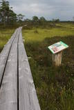
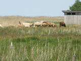
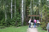
This path is found on the right bank of the ancient Abava river valley. The visitor will be able to view places where underground streams create wetlands, various kinds of meadows, a stand of juniper bushes, etc. The area is “managed” all year long by “wild” cows. The shore of the ancient valley can be climbed (some 200 steps), and the view is magnificent. It is recommended that the trail be visited in the company of a knowledgeable guide. There is a shorter path that is 600m long, along with a longer one that is more than a kilometre in length. It will take an hour or so to traverse it. Objects are found in the ancient Abava valley nature park.
|
|
 |
Labiekārtota (informācijas stendi, atpūtas vietas) un marķēta taka, kas ved apkārt Kokšu ezeru virknei, kurā ietilpst Zāļu, Dziļais un Dibena ezers. Iepazīstami mežu biotopi, dzīvnieki un to darbības pēdas. Iespējami trīs dažādi takas izziešanas varianti: 7 km, 4,5 km, 2,7 km. Maršrutu var braukt ar divriteni. Ietilpst Ziemeļvidzemes biosfēras rezervātā. |
|
 |
A pathway of wooden trails and little bridges, featuring the most beautiful part of the Ieriķupīte river, with several waterfalls, an old windmill, a unique millwheel, and various areas of obstacles for active people in the company of a guide.
|
|
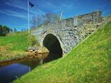 |
Takas sākums atrodas Vidagā, vietā, kur uz Vizlas celts vēsturiskais akmens arkas tilts. 1,2 km garā taka bez marķējuma ved gar pašu upes krastu līdz pat ietekai Gaujā. Redzami skaisti dolomīta atsegumi, nelieli krāčveidīgi ūdenskritumi un iespaidīgais Žākļu dižakmens. |
|
 |
Overgrown with reeds, full of seashore meadows, lagoons, muddy little lakes and sandy shallows – this is the part of the Bay of Rīga shoreline which runs between Ainaži and Kuiviži. The Randi meadows are an important location for birds and plant life. It is a protected habitat with environmental restrictions. A bird-watching tower and nature trail have been installed so that visitors can study the meadows. The tour will take around one hour to complete. Objects are in the Northern Vidzeme Biosphere Reserve.
|
|
 |
Lots of wild animals can be found in vast paddocks along the ancient Gauja river valley and its small tributaries – areas in which living conditions are as close to natural circumstances as possible. Here the visitor can find, if lucky, reindeer, deer, wild boars, bears, foxes, lynx, various kinds of birds, as well as aurochs. There is a dense network of pathways in the park, including lots of information. There is also a route for drivers and bicyclists. During the winter, it is used for distance skiing. There is also a visitors’ centre.
|
|
 |
Folkloras taka "Jāņkalni" iepazīstina ar mūsu senču rakstiem, zīmēm un dievībām, kas ir mūsu folkloras mantojums. Folkloras takas (garums: apm. 1,5 km vai 2 stundas) mērķis ir arī iepazīstināšana ar senlatviešu ieražām, folkloru, kā arī tautu dainu izprašana. Piedāvā iziet Latvijas karti - labirintu ar 19 etnogrāfiskajiem novadiem. Gids Jums sniegs izsmeļošu stāstījumu un atbildes uz interesējošiem jautājumiem.
|
|
 |
Teritorijas apskates nolūkos ir izveidota un labiekārtota dabas izziņas taka. Dabas liegums atrodas Abavas senlejas dabas parka teritorijā. Taka iepazīstina ar vienīgo krūmu čužas savvaļas augšanas vietu Latvijā. |
|
 |
Brīvdienu mājas "Korķi” apkārtnes priežu mežā ir izveidota Jāņtarpiņu taka. Ideāla vieta aktīviem sēnotājiem un ogotājiem. Savukārt saules un jūras cienītāji pa šo taku 5-10 minūšu gājienā nonāks Vitrupes pludmalē, kur varēs baudīt sauļošanās un peldēšanās priekus.
|
|
 |
Dabas liegumā "Pilskalnes Siguldiņa" ir izveidota dabas taka - kājinieku tūrisma maršruts – t.s. Augšzemes ainavu taka, kas sākas Pilskalnē un beidzas pie Driģeņu mājām. Tā izlīkumo ezeru krastus, šķērso purvu (laipas). Apmeklētājiem, t.sk. arī bērniem, izveidotas arī īsākas - lokālas takas. Pieejami dažādu taku garumi: 1,6 km, 3,8 km, 8 km. |
|
 |
This is an uncommon trail. The visitor will learn all about quite “ordinary” trees such as the oak, the linden, the hazelnut, the fir and the pine. The information is quite interesting, however, making use of the heritage of Latvian folklore. The site is located near the Zvārte rock. Visitors will spend around one hour on the trail.
|
|
 |
Takas sākums atrodas pie Veclaicenes pagasta pārvaldes (autosvālaukums). Tā izlokas gar Ievas, Trumulīša un Raipala ezeru dienvidu krastiem un pa ziemeļu krastu nogāzēm atgriežas atpakaļ sākumpunktā. Apļveida takas garums – ap 8 km. Atrodas Augšzemes aizsargājamo ainavu apvidū, Kornetu – Peļļu subglaciālajā vagā. |
|
 |
Dabas parkā izveidota Baltijā vienīgā Bišu taka, kurā apmeklētājs var iejusties bites ‘’lomā’’. Zinātkārie var ieģērbties bitenieka tērpā un novērot bišu dzīvi stropā vai kāpt kokā ar seno dravnieka ierīci – dzeini. Ekskursija, Bišu, Putnu, Meža, Sporta un Augu takas. |
|
 |
Dabas taka atrodas Zaķumuižā un ved cauri vecajam muižas parkam, pa ceļam iespējams aplūkot simtgadīgus kokus, dažādus augus, kā arī dažādus kukaiņus, putnus. Taka ir veidota kā mācību taka un to veidojusi Zaķumuižas pamatskolas skolotāja. Taka ir 1,5 km gara. Tai ir vidējas grūtības pakāpe: takas reljefs ir samērā vienmērīgs, mērens, izņemot atsevišķus posmus (daži stāvumi un kritumi, dažviet nelīdzens reljefs), tāpēc īpaša fiziska sagatavotība pirms takas iziešanas nav nepieciešama. Vietās, kur reljefs ir stāvāks, izvietoti roku balsti, bet pāri muižas dīķu sistēmas ūdeņiem uzcelti divi tiltiņi.
|
|
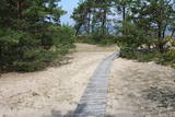 |
The trail (the length 1.2 km) introduces with the habitats of dunes and century-old pines, partly covered with sand. Biologists estimate that the oldest tree, the “mother of pines”, could be around 200 years old. Coastal pine forests serve as a barrier between the sea and land protecting inland areas from impact of the sea and winds. Felling coastal forests was forbidden by law already back in 1643, during the Duchy of Courland. Still due to economic activities, the seashore forests were often fell and fires occurred there occasionally. As a result, the sand which had for centuries been hold by trees, started drifting at Cape Kolka. In the 1930ies, there were about 142 hectares of sandy areas in the Slītere National Park, and 11.5 hectares of those were drifting sand. To stop drifting, the sand areas were carefully afforested. Afforestation was started before WW I and it was completed in the 1970ies. To plant new trees, first the sand had to be stopped. Just 26km to the south from Kolka there was one of the largest sand dunes in Latvia, 25km in length. Every year it devoured 0.3 hectares of land. The sand was stopped covering it with heather, twigs and branches of pines and junipers. Pine trees were planted between them. Today in Kolka, the old, low pine trees tell about the once drifting sand. After storms, when the water washes the bluff and tree roots are exposed, one can see that the tree trunks once have been covered with sand more than 1 meter high. The trees on the seacoast usually have crooked trunks and flag-shaped crowns formed under influence of persisting sea winds. Now these forests are designated biotope “Wooded dunes of the coast”. Stable white dunes (biotope 2120) do not form in Cape Kolka as they are washed by sea waters during spring and autumn storms. Embryonic dunes develop here (code 2120) with plants that usually grow in dunes. These plants have adapted well to poor soils, heat, drought, and the saline sea water. The Kolkasrags Pine Trail is in Slītere National Park. |
|
 |
One of the few places in Latvia where there are so many well-organised pathways. The region is known for castle hills, the location where the great Latvian author Anna Brigadere (1861-1933) lived and worked, the storybook character figures that are scattered around that area, a great forest, an arboretum, a museum of history, a viewing tower, landscapes, etc. This has been recognised as the most family-friendly place in the country.
|
|
|
|
Atrodas mežā, netālu no Kaltenes. Labiekārtota (laipas, kāpnes, informācijas stendi) taka, kas iepazīstina ar Latvijai samērā neparastu dabas pieminekli (aizsargājams) – Kaltenes kalvām, kas ir lieli, līdztekus Rīgas jūras līča krasta līnijai orientēti laukakmeņu krāvumi. Uzskata, ka tos veidojuši Baltijas ledus ezera ūdeņi un ledi. Garums – ap 1,5 km. |
|
 |
This circular trail features a unique landscape of parallel rampart-type sand dunes and grassy swamps among the dunes. The 3.5 km trail leads through a landscape that is unique in Europe and emerged some 6,000 years ago as the sea was receding. This landscape offers evidence of the geological history of the Baltic Sea. There is a high-type swamp (the Pēterzers swamp), along with remnants of an old narrow-gauge railway. Wooden pathways have been installed along the swamp and the surrounding wetlands. |
|
 |
This is a trail for hikers and bird-watchers, located in a very interesting place on the shore of the Bay of Rīga near Kaltene. The visitor will see small inlets and capes and a rocky or overgrown shore. At the end of the trail there is a bird-watching tower. During the spring and autumn migrations of birds, the visitor will see a great many different kinds of birds in the area – geese, plovers, etc. The length of the track is a bit more than one kilometre, and it will take 20 minutes to an hour to cover.
|
|
