
| No | Name | Description |
|---|---|---|
 |
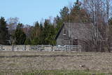
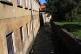
The town's name in historical sources was first mentioned in 1224. In 1340 Archbishop of Riga built a stone castle at the Latgalian hill fort (now - the Lutheran Church). In 1802 (owned until 1920) Vecgulbene estate was bought by Baron G. Wolf. Manors in the surroundings of Gulbene and Vecgulbene castle substantially suffered during the Revolution in 1905 and in the further historical events. Today, there is a substantial change in the landscape, especially in the area of White Castle, where a large-scale restoration works occurred in recent years. Either way, - Gulbene is the place worth visit to get new impressions and knowledge. |
|
 |
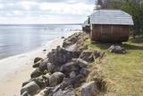
This village appears in historical documents from 1310. A census in 1582 and 1583 recorded eight farms in the village, while a 1731 census conducted by the Dundaga Estate found only three. In 1826, each farm had 16 or 17 people, with some 60 in total. A census in 1935 showed that all 49 Livonians in Saunags spoke the Lithuanian language, but only 11 of them spoke the language at home. There was a store that was owned by Kārlis Tilmanis, who also owned a factory where sprats were salted. Also born in Saunags was the seafaring captain Arvīds Ludeviks (1912-1996). In May 1945, he captained a tugboat, the Rota, in an attempt to bring Latvian refugees to Sweden. The ship was detained, and the captain was sent to Siberia. Another seafaring captain from Saunags was Visvaldis Feldmanis (1938-2017). |
|
|
|
The town of Subate was first listed in documents in 1570, when Duke Gotthard Kettler of the Duchy of Courland sold the Subāte marketplace to Count G. Plater-Sieberg. When the Plater-Sieberg dynasty converted to Catholicism in the mid-17th century, Lutherans in Subate protested by moving to the eastern bank of Lake Subate. That was the property of the Prode Estate (only ruins remain at this time), which was owned by the Osten-Sacken dynasty. In 1685, the Osten-Sackens built a Lutheran church for the “refugees,” and Jaunsubate was established around it. Both parts of the town were merged again in 1894. During Latvia’s liberation battles in 1919, Subate was liberated by Lithuanians, at which time the town was divided up between Latvia and Lithuania (though the border between the two countries was set at the previous line in 1921). The historical centre of Subate was established between the 16th and the 19th century, and it includes four churches for various congregations and low wooden buildings which stretch along narrow and curvy streets. The town is on the shores of a sub-glacial depression with Great Lake Subate and Lesser Lake Subate therein. This provides the town with unusual landscapes for Latvia. |
|
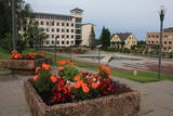 |
Madonas centrālais laukums, kas vēl 20. gs. sākumā bija tirgus laukums. Pēc apjomīgās restaurācijas tas ir kļuvis par ievērības cienīgu pilsētvides objektu. Laukuma ziemeļu pusē atrodas pilsētas un novada pašvaldība un Madonas novada TIC. |
|
 |
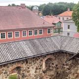
"The heart of Latgale", where during the 9th – 12th century stood a fortified Latgalian castle. In 1285 Livonian Order began the construction of stone castle instead of Latgalian castle. After the collapse of Livonia (Rezekne in the composition of Poland) the city languished. Economic life in Rezekne restored in the second half of the 18th century. After the construction of St. Petersburg – Warsaw highway (1836) and railway (1861), Rezekne became a holiday destination for holidaymakers from St. Petersburg. During the World War II, buildings of the city significantly suffered. Today the town is an important economic and cultural centre of Latgale region. |
|
 |
Krustpils was first recorded in documents in 1237 in relation to the construction of the Kreutzburg castle on the right bank of the Daugava River. A 1511 document lists it as a village. In 1585, Polish King Stefan Báthory gifted the town to Nicholas Korff, whose family continued to own it until 1920. Battles between Swedish and Polish forces occurred outside of Krustpils in 1626, and the sacked village was in poor shape until the mid-19th century. Jēkabpils, in turn, was constructed as a settlement for Old Believers who were persecuted in Russia. The Daugava has rapids opposite Krustpils and Jēkabpils, which means that boats had to dock there and reload their goods into wagons. The settlement flourished, and in 1670 it was given the rights of a city. It is named after Duke Jacob. When the Rīga-Daugavpils rail line opened in 1861, Krustpils flourished, and Jēkabpils did not flourish. The two cities were administratively merged in 1962, keeping the name of Jēkabpils. There are typical one-story wooden buildings from the 19th century, red brick buildings built at the turn of the 20th century, as well as seven churches used by different denominations. The dam along the left bank of the Daugava was built in 1861, and it was aimed at protecting the city against flooding. Today it is a promenade that is popular among local residents for strolling and leisure. |
|
|
|
Eine Floßhauptstadt Lettlands mit dem jährlichen Flößerfest im Mai. |
|
 |
This is a unique small town in a certain sense, and it is the only one in the Baltic States which has remained in place since the 17th and 18th century. The town is around the small Alekšupīte River, and in some places the stream runs along the walls of the buildings. Because of this fact and the many bridges that are in town, Kuldīga has become known as “the Venice of Latvia.” Baznīcas, Liepājas, Kalna and other streets are full of interesting cultural monuments. |
|
 |
Mulgima or Mulgi is a cultural and historical region in the south of Estonia. The part of Viljandi county located south of the rivers Raudna and Tenasilma was considered to be region of Mulgimaa. In ancient times, Mulgi farmers were famous for their sharp minds and determination, which helped to buy land from German-Baltic nobles and become rich farmers. The icons of Mulgi culture - the dialect, the well-known men's long black jacket and the traditional Mulgi porridge - have survived to this day. |
|
 |
It is believed that at the Kezberkalnins of Limbazi has been Lemisele castle of Metsepole Liv district. It is also found in the reports that merchants travelled to this place from the sea by Svētupe and Dunezers until the 16th century. In 1223 Bishop Albert built a stone castle in Limbazi. Like Valmiera, Limbazi became the member of Hanseatic League. At the beginning of 16th century it economic role declined significantly since Svētupe and Dunezers became unusable for shipping. Between the 16th and 18th centuries, the town and its people suffered from wars, diseases and fires. As a result, the population reached its utmost fall - eight people. In the turn of 19th and 20th century and in the beginning of 20th century the economic life of the town was renewed. |
|
 |
Dundaga baron once was one of the largest landowners of Courland, therefore during the second half of 19th century around the estate formed centre of economic and social life. Dundaga Central Square is dominated by its water tower, behind which starts Dakterleja, where from 1844 to 1854 worked one of the first ethnic Latvian doctors and linguist, J. Bars. Until the sixties of the 20th century from the Dundaga through Mazirbe and fishermen villages to Ventspils ran a Narrow gauge train. Today Dundaga attracts tourists with its spectacular castle, the Lutheran church, crocodile sculpture, Eizenberga pottery workshops and other objects. |
|
 |
This is an ancient Liv village, known as Mustanumm is the last village in the south-easterly direction, and during the mid-20th century, just a few Livonians lived there. Of 307 inhabitants in 1935, only 15 were Livonians. At the beginning of the 19th century, there were six farms and a lagoon here, but at the end of the century there were 63 farms. The valley of the Baķupīte River and the sea had remnants of pilings that provided evidence about a Medieval port. Legends say that the sea robber Trommel had a castle on the left bank of the river during the 14th century. Sailing ships were once built in the region, as well. Two locations of cultural and historical importance in Melnsils are the ancient cult location that is the Baķi castle hill, and the castle hill of a sea pirate Trommel. |
|
|
|
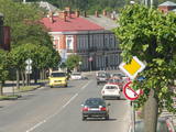
One of the oldest towns in Latvia, about which data can be found already beginning from 1378. As a populated area it formed at the banks of the Tebra River (the side of Riga-Prussia road), where once the fortified wooden castle Beida of the Cours Land Bandava was located. In the medieval times Aizpute was the centre of Kurzeme bishopric. After joining Kurzeme to Russia in 1795, Jews settled for living in Aizpute. Today travellers in Aizpute are most attracted by the ancient city environment that is still alive here, as well as by the historical centre of the city and the castle ruins. |
|
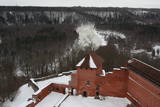 |
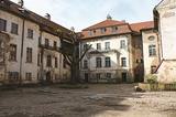
Construction of the Sigulda castle was begun by the Order of Brethren of Swords in 1207, but in 1236 it was rebuilt for the needs of the Livonian Order. The building suffered much damage during wars in the latter half of the 16th century and the early part of the 17th century. It was burned down during the Great Northern War and was not restored. Visible today is the south-western wing of the castle’s convent building and the main gate tower, behind which is the internal forecastle with an open-air stage that offers an impressive view of the ancient Gauja River valley. The new Sigulda castle was built between 1878 and 1881, and it was owned by Count Kropotkin. From 1923 until 1940, the castle housed a centre for writers, and during the Soviet Union it was a hospital for cardiology patients. Since 2003, the Sigulda Administrative District Council has been located here. The buildings that have been preserved include a wooden home (mid-19th century), where the Kropotkin family used to live, a granary (late 18th or early 19th century), the home of the gardener (19th century) and a brick wall (19th century). If we go to the north-eastern direction, we will find the Vējupīte valley less than two kilometres away. It includes the shallow (3.6 m) but high (6.1 m) Pēteris cave and the deep Pūču valley with the little Kraukļupīte River. At the place where the two valleys come together we find the Satezele castle hill (its flat surface is 90 x 75 m), where, in the early 13th century, the oak castle of the ruler of Livonian lands, Dabrelis, was once found. Nearby is the Kraukļu valley, with 11 m sandstone walls and a cave that is 5.2 m deep. Nearby is the Paradise (Painter) hill, which offers a lovely landscape that has been painted and photographed since ancient times. There is a Ferris wheel in the western part of Sigulda that is open during the summer, as well as an aerial tram that is the only transport vehicle of its type in the Baltic States and was installed in 1969. The cable that carries the tram is 1,060 metres long and links the shores of the ancient Gauja River valley between Sigulda and Krimulda. The cable is approximately 40 metres above the Gauja. The south-western part of Sigulda features the mighty Beite cliff which is split by a deep stream valley. To the west of the cliff is the Emperor’s View viewing area that is 67 m above the Gauja and offers a good view of Krimulda and the Turaida Castle. A viewing area was established here in 1862, when Tsar Alexander II of Russia visited Sigulda. The wooden Emperor’s chair is to the east of the viewing area. The Turaida Museum Reserve is in the place where the shore is split by deep valleys carved out by streams. It features several outstanding monuments that are as much as 1,000 years old. Of note are the Turaida Estate (21 buildings), the grave of the Rose of Turaida, the Turaida Lutheran Church (1750), which is one of the oldest wooden churches in Latvia) and the Turaida Castle. Folksong hill, which is nearby, is used for various thematic events. |
|
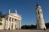 |
The Capital of Lithuania. One of the biggest East Europe's old towns (included in UNESCO World's Cultural Heritage list) where there is a lot of representation of various architecture styles like Classicism, Baroque, Gothique, etc. |
|
 |
Was mentioned in 1387, where it was called Domesnes. That was the name until the early 20th century. A ledger at the Irbe-Ģipka church states that there were four farms in Kolka in 1770 -- Krogi, Ūši, Vecvagari and Kabriki. In 1844, a school for vergers was established, and Nika Polmanis worked there as a teacher. Kolka's first school was built in 1881, and Livonian Kārlis Bernšteins (1881-1951) worked there for nearly half a century as a teacher. The Dundaga riots that began in 1859 were led by Livonian Nika Šūbergs (1833-1884), the son of the owner of the Sārnasti farm. At the end of the 19th century, there were 392 residents in Kolka, and in 1935, 145 of the 343 residents were Livonians. During the mid-1980s, 13 Livonians spoke their language freely. Kolka is the only coastal Livonian village that continued to develop during the frontier regime of the Soviet Union, because it was the centre of a fishing kolkhoz. The number of residents increased rapidly in the 1950s and 1960s because new homes, a school, a people's centre, a kindergarten and several fish processing factories were built there. Today Kolka has 700 residents and is the largest village along the Livonian coastline. The "Līcis-93" fish processing factory is there, and local fishermen and smokers of fish work in the village. The Kūolka Livonian Centre and the Livonian ensemble Laula operate there, as well. The Ūši farm offers tastings of Livonian foods. |
|
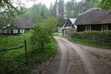 |
Liela meža masīva vidū gleznainās Būkas (Būka) upes krastos starp kokiem ieslēpies teiksmainais Vaišnoriškes ciems. Šis ir viens no skaistākajiem nacionālā parka etnogrāfiskajiem ciemiem. Vaišnoriške kā apdzīvota vieta sākusi veidoties 1756. g., kad šeit sena vēsturiska ceļa malā darbojies krogs. Pirmā viensēta ciematā ir zināma no 1830. g. Šodien redzamā apbūve ir tapusi g.k. 20. gs. sākumā. Ciems ir palicis cilvēku atmiņās ar liepu medu, jo meža velšu vākšana un biškopība bija viena no galvenajām šejieniešu nodarbēm. Tagad ciemā ir piecas sētas. No Vaišnoriškes var uzsākt laivu braucienu pa seklo un dzidro Būku. |
|
 |
From the 6th century until the 8th century instead of the current Grobina the largest known Scandinavian trade and warrior colony in the Baltic States was located. Settlers from the inlands of Gotland and Sweden established their settlement at the hillock that was then located at the bank of the navigable Alande River. It is believed that the Cours Castle – Seeburg mentioned in the chronicles of the 9th century was located exactly here. After the loss of the order castle in the 13th century Grobina became the centre of the region. The most ancient construction of the city was formed around Lielā Street, as well as around Saules and Parka Streets. |
|
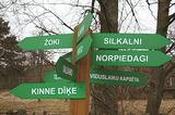 |
is seen as the newest village along the Livonian coastline. It was established during the 17th century. Košrags had 78 residents in 1826. The first reading school for Livonian children in the Dundaga seashore villages was opened at the Žoki homestead in 1832. One of the teachers was Nika Polmanis, who was the first Livonian to have completed a professional education. He also translated the Gospel of Matthew into the Eastern Livonian dialect. Košrags had a windmill, water mill and boat building facility. During the spring, job seekers from Saaremaa stopped here. A port was installed in 1932, and a breakwater to collect sea fertiliser followed in 1938. During the 1930s, Košrags was regularly visited by Finnish and Estonian linguists to study the folklore of the Livonians. The Norpiedagi homestead was built by Livonian activist Didriķis Volganskis (1884-1968). His son, Livonian cultural worker and pastor (in Finland) Edgars Vālgamā (Volganskis, 1912-2003) was born there. He translated the Andrejs Pumpurs epic "Lāčplēsis" into Finnish. Košrags today is a cultural monument of national importance. |
|
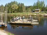 |
Ligatne history is inextricably linked to Ligatne paper mill. At the end 19th century and beginning of 20th century here was built houses, schools, maternity homes, hospitals, clubs, guest houses and other buildings for workers that have survived to the present. During the Soviet period Ligatne mill produced mainly school exercise books, which was sent to all the Soviet republics. Nowadays, the main raw material is recovered paper used for production of wrapping paper. Ligatne paper mill is the only one functioning Latvian company of this kind, and it can be explored with a local guide. Historic centre of Ligatne paper mill has been awarded the status of cultural monument. In the northern part of Ligatne - Gauja river bank the only functioning Gauja river ferry can be found and the only river ferry in the Baltic States, which is powered by river current. The ferry is vehicle of local scale. In the west of Ligatne, Ligatne nature trails are located; where close to natural environment conditions (the best object of this type in the Baltic States) lives red deer, roe deer, wild boar, fox and lynx. Within the territory of Ligatne nature trail a dense network of hiking trails and paved road - cycling route has been created, during the winter it becomes a cross-country ski track. A modern visitor centre is available here. East of Ligatne at Ligatne rehabilitation centre a unique place on the Europen scale can be found - a former Soviet secret bunker that was built as the main living and working place of Latvian senior military and civilian persons in case the nuclear or chemical weapons were used. Bunker was opened in 2003; therefore it remained intact to this day. On the way from Augsligatne to Ligatne go to see Vienkoci Park, where you can explore boats made of single wood peace by the creator of Park Richard Vidzicka, look at the different building models, sand home, and participate in themed activities. |
|
