
| No | Name | Description |
|---|---|---|
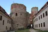 |
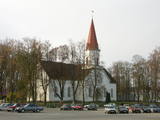
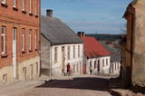
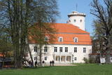
Bauska's name in historical sources for the first time is mentioned in 1443. This is the time when on the peninsula between Musa and Memel confluence construction of last Livonian Order castle on the present-day territory of Latvia was begun. At the castle – in Ķirbaksalā populated area so-called Vairogmiests developed. During the 17th century rapid boom of the town was observed. Here were working goldsmiths, silversmiths, carpenters, potters, shoemakers and other craftsmen. In later centuries the city suffered from wars, plague and Napoleon army. Today Bauska old town with reconstructed City Hall and the restored Bauska Castle is one of the most interesting Latvian historical town centres. Bauska is known for its annual events - Ancient Music Festival, Bauska town festival, country music festivals, and other events. |
|
 |
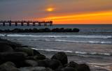
Pavilosta is a comparatively new city that has formed at the mouth of the Saka River in the Baltic Sea. True is the fact that in the medieval times the harbour of sea ships was located 6 km from the sea – at the junction of the Tebra and the Durbe Rivers. Important period in the life of the harbour was during the ruling of Duke Jacob, when sea ships arrived here. As a result of the Polish-Swedish war the Saka harbour had to be closed. The harbour that's visible nowadays in the mouth of the Saka River was formed in the middle of the 19th century at the so called Akagals fishermen village. In 1878 the river mouth was excavated and piers were built. Here two-masted ships were built. The World Wars destroyed the fleet, but the fishery traditions remained alive. In 1991 the populated area acquired the status of a city. Nowadays Pavilsota is a popular target for yachtsmen and windsurfers, as well as summer recreation place. Yachtsmen are awaited at the yacht harbour. |
|
 |
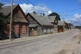
In a document from 1387, the village is named Minor Irva. Until the mid-20th century, Mazirbe was the largest Livonian village on the coast of Kurzeme. It was a fishing village and a centre for fishing. The village had a church, school, pharmacy, forestry company, several stores, a post and telegraph office, train station, barber shop, bakery and photo workshop, as well as a brick kiln. During the 1930s, a local fishing co-operative built a fish processing plant here. The Livonian Association was established here in 1923, and the Livonian People's Centre was opened in 1939. Oppoite the centre is the Stūrīši homestead (the home of the Taizel dynasty), where you can learn about everyday household objects and, by ordering it advance, taste local foods. The first chairmen of the Livonian Association, Kārlis Stalte and Māritņš Lepste, lived in Mazirbe. Cultural worker Kārlis Stalte (1870-1978) spent man years as the verger and organist of a church in Mazirbe. Mārtiņš Lepste was a Livonian language teacher in the 1930s. The former Maritime School building can be viewed from the outside. Some 2,000 students attended the school between 1894 and 1914. During Soviet years, the army had a base here. |
|
 |
Kaļķis is a populated area where
dolomite is still extracted from quarries in
the region (Kalnciems2 is one such
quarry). Some of the quarries are flooded.
|
|
 |
This is an ancient Liv village, known as Mustanumm is the last village in the south-easterly direction, and during the mid-20th century, just a few Livonians lived there. Of 307 inhabitants in 1935, only 15 were Livonians. At the beginning of the 19th century, there were six farms and a lagoon here, but at the end of the century there were 63 farms. The valley of the Baķupīte River and the sea had remnants of pilings that provided evidence about a Medieval port. Legends say that the sea robber Trommel had a castle on the left bank of the river during the 14th century. Sailing ships were once built in the region, as well. Two locations of cultural and historical importance in Melnsils are the ancient cult location that is the Baķi castle hill, and the castle hill of a sea pirate Trommel. |
|
 |
Until 13th century, Smiltene region was a part of Talava country, inhabited by Latgalians. After Crusaders invasion it was won by the Archbishop of Riga, and he built a stone castle on the steep river bank of Abuls in 1370. The following wars and epidemics did not spare the development of settlement, nor the people. Present shape of the town began to emerge in 19th century along with the vigorous activities of owner of Smiltene manor first Lieven. Until the World War I, wood working factory, hydroelectric power plant (established in 1901, first in the Baltics), and other companies were operating in Smiltene. In 1944 when the German forces retreated, much of the Smiltene historical buildings were destroyed in the fire. |
|
 |
Palanga is known to be the biggest by-the-sea resort in Lithuania because of its seacoast's main attractions - dunes and white sand. And because Palanga is a resort there are plenty of cafes, restaurants, bars and more for those who would like to enjoy a meal or a drink, for those who like active sport - there is possibility to cycle, go horseback riding, swim and much more. |
|
 |
For the first time Valmiera is mentioned in the historical sources in 1323. Until the 13th century this place was in the composition of Talava, inhabited by Latgalians. Construction of Valmiera medieval castle began in the beginning of the 13th century, but in 1283, between the Gauja River and Rate River towered church. Location near to the Tartu-Pskov and Novgorod trade routes greatly facilitated the economic development of the populated area. During the 14th-16th century Valmiera was a part of the Hanseatic League. It suffered greatly from wars, epidemics and fires in 16th to 18th century. In the second half of the 19th century the economic boom started again. It was also facilitated by the building of wooden bridge across the Gauja in 1866 and Riga-Pskov railway opened in 1899. Historic centre is destroyed in 1944. During post-war years, large industrial companies such as - Valmiera glass fiber factory (to this day) are opeating in the town. Today, Valmiera is economic, educational and sports centre of Vidzeme. |
|
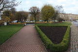 |
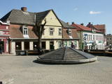
Истоки площади Роз уходят в 1911 - 1913 гг., когда на этом месте разбили открытый сад с > 500 кустами роз. В советское время рядом с площадью Роз был установлен памятник Ленину. Восстановленную в 2000 году площадь окружает Лиепайская Педагогическая академия, гостиница «Лива», Центр бизнеса и сделок De Rome (построен в XIX веке, архитектор Пауль Макс Берчи, бывшая гостиница «Рим») и Лиепайский дом латышского общества (камень в основание заложил Карлис Ульманис в 1934 г.). По бордюрам грядок роз размещены памятные знаки городов содружества Лиепаи. К площади Роз подходит улица Зивью (Рыбная), получившая свое название от когда-то существовавшего рыбного рынка. На улице Зивью находится Аллея славы латвийских музыкантов (с 2006 г.), где установлено 35 плит с бронзовым рельефом ладоней музыкантов, 10 плит, посвященные популярным латвийским музыкальным группам, а 5 – ушедшим в мир иной. Здесь же установлена самая большая гитара Латвии. |
|
 |
Kandava is first mentioned in the articles in 1230. In 1253 the Livonian Order built a stone castle at the upper part of Abava valley shore, at the foot which of an urban area formed. In the 17th century Kandava became an important trading centre. The plague epidemic and developments of World War I hit the town and its people hard. Kandava got the town rights in 1917. During soviet Soviet times, Sports Complex of Jaunkandavas agricultural Technical School became a popular training venue. |
|
 |
The largest city near the Liv Coastline, where visitors will find the Ventspils branch of the Liv Association and the Liv ensemble "Rāndalist." In nearby Tārgale are the Liv ensembles "Kāndla" and "Piški kāndla." |
|
 |
The wooden buildings with few floors emerged in the 19th century. Tourists can look at typical closed yards, verandas, wooden elements and decorations. The city suffered from fires in 1866 and 1938. The Market Square is the historical centre of Ludza, while the Ludza castle hill dominates the region. The streets of the city were established around the hill, which had an ancient Lettigalian wooden castle late in the 14th century. The Livonian Order replaced with the mightiest brick castle in Latgale. It was sacked in 1654 by the forces of Tsar Alexei Mikhailovich. The castle hill offers a lovely view of Latgale and the oldest city in Latvia and its historical centre. |
|
 |
Dundaga baron once was one of the largest landowners of Courland, therefore during the second half of 19th century around the estate formed centre of economic and social life. Dundaga Central Square is dominated by its water tower, behind which starts Dakterleja, where from 1844 to 1854 worked one of the first ethnic Latvian doctors and linguist, J. Bars. Until the sixties of the 20th century from the Dundaga through Mazirbe and fishermen villages to Ventspils ran a Narrow gauge train. Today Dundaga attracts tourists with its spectacular castle, the Lutheran church, crocodile sculpture, Eizenberga pottery workshops and other objects. |
|
|
|
One of the oldest towns in Latvia, about which data can be found already beginning from 1378. As a populated area it formed at the banks of the Tebra River (the side of Riga-Prussia road), where once the fortified wooden castle Beida of the Cours Land Bandava was located. In the medieval times Aizpute was the centre of Kurzeme bishopric. After joining Kurzeme to Russia in 1795, Jews settled for living in Aizpute. Today travellers in Aizpute are most attracted by the ancient city environment that is still alive here, as well as by the historical centre of the city and the castle ruins. |
|
 |
The history of Cēsis begins at the Riekstu hill, which is 18 m high and the surrounding area. There was a wooden castle built by the Vendian tribe that stood there from the 11th to the 13th century. The hill is in the central part of the castle’s park, and it offers a fine view of the park, a pond and the ruins of the Cēsis Castle. A long staircase leads to the hill. The Cēsis Castle was built in the early 13th century as the residence of masters of the Livonian Order, and it was one of the most fortified forts in the Baltic region. Alongside is the New Cēsis Castle, which was built in 1777 in a place where gate fortifications had been before. The building houses the Cēsis Museum of History and Art, and an annex contains the Castle Visitor Centre and the Cēsis Tourism Information Centre. From the tower of the castle, we get a good view of the castle ruins, St John’s Lutheran Church and the northern stretches of the city. Opposite the new castle is the stable of the Cēsis Castle Estate and a wheelhouse (both from the first half of the 19th century). Today these house the Cēsis Exhibition Hall. Other buildings include a granary, a hut for coachmen and an old brewery. On the other side of the street is the romantic May park, which was installed during the 1830s. Streets in Cēsis include Lielā Katrīna, Mazā Katrīna, Mazā Kalēju, Kalēju and Lielā Līvu streets and Līvu square with wooden buildings from the late 18th and early 19th century. Torņa Street stretches along the walls of the Medieval castle. Outside the church is a sculpture, “As the Centuries Pass By,” and legend has it that anyone who rubs the lantern of the Old Time Man can see the future. One of the most impressive buildings in Cēsis is St John’s Lutheran Church, which was built in the late 13th century by the Livonian Order. The Roman-style three-segment basilica has elements of Gothic design and a 65 m steeple that was installed in 1853. The building was reconstructed several times during the 20th century and contains grave plaques relates to masters of the Livonian Order and local bishops. The pulpit dates back to 1748, the oak altar was manufactured in 1858, and the altar painting “Crucified One” was painted in 1862. The windows of the altar part of the church contain artistically valuable stained glass. The organ was manufactured in 1907 by the E.F. Walker firm, and it is one of the best concert organs in Latvia. The solar clock with the number 1744 is in the south-wester corner of the church. It is worth scaling the viewing tower of the church. At its foot is Rose Square, which was a market square from the mid-13th century until 1927 and was restored in 2008. This is the central square in the city. During the Middle Ages, a punishment pole and the city well were here. Rīgas Street has been the main street in the old part of the city from the very start, and here we find most of the architecturally distinguished buildings from the 18th and 19th century – the former city hall, the Fābers house and the Princess house. At one end of the street is Liv Square, where there a church, cemetery and the Rīga gate in the city’s walls existed in the 13th century. Today the square is decorated by a lighted fountain at a place where a well was found in the 13th century. On the other end of the street we find a reconstruction of the foundations of the Rauna gate from the 14th and 15th century, offering a good look at Medieval walls and the size and strength of the gates. It is commonly claimed that the national flag of Latvia was born in Cēsis, but it must be emphasised that the flag that is mentioned in chronicles was designed in Cēsis in 1279 as the ideological prototype of the current Latvian flag, while the story of the first national flag actually comes from Valmiera, where it was sewn in 1916. |
|
|
|
Vom 18. Jh wurde die Stadt ein russischer Marinestützpunkt. Von 1962 bis 1994 war Paldiski ein Übungszentrum für atomare U-Boote der Sowjetischen Marine mit zwei auf dem Festland befindlichen Kernreaktoren (ung. 16.000 Beschäftigte) und eine "geschlossene Stadt". |
|
 |
Tukums in the historical sources is mentioned in 1253 agreement of the Livonian Order and the Bishop on the division of Kursa. If the town's name is translated from the Liv language, it means "a pile, mountains of sand". at the beginning of 14th century German merchants and craftsmen settlement was formed at the Livonian Order stone castle, whose flowering was facilitated by the proximity of Riga - Prussian road. Later the city was largely influenced by the construction of Riga - Tukums railway in1877. During the Soviet period the on the eastern outskirts of Tukums, the largest Soviet military airfield and military town in the Baltic States was deployed. Today Tukums is a district centre of the same name with a wide range of services offered to tourists. |
|
 |
Kretoņu (Kretuonas) ezera dienvidu krastā (ezeru gan neredz aizauguma dēļ) meklējams Kretoņu ciems. Šķiet, ka šī vieta ir „aizķērusies" pagātnē. Cauri ciemam iet viena iela, kurai abās pusēs izvietojušās 19. – 20. gs. mijā (dažas pat mazliet agrāk – 19. gs. vidū) celtās saimniecības. Te redzamas gan dzīvojamās, gan saimniecības ēkas, kuras rada etnogrāfiska brīvdabas muzeja sajūtu. Dažas no tām gan ir „padevušās" laika zobam. Lai vai kā, šis ir viens no neparastākajiem nacionālā parka etnogrāfiskajiem ciemiem, kuru pa „galveno ielu" vērts izstaigāt visā garumā. Šim, tāpat kā pārējiem etnogrāfiskajiem ciemiem ir piešķirts kultūras mantojuma objekta statuss. |
|
 |
Pirmo reizi vēstures avotos 1253. g. šī vieta ir minēta kā kuršu apdzīvota apmetne. Laikā no 1637. – 1639. g. te uzcēla pirmās 19 kapelas – t.s. „Krusta ceļa stacijas", kas atgādināja Jeruzalemes Krusta ceļu. Kopš tā laika Žemaišu Kalvarija ir pazīstama kā nozīmīgs svētceļnieku galamērķis. Dažas no Krusta ceļa kapelām ir veidotas 17. – 18 gs., bet citas – 19. gs. Jāatceras, ka vēl pavisam nesen – Padomju laikos svētceļniekus nežēlīgi vajāja un represēja. Mūsdienās pilsētā ir izveidots 21 svētceļnieku „pieturas punkts". Te ik gadu (parasti no 2. – 12. jūlijam) notiek Žemaišu Kalvarijas katoļu draudzes svētki, kas pulcina daudz ļaužu no dažādām Eiropas valstīm. Iespaidīgā katoļu bazilika ir slavena ar Vissvētākās Jaunavas Marijas Katoļu Ģimeņu Karalienes gleznu, kas 17. gs. atvesta no Romas. Tai piedēvē brīnumdarītājas spējas. Interesants ir pilsētas ielu tīklojums, kas atgādina 9. – 13. gs. apdzīvotas vietas ielu plānojumu. Noteikti apskatāms iespaidīgais Žemaišu Kalvarijas pilskalns, kas slejas mazās Varduvas (Varduva) upītes krastā. |
|
 |
Dobele name in historical sources for the first time is mentioned in1254. Dobele was one of the most fortified Semigallian places; therefore from 1279 until 1289 it survived six attacks by German crusaders. In 1289 Semigallians was forced to retreat. In 1335 conquerors instead of Semigallian castle began construction of new - stone castle. On the opposite shore of Berze - on the left bank merchants and craftsmen village began to form. Town suffered greatly during the Northern War and during the subsequent plague. A significant event in the economic life was the 1927, when Liepaja-Gludas railway line was built. After World War II in Dobele and its vicinity came to the Soviet militaries, who built one of the largest Soviet tanks range "Dobele-2". Now Dobele travellers are offered a range of interesting sites to be visited. |
|
