
| No | Name | Description |
|---|---|---|
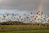 |
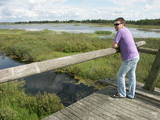
This is one of the most popular bird-watching locations in Estonia, and during spring and autumn migration there are a great many different kinds of birds resting and feeding in the meadows and shallow coastal waters of the Bay of Matsalu and the Kasari River.
|
|
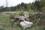 |
The former Soviet-era fuel base was part of the military facilities at that time. Fuel tanks from this site have been removed and no longer exist. |
|
 |
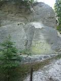
Ļoļi Devil’s Footprint is situated in Mākoņkalns rural territory in a small forest lawn several meters from the
ditch, which is a borderline of the Rēzekne and Krāslava districts. It is about 1,9 m high truncated cone, the base
perimeter 1,8 m. According to the legend, the boulder had a curvy of the horseshoe prints. Now it’s shapeless. For the
first time the stone as a geological monument was established in the 1930s. It was in Andrupene rural territory.
|
|
 |
Das alte zemgalicshe wirtschaftspolitische Zentrum, das eine stark befestigte Siedlung vor der Ankunft der Kreuzritter war. Die Ruinen der Burg des Livländischen Ordens. |
|
 |
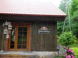
This saloon is in a lovely place – the ancient Abava River valley between Kandava and Sabile. It is housed in an historical building with among the largest chimneys in the Baltic States. A camp for water tourists is alongside the saloon. Latvian cuisine: Chilled beet soup, dumpling soup, sorrel soup, sauerkraut soup, chicken livers, homemade steak haché, dried pork ribs, roast pork, grilled pork, potato pancakes with cream, crepes, herbal teas. Special foods: Cabbage stuffed with smoked meat, cottage cheese and onions. |
|
 |
Atpūtas vieta ģimenes īpašumā Vārvē, kurā tiek piedāvāti pirts rituāli. Tāpat ir iespēja pārnakšņot namiņā un atpūsties pie dabas un Ventas upes. |
|
 4 days
|
Салаца с точки зрения водного туризма является интересной рекой, на которой даже в период маловодья будут радовать береговые ландшафты и объекты осмотра, а также многообразие самой реки. Для похода на лодках самыми привлекетельными будут окрестности Мазсалацы и участок Мерниеки – Вецсалаца, где на карте видны топонимы, связанные с заколами. Заколы (лат. tacis) – бывшие места ловли миноги – это та уникальность, характерная только для Салацы на участке реки ниже впадения реки Иге. В наши дни о прежнем существовании заколов свидетельствуют топонимы – Гедерту тацис, Жвигулю тацис и др. Заколы для миног строили в местах, где река самая мелкая, самая узкая, более богата островами и стремнинами, поэтому топоним «тацис» означает также самые интересные обстоятельства для сплава. Сами заколы сохранились только в нижнем течении реки у Салацгривы. Ночлег в основном на стоянках для водных туристов (в палатках). Маршрут проходит по территории Северовидземского биосферного заповедника. Информация о маршруте от Latvijas Lauku forums |
|
 |
The Tado Ivanausko farm and apple orchard have a memorial museum that is in Ringaudosa in the Kaunas District. The memorial farm has a house in which the museum is located, a gardener's house, a poultry coop and a garden and park that cover approximately 4 ha. The name of the location is based on very floral and fertile apple trees. |
|
 |
The Sietiņiezis cliff is on the right bank of the Gauja River between Valmiera and Jāņmuiža (follow signs along the road). There is a circular nature trail here. Sietiņiezis is one of the largest white sandstone cliffs in Latvia, up to 15 m high and around 500 metres long. There is an interesting diversity in form here, with small caves and niches, erosion-based ravines, as well as sandstone formations which are reminiscent of poles. The word "sietiņš" refers to "sieve," and the cliff is so called because bees have drilled holes into it for time eternal. From the southern part of Sietiņiezis, you can get a good look at the ancient Gauja River valley, and all around it are lovely pine forests. There is a place on the banks of the Gauja which is meant for campfires and meals. |
|
 |
The tower is at the western end of the Seda swamp, accessed from the side of Jērcēni. Transport is limited here. The tower is in the area of the swamp where peat moss is extracted. It offers a broad view of the ponds of Seda and a boat rental facility that is nearby. It is an appropriate location for bird-watching during the season of migration. There is another bird-watching platform near the town of Seda. This is part of the ZBR. |
|
 |
This farm offers education about animals who live there, how they are bred and what the origins of their breeds are. You can gather eggs, learn to sit on a saddle and ride horses. The farm has Aberdeen Angus cattle, alpacas, various birds, horses, ponies, rabbits and goats. |
|
|
|
Auf einer hohen vom Wald bedeckten Düne, wo sich in 14 – 15 Jh. ein heidnisches Heiligtum und eine Sternwarte befand, wurde 1869 eine Kapelle und Skulptur erbaut. Eine Geschichte über Priesterin Birute, die das Großfürsten Kestutis geheiratet und den Sohn Vitautas geboren hat. |
|
 2 days
|
This route offers most unusual views. Seda is the only town in Latvia with Soviet-era planning from the middle of the last century, featuring a central square and streets stretching from it in a star pattern. The architectural style of apartment and public buildings is rather exotic. The Seda Swamp yielded peat moss during the first period of Latvia’s independence and is one of the largest industrial and environmental territories of its kind in Latvia and the Baltic States. Former peat fields have partly become flooded and are overgrown with reeds, thus creating an outstanding environment for nesting water birds and migrating birds which rest at the swamp. Peat is still being extracted, and perhaps you will be lucky enough to spot the “little peat moss train.” Route information from Latvijas Lauku forums |
|
 5 days
|
Historians say that the Livs or Livonians lived in the territory of Latvia long ago, starting in the 10th century. They populated Northern Kurzeme and the river banks of the Daugava and Gauja rivers. They asked the first German tradesmen who appeared in the area about the price of textiles at the market in Visby. This means that they were familiar with the island of Gotland. The Livonians were courageous and spiritually strong seafarers, because only strong men can live with the sea, go fishing and seal trapping, and take root in the by no means fertile sands of the seashore. The territory between Ģipka and Ovīši is known as the Livonian coastline. There are still romantic seashore fishing villages of Livonian origin, as well as Cape Kolka, where the great Latvian activist Krišjānis Valdemārs insisted that it was the centre of Europe. Livonians all along the seashore responded to his call by taking part in building sailing ships all the way up to Ainaži, where there was a maritime school. That allowed the ships to sail to the far corners of the world, thus creating a century of sailing ships. This wasn’t possible without the Livonians. Also on the coastline are the oldest lighthouses in Latvia, with the one at Ovīši still serving as a star that shows the route for seaborne ships that are heading for Rīga. The Livonian heritage is also seen in the tradition of fishing for lamprey eels – something that is still very much in place in Carnikava, Svētciems and Salacgrīva. Old-time fishing equipment that cannot be seen anywhere else is on display in the latter town. The Latvian nation emerged when the Livonians flowed together with the Lettigalians, the Livonians joke. It may be that there is some truth in the anecdote. Liv or Livonian culture, lifestyles and history are closely linked to Latvia and cannot be separated from it. |
|
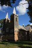 |
В1699 в центре Нюкши Пасиенские доминиканские монахи построили часовню, на месте которой в 1765 году помещик Хилзен возвел новую церковь. Помещения были маленькие, и в 1922 - 1926 гг. на фундаменте старой церкви строится новая и большая – теперешняя церковь, которую называют одним из самых красивейших деревянных храмов Латгалии. В здании находится центральный алтарь работы второй четверти XVIII века и два боковых алтаря работы примерно 1700 г. Церковь можно осмотреть изнутри. |
|
|
|
Vom 18. Jh wurde die Stadt ein russischer Marinestützpunkt. Von 1962 bis 1994 war Paldiski ein Übungszentrum für atomare U-Boote der Sowjetischen Marine mit zwei auf dem Festland befindlichen Kernreaktoren (ung. 16.000 Beschäftigte) und eine "geschlossene Stadt". |
|
 |
The farmstead grows apples, strawberries, black currants, red currants, etc., berries and fruits; there is a big selection of processed goods: natural juices, nectars and syrups. There are offered apple, strawberry, red currant, gooseberry, sea-buckthorn and chokeberry saplings; consultations are given for making out a commercial garden and taking care of it. Excursions around the commercially grown plants. |
|
 |
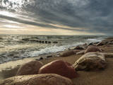
Ķurmrags is one of the most distinct capes along the Vidzeme shore of the
|
|
 |
The tavern is located in the old log building close to Liepupe Church. There is an old cattle-shed next to the tavern where we make meat and sausage products that you can purchase in the Sudrabņi meat and sausage store. We offer tours and tastings. |
|
 |
The Slītere National Park (established in 2000) is known, with good reason, as an open-air museum which shows the historical development of the Baltic Sea. Nowadays evidence of geological events is seen in the Blue Hills of Slītere, which stand 20 to 30 metres high above what was the shore of the Baltic lake of ice 10,000 years ago. The Stiebri hills were former 8,000 or 9,000 years ago, while the Littorina Sea formed Europe’s largest set of dune ramparts and damp hollows between those ramparts. This occurred between 4,000 and 7,000 years ago. The gentle climate of Northern Kurzeme is the reason why so many rare plants are found in the park – some 860 in all including Common Yew (Taxus baccata) and Baltic Ivy (Hedera helix var. baltica). Of certain value in the preservation of these treasures was the Soviet military machine, which has left behind army bases and other military objects in the area. The presence of the military meant that the area of what is now the Slītere National Park remained largely undisturbed for 50 years. The park includes one of the most popular tourist destinations in Latvia – the Cape of Kolka, which is visited by more than 50,000 travellers each year. During the spring migration of birds, more than 60,000 birds cross the cape each hour. Along the shore of the Baltic Sea is the so-called Livonian coast, which stretches from Kolka to Sīkrags and Ovīši. Fishing villages and other cultural objects established by the world’s smallest ethnic minority, the Livonians, can be found here. Tourists will enjoy interesting four nature trails, bicycling routes, viewing tower, etc. The visitors centre is located at the Slītere lighthouse. Administration of National park is organising environmental education events on regular basis open to everyone. |
|


