
| No | Name | Description |
|---|---|---|
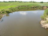 |
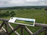
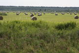
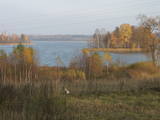
The Dviete Wetlands Nature Park contains a unique natural territory – the ancient Dviete River valley with the Lake Skuķi and the Lake Dviete and the surrounding wetland meadows. During flooding season, these wetlands store up waters from the Daugava River. They absorb a lot of floodwater at first and then slowly return it, thus reducing the level of floods in the Daugava River valley. This process is the reason for the unique ecosystem which exists in this area. It is an important location for plants and birds both during migration and nesting season. The river valley is important for birds during migration and nesting. In 2006, wild cows were released into the meadows. There is also work to improve the tourist infrastructure in the area. |
|
 |
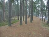
One of the highest dunes in Latvia, located between Bernāti and Jūrmalciems villages. It is 37m high and offers a magnificent view of the sea and natural pine forests. The highest dunes in Latvia stand to the South of Jūrmalciems village: the Pūsēnu hill, the Ķupu hill, the Mietragkalns or Tiesas hill, the Pāļu hill, the Garais hill, the Ātrais hill, the Lāvas hill. The Pūsēnu dune is the highest of these dunes which are all called hills by the local people. The Pūsēnu hill developed between 1785 to 1835 when shifting sand became extremely dangerous. Several homesteads were buried in sand, among them „Pūsēni”, where a forester’s family lived. The family is said to have moved to Bārta. The dune was named after the buried homestead. Jēkabs Janševskis, a Latvian writer, wrote in his book „Nīca”: “In olden times, large pine trees were growing in the dunes on the coast of Nīca and they stood steady and firm. But i Swedish times (around 1650), the Swedes built a large kiln for charcoal and tar. Pine wood and stumps provided an excellent material for this. Once a big fire rose, and the charcoal kiln burned down as well as the whole pine forest. The remaining stumps and bare trunks in the vast burnout could not hold the storm-driven sand; it flew further and further burying not only the burned-out forest, but also the nearest fields. In wintertime, when the vast, low marshy grasslands were covered with ice, jets of sand drifted further over its surface, and soon most of the grasslands and large meadows turned into sandy heath-land and dunes.” To reconstruct Liepāja, severely damaged during WWII, a silicate brick factory was built in the town. The main raw material was white sand and it was taken from the Bernātu forest. In the 1960-ies they started to dig off the Green Dune and the White Dune, later also the Pūsēnu hill. The excavators used to work day and night, in three shifts. The work stopped at around 1980, as there was no more sand suitable for production of brick. A trail is set up to facilitate walking in the Pūsēnu Dune in the Bernātu Nature Park. |
|
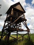 |
Atrodas Skuķu ezera dienvidrietumu krastā. Sasniedzams no Putnu salas, ejot cauri dzīvei savvaļā pielāgoto mājlopu aplokiem un taku. No torņa labi pārskatāma Dvietes paliene (ūdeņainos pavasaros pārplūst) un aizaugušais Skuķu ezers. Laba putnu vērošanas vieta. Putnu salas Atālu mājās – vietējais gids. |
|
 |
This territory is rich with forestland and lakes (some 285 in all). There are extensive opportunities for active recreation or calm leisure.
|
|
 |
This park is in a region of hillocks in the Karula highlands, and Lake Ähijärve is at its centre. The park offers a cultural environment of small farms, and it was set up to protect the unique cupola-shaped hillocks of the area. Main attractions: Scenic Lake Ähijärv (176ha), Rebasemõisa Tornimägi hill (137.8 m above sea level), undulating landscapes. |
|
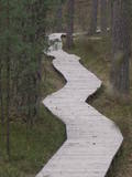 |
One of the most attractive and informative nature trails in the environs of Rīga. It leads the visitor around the 17-metre Ragakāpa dune, which is most interesting. People can learn about the habitats of the dune areas and the plants and animals of the area. Some of the pine trees are as much as 100 years old and more. The trail is 2km long in each direction and will take some two hours to traverse. This is part of the Ragakāpa nature park.
|
|
 |
This is a small area with lots of different terrains – high hillocks, distinct river valleys, thermal streams, continental dunes, etc.
|
|
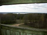 |
This is one of the highest points among the hillocks of the Selonian area of Zemgale – Borīškalns Hill. From the tower, you will see Lake Sauka, as well as the forests and farmland which surround it. The “Kalna Ļūdāni” farm is nearby, and its owner uses his livestock to help to maintain the surrounding landscape.
|
|
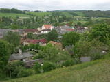 |
The Wine Hill of Sabile has been known since the age of the Duchy of Courland as the northernmost place where grapes were grown to produce more or less sour wine for the duchy. A wine festival has been held each year during the latter half of July in Sabile since 1999. The hill offers an excellent view of the small town that is on the banks of the ancient Abava River Valley. |
|
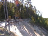 |
This nature park covers an area of the Baltic Sea coast and part of newly established sea protected area "Nida - Pērkone" with sand dunes which once used to move around but have now settled. These are the highest dunes in Latvia. Visitors will enjoy the coastal landscape, sandy beaches and small fishing villages of the area. A nature trail has been established on Pūsēni Hill (one of the highest dunes in Latvia) for those who wish to tour the nature park. |
|
 |
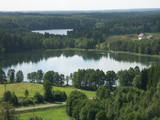
The key treasure in this park is that it has a lake that is one of the most intensive sites for birdwatchers in all of Latvia. It also features outstanding flora and the shallow waters of the Bay of Rīga. Recommended: Hike along the seashore from Mērsrags to Engure (20 km). See wild domestic animals (horses and cows) on the eastern shore of Lake Engure. There’s a bird-watching tower on the NW shore of the lake (approach from Kūļciems, where you can see domestic animals adapted to life in the wild, including the Blue Cows of Latvia). A bird-watching tower can be found at a place called Jomiņa near Mērsrags, where the seashore meadow is an uncommon biotope
|
|
 |
This is one of the most outstanding areas in the entire Baltic States with active underground waterways which still, to this very day, dissolve local gypsum rock. Parts of the area collapse regularly, and there are legends about all of this. Underwater rivers, streams, the so-called Karvės (Cow) cave, etc., can be seen in the area.
|
|
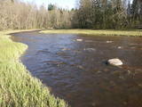 |
The nature park in the Ogre River valley is found along the middle section of the river. It has been established so as to protect the unregulated river valley and its surrounding territory, as well as biological diversity and habitats. For instance, this is an area in which rare park-type meadows can be found in Latvia. The Ogre is one of Latvia’s most popular rivers for water tourism in the spring, particularly downriver from the town of Ērgļi, where the technically complicated Braži rapids are found. |
|
 |
Open landscape area within farming lands on both banks of Uzava River about 10 km before it flows into the Baltic Sea. There is a good open view over the area from the Vendzava-Ziri road going through the nature park. Protection of migratory birds and corncrakes has been one of the main reasons for establishment of the nature park. Bird watching is possible from the road Vendzava-Ziri during migration period in spring and fall. There is no tourist infrastructure in the nature park.
|
|
 |
The terrain in this territory was created during the Ice Age. There are the ancient river valleys of the Minija, Salantas and Erla rivers, along with groups of rocks.
|
|
|
|
Meklējams pie Gulbjiem – Dvietes senlejas informācijas centra. No torņa labi pārskatāma ūdeņiem bagātos pavasaros pārplūstošā Dvietes paliene, dzīvei savvaļā pielāgoto mājlopu aploki un izlīkumotā Dvietes upīte. |
|
 |
The Dole is the largest island in the Daugava River, surrounded to the Northeast by the rapid waters of the Daugava and to the Southwest by calm and gradually overgrown waters from Dry Daugava. The island is a specially protected nature park, established in 1986 to protect the landscape and cultural and historical values of the island in the wake of the construction of the Rīga hydroelectric power plant, as well as rare and protected species of plants and animals. The island is also meant to provide education and leisure for visitors. Best known on the island is the Daugava Museum, which is in the mansion of the old Dole Estate. The museum features some 13,000 exhibits that speak to the history of the island and the river – Baltic and Livonian apparel, tools and household objects. The exhibition also presents the Daugava as an important waterway and the related history of forms of transport and rafters. In the park is an open-air exhibition with reconstructed lamprey eel traps and a barrier to fish salmon, along with a set of fishing tools. A dolomite cliff is alongside the museum on the steep shore of the Dry Daugava. The ruins of the Vecdole castle can be found on the south-eastern end of the island, near Bēči. |
|
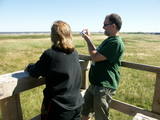 |
The viewing tower is in a seaside meadow near Mērsrags. It is an unusual type of biotope in Latvia and is located to the North of the Mērsrags port. The tower offers a good view of reed-filled meadows, areas where wild cattle have grazed, and an amazing wealth of different kinds of plants. |
|
 |
Ārkārtīgi ainaviska teritorija Augšzemes augstienes centrālajā daļā ar vairākiem ezeriem - Medumu, Lielo un Mazo Ilgas, Šķirsteņu un dažām mazākām ūdenstilpēm. Medumu ezera salām ir dabas lieguma statuss. Teritoriju šķērso vairāki grantēti ceļi, no kuriem dažviet paveras brīnišķīgas, bet nelabiekārtotas skatu vietas. Teritorijā atrodas Medumu katoļu baznīca. Piemērota teritorija dažādu aktīvā tūrisma veidu attīstībai. Dabas parks ietilpst Augšzemes aizsargājamo ainavu apvidū. |
|
 |
This territory is meant to protect the “green zone” of Rīga. Most of the park is covered with pine forest and dunes with shrubs on them, but Lake Beberbeķi is found at the southern end of the park. The area around the lake has been improved. |
|


