
| No | Name | Description |
|---|---|---|
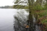 |
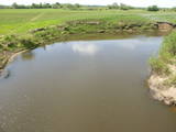
It is rare type of lake in Latvia and there are only of few this type of lakes in Kurzeme region. The lake is characterized by high water limpidness (very attractive for tourists) and very rare plant species for Latvia. Nature park includes the lake, costal area and forest on the East from the lake, few smaller lakes and Sarlote Pond. There are several tourist accommodations located around the lake.
|
|
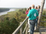 |
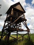
The old wooden tower at this site was torn down and replaced with the one that is there now. The restored tower offers one of the loveliest views in Eastern Latvia – one of the eight curves of the Daugava. This is the Rozališki curve. Here you will get a whole new sense of the Daugava River and its mighty valley in a place where the waters of a hydroelectric plant bubble away in our present day and age. It is claimed that the scene that is seen on the 10 lats note is based on the view which can be seen to the West from the tower. |
|
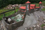 |
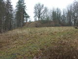
The Naujene castle hill is on the steep bank of the Daugava River, is up to 25 metres high and has two valleys on its sides. Between 1275 and 1277, the master of the Livonian Order, Ernst von Ratzenburg, organised the construction of a brick castle to replace a Lettigalian wooden castle that had stood there before. The castle had a drawbridge and an external and internal forecastle. Until the middle part of the 16th century, the castle was the residence of one of the top officials in Dünaburg. The forces of Ivan the Terrible sacked the castle in 1577, after which the location lost its strategic importance. New fortifications were built in the location that is now the city of Daugavpils. Alongside the ruins of the castle is a miniature model that helps to imagine the appearance of the location many centuries ago. A well-appointed pathway leads from the car park to the castle hill. The hill offers one of the loveliest views of the curvy Daugava River and its surrounding nature park. |
|
 |
Kauņas jūras reģionālais parks (Kauno marių regioninis parkas) dibināts 1992. gadā. Tas ietver Nemunas HES uzpludināto posmu – lielāko Lietuvas ūdenskrātuvi no Kauņas līdz Piļonas (Piliuona) ciemam. Viena no nozīmīgākajām parka vērtībām ir ainava, kas veidojusies ilgā cilvēka un dabas mijiedarbībā. Parkā konstatētas 950 augu sugas, 600 dzīvnieku, t.sk. - 34 zivju sugas. Parka nozīmīgas dabas vērtības ir meži, augstie purvi, kadiķu audze. Parkā ir apskatāmi dažādu vēsturisko periodu liecinieki – senču pilskalni, Pažaislis klosteris, Kauņas cietokšņa Piektais forts, kā arī Rumšišķes (Rumšiškės) brīvdabas muzejs – viens no lielākajiem (195 ha) šāda veida muzejiem Eiropā. Vaišvīdavā (Vaišvydava) ir izveidots parka apmeklētāju centrs, parkā ir dabas takas, piemēram, Žiegždriai ģeoloģiskā taka un Dubravos izziņas taka. |
|
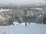 |
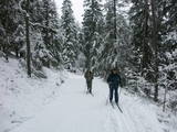
Gaiziņkalns Hill is the highest hill in Latvia, and it is a typical example of the hillocks of the Vidzeme highlands. This is a place of wonderful landscapes, even though there are not all that many good viewing areas. At the centre of this park is Gaiziņkalns Hill itself – the highest place in Latvia and the second highest in the Baltic States (311.6 metres above sea level). The viewing tower, alas is not open to the public, because it is in dangerous condition. There is a well-appointed hiking trail around Gaiziņkalns Hill, and during the winter the hill and its surroundings are popular for downhill and cross-country skiing. Lake Viešūrs (Lake Kaķītis) is popular among licensed fishermen. This territory is part of a region of protected landscapes around Vestiena. |
|
 |
The Dviete Wetlands Nature Park contains a unique natural territory – the ancient Dviete River valley with the Lake Skuķi and the Lake Dviete and the surrounding wetland meadows. During flooding season, these wetlands store up waters from the Daugava River. They absorb a lot of floodwater at first and then slowly return it, thus reducing the level of floods in the Daugava River valley. This process is the reason for the unique ecosystem which exists in this area. It is an important location for plants and birds both during migration and nesting season. The river valley is important for birds during migration and nesting. In 2006, wild cows were released into the meadows. There is also work to improve the tourist infrastructure in the area. |
|
 |
One of the most attractive and informative nature trails in the environs of Rīga. It leads the visitor around the 17-metre Ragakāpa dune, which is most interesting. People can learn about the habitats of the dune areas and the plants and animals of the area. Some of the pine trees are as much as 100 years old and more. The trail is 2km long in each direction and will take some two hours to traverse. This is part of the Ragakāpa nature park.
|
|
|
|
The viewing tower is on the western part of the Blue Hills of Ogre, not far from the Dubkalni quarry. Paths lead to the tower, as does a wooden staircase. The viewing platform offers a very broad view of the Ķegums hydroelectric power plant reservoir and the towers of
|
|
 |
The tower is on the banks of the little Tērvete River, with a view of the river valley and surrounding forests. Good views of the Tērvete River valley are also available from the nearby Zviedru Hill and the Tērvete castle hill. Note: The viewing tower at the Tērvete Ancient History Museum is not open to visitors!
|
|
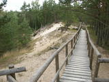 |
The trail climbs up and down along the bluffs of lower River Pilsupe and reveals a fascinating sight of three white dune exposures (the largest is called the White Dune). The trail is 900m long, and the White Dune is ca 20m high. It has formed ca 6000 years ago, in the period of the Littorina Sea which is a foregoer of the Baltic Sea. Here the first Stone Age settlement on the North Western coast of Latvia has been found in 1934 by geologist S. Burhards. In the sand, some 500m from the sea, he found some pottery fragments, a sandstone hone, a piece of flint, parts of bones and an amber bead. He handed the findings over to the National Museum of History. In October 1934, the site was checked by archaeologist E. Šturms, who found the archaeological layer, typical for such settlements, in the landslides of the Pilsupe riverbanks. In 1936 he started larger excavations to continue by 1938. Totally seven, chronologically different settlements were detected and many artefacts found, including fragments of the so called Sārnate and pit-comb pottery, as well as some pieces of corded pottery. Based on these findings, the settlement is dated back to the beginning or middle of the 3rd millenary B.C., and it has been inhabited till the beginning of the 2nd millenary B.C. Especially remarkable are three clay figures in human shape which have probably been used for some religious cult purposes. Since 1993, archaeologist Ilzes Loze has discovered several pit-comb ware culture settlements in large area around Pūrciems village. They are known in research literature as „the Ģipka settlements”. |
|
 |
Atrodas Skuķu ezera dienvidrietumu krastā. Sasniedzams no Putnu salas, ejot cauri dzīvei savvaļā pielāgoto mājlopu aplokiem un taku. No torņa labi pārskatāma Dvietes paliene (ūdeņainos pavasaros pārplūst) un aizaugušais Skuķu ezers. Laba putnu vērošanas vieta. Putnu salas Atālu mājās – vietējais gids. |
|
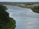 |
This lovely part of the Nemuna River between Alytus and Pakuonis meanders through cliffs that are up to 40 m high.
|
|
 |
No ģeogrāfiskā un kultūrvēsturiskā viedokļa interesanta teritorija Latgales augstienes Rāznavas paugurainē, kuras nozīmīgākie resursi ir dažāda veida biotopi, ainavas, reljefs un Šķaunes ezers. Istras pauguraines dabas parkā nav ar tūrismu saistīti labiekārtojumi, bet šo teritoriju var apskatīt arī „no malas”, braucot pa grantēto ceļu no Soboļinas uz Osinovku, kas iet līdztekus parka ziemeļu robežai (skats uz Šķaunes ezeru).
|
|
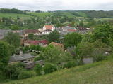 |
The Wine Hill of Sabile has been known since the age of the Duchy of Courland as the northernmost place where grapes were grown to produce more or less sour wine for the duchy. A wine festival has been held each year during the latter half of July in Sabile since 1999. The hill offers an excellent view of the small town that is on the banks of the ancient Abava River Valley. |
|
 |
The Buse (Matkule) castle hill is near the Imula River. From the castle hill and from the opposite shore of the river, you can find one of the loveliest views of Kurzeme’s small rivers. Their appearance is best when trees and other flora are bare and the view is unimpeded. A wonderful view of the Imula valley is also seen on the road to the castle hill – near the Buse homestead.
|
|
 |
The nature park near the town of Ogre is a popular place for leisure, hiking and, in the winter, cross-country skiing. Most of the park is covered with coniferous trees that are on a long and comparatively narrow line of hillocks with steep sides – another element of nature left behind in Latvia by the Ice Age. Many different plants can be found here. The Jaunogres castle hill is one of the most distinct hillocks in the area. |
|
 |
This is a small area with lots of different terrains – high hillocks, distinct river valleys, thermal streams, continental dunes, etc.
|
|
 |
From the Markova castle hill, which you will access from the local information trial, you will see a view of the Daugavsargi curve of the Daugava. Further along, you will reach the open shore of the Daugava to see one of the most unique landscapes of Latvia’s river valleys. The Slutišķi village of Old Believers and the mighty Slutišķi cliff will be in the background.
|
|
 |
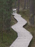
The nature trail was built in 2003 supported by the WWF, the Latvian Environment Protection Fund, the International volunteering organization supporting conservation initiatives in the United Kingdom (BTCV) involving volunteers from Nīca and Rucava municipal parishes. The trail exposes the surrounding landscapes and related biotopes – dunes, forest, grasslands and bog, as well as bird and animal species found there. On the trail, there is a bird watching tower and two birdwatcher hides. You can see the rivers Paurupe and Līgupe, beaver activity areas, grasslands, black alder forest, spruce forest, floodland, wild horses, aurochs, the Šķilu lime tree, the Holy Grove, the Ezerskolas sacrificial stone, the Pape ornithological field station, the Papes polder grasslands and the Pape lighthouse. There are resting places en route. The trail leads through the historical Ķoņu village with the traditional coastal fishing village architecture of buildings and yards. The trail is 9 km (5 km one way by a gravel road, returning 4km along the coastline). The trail is in the Pape nature park
|
|
 |
Folkloras taka "Jāņkalni" iepazīstina ar mūsu senču rakstiem, zīmēm un dievībām, kas ir mūsu folkloras mantojums. Folkloras takas (garums: apm. 1,5 km vai 2 stundas) mērķis ir arī iepazīstināšana ar senlatviešu ieražām, folkloru, kā arī tautu dainu izprašana. Piedāvā iziet Latvijas karti - labirintu ar 19 etnogrāfiskajiem novadiem. Gids Jums sniegs izsmeļošu stāstījumu un atbildes uz interesējošiem jautājumiem.
|
|


