
| No | Name | Description |
|---|---|---|
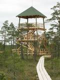 |
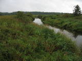
This is part of a hiking trail along the Cena bog. It is on the western side of the bog, at the centre of the 5-kilometre circular trail. You can see the vast swamp, as well as a military road that was installed during World War I and is marked by an “alley” of large pine trees. Alongside the tower is a fragment of the road that was installed more recently.
|
|
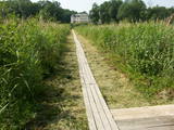 |
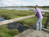
The best place to look at the restricted area of the Vīķi swamp and the Lielauce lake which is in the middle of that swamp is the Lielauce castle, where a wooden pathway stars. The pathway will lead visitors across the swampy shores of Lake Lielauce and deliver them at a boating area on the open part of the lake. The swamp itself is to the South-east of the lake. The restricted area is there to protect biotopes and species in the area. |
|
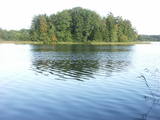 |
This restricted area protects Lake Jumurda, which is in the central part of the Vidzeme highlands, along with its three islands, the local broadleaf forests, and the surrounding landscapes.
|
|
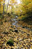 |
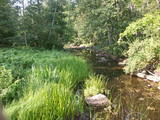
The lime gully that emerged as the Baltic ice lake receded is crossed by the powerful streams of Mežmuiža, and the water from these streams contains a high concentration of lime salts. The water from the streams flows into a mill pond that has a very interesting colour. The sculptor Teodors Zaļkalns once lived in the travertine mill that is alongside the pond. Wood pathways have been installed for those who wish to visit the streams.
|
|
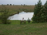 |
Along with the Nagļu ponds, these are Latvia’s largest fishing ponds. They were established on the flood-land peat areas of Lake Lubāns in the 1970s, when the hydrotechnical system of the lake was first established. The Lubāna-Gaigalava road bisects the Kvāpāni-Īdeņa ponds. There are three bird-watching towers on the dams of the ponds. The ponds are a major location for water bird nests, as well as places for migrating birds to rest. There are extensive bird-watching opportunities in the area.
|
|
 |
Zilais (Blue) Hill is the highest point in the Idumeja highlands – it is a very distinct hillock covered by forest, and from it there is a “narrow” landscape featuring the northern part of the highlands, as well as the Burtnieks flatlands. The restricted area is there to protect habitats such as gullies, hillsides and the boreal (northern) forest of the area. Zilais Hill is a popular tourist destination.
|
|
 |
The tower is at the western end of the Seda swamp, accessed from the side of Jērcēni. Transport is limited here. The tower is in the area of the swamp where peat moss is extracted. It offers a broad view of the ponds of Seda and a boat rental facility that is nearby. It is an appropriate location for bird-watching during the season of migration. There is another bird-watching platform near the town of Seda. This is part of the ZBR. |
|
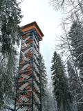 |
Dabas liegumā "Lielie Kangari" atrodas 33 metrus augsts skatu tornis, kura virsotnē atrodas platforma, no kuras paveras skats uz Kangaru ezeru un Lielkangaru purvu. Dabas liegumā izbūvēta arī nepilnu divu kilometru gara pastaigu taka ar tiltiņiem un skatu platformu pie ezera. Takas sākumā izvietotais veselības maršruts ikvienu apmeklētāju aicina kārtīgi izvingroties un izkustēties. Apmeklētāju informēšanai un izglītošanai visas takas garumā izvietoti arī informatīvie stendi ar fotogrāfijām, kas apvieno varenu stāstu un teiku kopumu par notikumiem, vietām, tēliem un parādībām dažādās apkārtnes vietās. |
|
 |
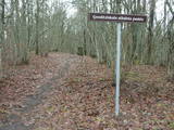
Palieņu pļavas starp Rūjienu un Rūjas ieteku Burtnieku ezerā, kurām raksturīga liela augu un putnu sugu daudzveidība. Tās robežojas ar bijušiem Rūjas zivju dīķiem, kas šobrīd aizaug ar mežu. Rūjas palienes var vērot gan braucot ar laivu pa Rūju, gan arī no ceļa, kas ved uz minētajiem dīķiem. Tur izvietots informācijas stends.
|
|
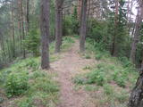 |
This is another so-called hill left behind by the Ice Age – five kilometres long with a height of between 15 and 30 metres and with high hillocks and steep hillsides. Te most distinct part of the hill can be found between Lake Pinti and Lake Šeški. The pine forests on the hillocks are a habitat with many rare and protected species. A trail has been established to tour Grebļa Hill, as well as Āža Hill and Kausu Hill, but it is recommended that visitors travel the trail in the company of a guide. The biological diversity of the area is made clear if one knows, for instance, that more than 500 kinds of butterflies have been found in the restricted territory.
|
|
 |
A distinct area of the lower reaches of the Vitrupe River, with small sandstone cliffs and many rare species of plants and molluscs. Visitors can visit the Ķirbiži Forest Museum and its information and botany trail. It weaves along both banks of the river and allows people to look at the most typical examples of flora in the region. The noble Vāloži oak tree is a key element there.
|
|
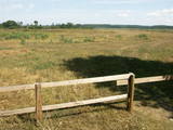 |
Periodically flooded flood-land meadows on the eastern and southern shores of Lake Burtnieks are an important nesting location for the rarely seen corncrake. A nature and information trail has been established at Vīsrags with directions, information stands and a viewing tower.
|
|


