
| No | Name | Description |
|---|---|---|
|
|
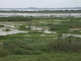
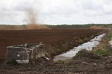
Atrodas Burtnieka ezera austrumu krastā – uz ezera poldera dambja. Pavasara un rudens migrāciju laikā – laba putnu vērošanas vieta. Putni redzami ne tikai ezera piekrastē, bet arī poldera mitrajās pļavās. |
|
 |
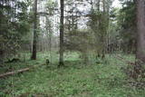
The Lake Lubāns depressions which are alongside the lake’s western and south-western parts feature little-changed forests and swamps, where many rare and protected birds nest. Many uncommon and protected habitats are in the region.
|
|
 |
Territory established mainly for protection of bog myrtle and various bird species. An interesting fact is that bog myrtle or sweet gale is used as ingredient for making famous Riga Black Balsam. Brienamais purvs (wade bog) is hard to find and reach therefore it is not suitable for tourism.
|
|
 |
There is no need to enter the bog to see it, there are good views from the highway Ventspils – Riga (77 km, bus stop “Pagrieziens uz Elkskeni”). The main value of restricted area is chalky fen bog with brown bog-rush (greatest habitat finding in Latvia). Be careful when stopping on the highway – mind the traffic! A couple of kilometers towards Riga, on the right side of the highway, there is sign to Grizu Velna kresls ( Grizu Devil Chair) which is an attractive boulder (protected).
|
|
 |
This restricted area protects the highest hillock in the Alūksne highlands – Dēliņkalns Hill – as well as the biotopes on its hillsides. The local landscape is also protected. Downhill ski trails are on the mountain, and its southern side offers lovely views.
|
|
 |
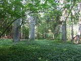
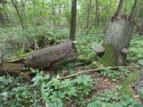
One of the rare places (see also Rucavas ivju audze) in Latvia where two rare and protected wild tree species grow - yew-tree and Baltic ivy. Territory is not marked on site with information signs or stands. Territory is not suitable for visitors as visitor without environmental knowledge will see “regular” forest. On the East side of the restricted area is located extending low wall – former narrow gauge railway (600 mm, length 41 km) line Dulbeni – Rucava. Railway was built by German military forces with the goal – to export wood.
|
|
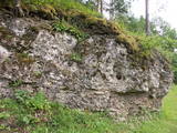 |
This is a segment of the Gauja River which is full of rapids in some places. It stretches from Vidaga and the place where the Vecpalsa River flows into the Gauja. Along the Gauja and its tributaries, dolomite outcrops can be seen on the shores, and the largest of these are the Randati cliffs. The restricted area was established mostly to protect various kinds of forests, meadows, outcrops and their habitats. This is an interesting part of the central section of the Gauja for people who enjoy beautiful landscapes and for those who are water tourists.
|
|
 |
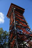
The tower is locatede in the Niedrāji-Pilka swamp. Access it via the old Ainaži-Valmiera-Smiltene narrow gauge rail line, which dates back to 1912, and then take the wooden footpaths which are approximately one kilometre long. This is a high-type swamp with small lakes at the foot of the tower. It is in the ZBR. |
|
 |
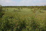
The Ukri forest on the border of the Dobele district is what is known as a vast forest. It has oak trees (including many huge ones), linden trees, oak trees (large stands of oak are uncommon in Latvia), and other deciduous trees. A small area of the forest can be toured in the company of a guide to look at the animals of the area and their importance in the flow of nature. The restricted area protects forest habitats, plants and animals, including many that are typical of the southern areas of Latvia. |
|
 |
Dabas liegums veidots ainaviskā Kāla ezera trīs salu (Tolkas, Lielā Vestienas un Vistu sala) un to mežu biotopu aizsardzībai. Diemžēl, salu apmeklētāji (makšķernieki?) aiz sevis ir atstājuši ne tikai nelabiekārtotas apmetņu un ugunskuru vietas, bet arī atkritumus. Tā kā salu vērtību spēs novērtēt tikai zinošs speciālists, ieteicams dabas liegumu vērot no skaistajiem un pauguriem klātajiem Kāla ezera ziemeļu un austrumu krastiem. Teritorija atrodas Vestienas aizsargājamo ainavu apvidū.
|
|
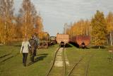 |
Sedas purva kājnieku maršruts atrodas dabas liegumā Sedas purvs, pārgājienu pa maršrutu iespējams apvienot ar Sedas pilsētas apskati, kas ir unikāls 20.gs. 50.–60. gadu pilsētbūvniecības un arhitektūras paraugs - kūdras purva strādnieku pilsēta. Maršrutam ir divi apļi - Jērcēnu aplis - 5,5 km un Sedas aplis - 4,2 km. Tajos apakatāms izstrādātais kūdras purvs, šaursliežu dzelzceļš, ritošais sastāvs, divi skatu toņi. Rudenī un pavasarī - putnu migrācijas lāikā - interesanta vieta putnu vērošanai. GPS koordinātes: Jērcēnu puses aplim: 57.7055987, 25.7001324; Sedas puses aplim: 57.6699587, 25.7514815. |
|
 |
This is Latvia’s largest lake island and is found in the middle of Lake Usma. The island is restricted to protect old stands of pine, as well as various plants and birds. |
|
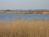 |
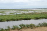
A shallow, eutrophic (more than 60% coverage), lagoon-type lake, which is a restricted area to protect the overgrowing lake and the damp meadows which surround it. There are some 60 species of nesting birds in the area. The system of dams on the southern shore of the lake can be used by visitors to look at the area.
|
|
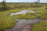 |
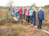
Very wide territory for a nature restricted area where extensive forests and several bogs can be found. The territory is important living space for many bird species. Vasenieku bog path with observation tower is the most attractive sites of the restricted area and offers unique landscape of the bog for its visitors. Waterproof shoes are recommended for visitors as the first 500 m of the path is molded turf rampart. Information stands are significant source of information along the path. It is suggested to visit also Stikli (Glass) village where glass factory used to be. Chandelier of Stende church has been made in this factory (by memory of Inese Roze).
|
|
 |
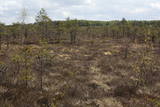
Nature restricted area is established to protect various wetland habitats – Big Kirba Bog and protected plant species within it. Only the West part of the Bog is a protected nature area. The rest of the bog is used mainly for intensive extraction of peat and large cranberry cultivation. Nature restricted area of the bog has no tourism infrastructure therefore is not useable for tourist visits.
|
|
 |
This structure is smaller than the Great Kangari hills – approximately 10 kilometres long and 16 metres high. This structure is near the Buļļi swamp, and the restricted area is meant to protect the structure, the swamp and the various forest types and rare plants that are in the area.
|
|
 |
Dabas liegums atrodas dienvidaustrumos no Lubāna ezera un tas veidots purva un meža biotopu un tajos esošo sugu aizsardzībai. Gar teritorijas ziemeļu robežu iet Nagļu - Degumnieku ceļš (iekļaujas kopējā Lubāna dambju sistēmā), pa kuru apkārt Lubāna ezeram izveidots velomaršruts. Tas nozīmē, ka teritoriju var aplūkot arī "no malas", netraucējot tās dabiskās norises. Teritorija ietilpst arī Lubāna mitrāja kompleksā.
|
|
 |
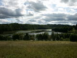
Lake Liepāja is shallow and eutrophic (around 40%), and it is one of the most important lakes on the shores of the Baltic Sea for nesting and migrating birds (resting and feeding place). More than 100 different species of birds have been spotted there. The lake is no less important for plants which flourish in salty biotopes. On the north-eastern shore of Lake Liepāja (Vītiņu meadow) there are flood-land plains which are the home to domestic animals which have been adapted to life in the wild. There is also a viewing tower, available upon request with the guide. The system of dams along the south-western part of the lake can be hiked or biked (extreme!) to find lots of interesting viewing areas and landscapes. In the surrounding of the lake there are ruins of unique former fortification systems. |
|
 |
Labi redzams no Kornetu centra. Līdz tornim var nokļūt pa taku, kas ved pāri pļavai uz uzlokas pa stāvā Dzērves kalna nogāzi. No torņa paveras viens no skaistākajiem Vidzemes un Latvijas skatiem. Redzams Dēliņkalns, blakus esošie Dzērves un Ievas ezeri, Hānjas augstiene un Lielais Munameģis (acīgākiem vērotājiem). |
|
 |
Ilziņš jeb Vestienas dzirnavezers pazīstams ar nostāstiem par tajā "periodiski uzpeldošām kūdras salām". Saskaņā ar vietējo iedzīvotāju sniegtajām ziņām, minētā parādība gan sen jau vairs nav novērota. Tajā pat laikā ezers un tā apkārtne ir nozīmīga daudzu aizsargājamu biotopu un sugu dzīves vieta. Ezers ietilpst Vestienas aizsargājamo ainavu apvidū. Ezeru var redzēt, braucot pa Ērgļu - Gaiziņkalna ceļu. Var pakāpties arī blakus esošajā paugurā (ziemeļos no minētā ceļa un ezera), no kura paveras plašāka skatu perspektīva.
|
|


