
| No | Name | Description |
|---|---|---|
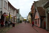 |
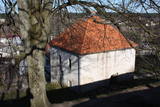
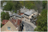
Most popular Estonian resort with wide range of leisures and SPA offers. One of the rare Estonian sandy beaches. The Old Town has the main walker street - Rüütli tee. |
|
 |
Apdzīvota vieta ~ 1 km dienvidos no Daugavpils – Krāslavas (A 6) ceļa, kas pazīstama ar savu neparasto nosaukumu. Interesanti, ka vietvārds saistīts arī ar iedzīvotāju uzvārdiem, ko var redzēt tāda paša nosaukuma kapos. Ciema apkaimē pazīstams ir Lielo Muļķu svētavots, kuru gan nezinātājam ir grūti atrast, tādēļ ieteicams izmantot vietējā gida pakalpojumus, apvienojot šīs vietas izziņu ar biškopības saimniecības „Cīruļi” apskati. |
|
 |
Ģipka is a village that once was the site of the first maritime school in Kurzeme. It was opened in 1869, just a few years after a similar school in Ainaži. This was a Category 2 maritime school, which trained helmsmen for long-distance trips and captains for short-distance trips. The school was moved to Mazirbe in 1894. Before the maritime school, the building housed a different kind of school, and a second floor was added in 1867 specifically for the maritime school. Today this is a residential building. During 28 years, the school trained more than 200 professional sailors, and it was of great importance in facilitating ship building in shoreline Liv villages. (Source: Roja TIC) |
|
 |
To the south of Koknese, the Destiny Garden is on an island that is surrounded by the waters of the Pļaviņas hydroelectric power plant (there is a bridge to the shore). The aim of this fundamental open-air object was to commemorate people in Latvia who suffered because of totalitarian regimes. The first work here began in 2008, and the designer of the landscape was a Japanese landscape architect, Shunmyo Masuno. Work on the garden continues, but it is already a popular tourist destination. The first permanent structure is a terrace that offers a view of the Koknese castle ruins and the local Lutheran church. This means that there will be something new each time that people visit the park. People are invited to bring rocks for this nationally important location that commemorates Latvia’s history. |
|
 |
This is a unique small town in a certain sense, and it is the only one in the Baltic States which has remained in place since the 17th and 18th century. The town is around the small Alekšupīte River, and in some places the stream runs along the walls of the buildings. Because of this fact and the many bridges that are in town, Kuldīga has become known as “the Venice of Latvia.” Baznīcas, Liepājas, Kalna and other streets are full of interesting cultural monuments. |
|
 |
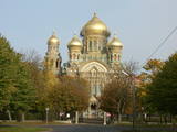
Истоки площади Роз уходят в 1911 - 1913 гг., когда на этом месте разбили открытый сад с > 500 кустами роз. В советское время рядом с площадью Роз был установлен памятник Ленину. Восстановленную в 2000 году площадь окружает Лиепайская Педагогическая академия, гостиница «Лива», Центр бизнеса и сделок De Rome (построен в XIX веке, архитектор Пауль Макс Берчи, бывшая гостиница «Рим») и Лиепайский дом латышского общества (камень в основание заложил Карлис Ульманис в 1934 г.). По бордюрам грядок роз размещены памятные знаки городов содружества Лиепаи. К площади Роз подходит улица Зивью (Рыбная), получившая свое название от когда-то существовавшего рыбного рынка. На улице Зивью находится Аллея славы латвийских музыкантов (с 2006 г.), где установлено 35 плит с бронзовым рельефом ладоней музыкантов, 10 плит, посвященные популярным латвийским музыкальным группам, а 5 – ушедшим в мир иной. Здесь же установлена самая большая гитара Латвии. |
|
 |
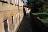
The wooden buildings with few floors emerged in the 19th century. Tourists can look at typical closed yards, verandas, wooden elements and decorations. The city suffered from fires in 1866 and 1938. The Market Square is the historical centre of Ludza, while the Ludza castle hill dominates the region. The streets of the city were established around the hill, which had an ancient Lettigalian wooden castle late in the 14th century. The Livonian Order replaced with the mightiest brick castle in Latgale. It was sacked in 1654 by the forces of Tsar Alexei Mikhailovich. The castle hill offers a lovely view of Latgale and the oldest city in Latvia and its historical centre. |
|
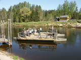 |
Ligatne history is inextricably linked to Ligatne paper mill. At the end 19th century and beginning of 20th century here was built houses, schools, maternity homes, hospitals, clubs, guest houses and other buildings for workers that have survived to the present. During the Soviet period Ligatne mill produced mainly school exercise books, which was sent to all the Soviet republics. Nowadays, the main raw material is recovered paper used for production of wrapping paper. Ligatne paper mill is the only one functioning Latvian company of this kind, and it can be explored with a local guide. Historic centre of Ligatne paper mill has been awarded the status of cultural monument. In the northern part of Ligatne - Gauja river bank the only functioning Gauja river ferry can be found and the only river ferry in the Baltic States, which is powered by river current. The ferry is vehicle of local scale. In the west of Ligatne, Ligatne nature trails are located; where close to natural environment conditions (the best object of this type in the Baltic States) lives red deer, roe deer, wild boar, fox and lynx. Within the territory of Ligatne nature trail a dense network of hiking trails and paved road - cycling route has been created, during the winter it becomes a cross-country ski track. A modern visitor centre is available here. East of Ligatne at Ligatne rehabilitation centre a unique place on the Europen scale can be found - a former Soviet secret bunker that was built as the main living and working place of Latvian senior military and civilian persons in case the nuclear or chemical weapons were used. Bunker was opened in 2003; therefore it remained intact to this day. On the way from Augsligatne to Ligatne go to see Vienkoci Park, where you can explore boats made of single wood peace by the creator of Park Richard Vidzicka, look at the different building models, sand home, and participate in themed activities. |
|
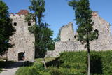 |
Exploring of Sigulda can be started with a visit to Sigulda castle ruins. The construction of the castle was begun by the Knights of the Sword Order in 1207, but in 1236 it was rebuilt for the needs of the Livonian Order. Sigulda castle suffered much from the wars in the second half of the 16th century and in the beginning of 17th century. During the Northern War, it is burned down and is no more restored. Today south-western building of the convent and the tower of the main gate, behind which is the inner forefront of the castle with open air stage, which offers impressive views over the Gauja valley. Currently the reconstruction of castle ruins is in progress. Construction of New castle (owner - Prince Kropotkin) in the South of the Sigulda took place from the 1878 until 1881. From 1923 - 1940 the building was the Palace of Writers, but during the Soviet years - Cardiology sanatorium. Since 2003 Sigulda district council is located there. The manor complex includes wooden house (middle of 19th century), which was Kropotkin's family home, barn (turn of the 18th - 19th century), gardener's house (19th century) and a stone fencing (19th century.) If we make our way from New Castle in a north-eastern direction, after almost 2 km we will reach Vejupite ravine. There you can see the shallow (3.6 m) but high (6.1 m) in Peter's Cave and deep Pucu ravine with Krauklupite. At the conjunction of ravines of both streams rises a Satezele hill fort (plateau 90 x 75 m), where in the beginning of 13th century was the oak castle of Liv land chief (eldest) - Dabrelis. Near can be found Krauklu gorge - ravine of Vejupite left bank, with 11 m high sandstone walls and 5.2 m deep Krauklu cave. At the conjunction of Vejupite ravine and Gauja valley columns Paradise (Gleznotaju) Hill - a very picturesque place, painted and photographed since old times! The Paradise Hill can be reached with a electric vehicle. In the west part of Sigulda is located Ferris wheel (works during the summer) and Air cableway (streetcar) - the only this type of vehicle in Baltics (built in the 1969). Its self-supporting cable extends in 1060 m length and without any support joins the Gauja River valley banks between Sigulda and Krimulda ~ 40 m above Gauja River. Here you can enjoy excellent views! In the south-western part of Sigulda one can walk to mighty Beites precipice, which is split by the deep ravine of stream. On the west side of the ravine lies Keizarskats, which is located ~ 67 m above the Gauja level and offers good views of Krimulda and Turaida castle. Sight place was arranged here already in the 1862 when Russian Tsar Alexander II visited Sigulda. In the eastern part of the ravine wooden Keizarkrēsls (Emperor Stool) is located. |
|
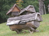 |
Das bekannteste Museum der Geschichte der Bienenzucht Litauens mit den Bienenhäusern verschidener Arte, der Arbeitsmittel der Bienenzüchter, Holzskulpturen und Hönigankauf. |
|
 |
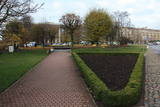
Krustpils was first recorded in documents in 1237 in relation to the construction of the Kreutzburg castle on the right bank of the Daugava River. A 1511 document lists it as a village. In 1585, Polish King Stefan Báthory gifted the town to Nicholas Korff, whose family continued to own it until 1920. Battles between Swedish and Polish forces occurred outside of Krustpils in 1626, and the sacked village was in poor shape until the mid-19th century. Jēkabpils, in turn, was constructed as a settlement for Old Believers who were persecuted in Russia. The Daugava has rapids opposite Krustpils and Jēkabpils, which means that boats had to dock there and reload their goods into wagons. The settlement flourished, and in 1670 it was given the rights of a city. It is named after Duke Jacob. When the Rīga-Daugavpils rail line opened in 1861, Krustpils flourished, and Jēkabpils did not flourish. The two cities were administratively merged in 1962, keeping the name of Jēkabpils. There are typical one-story wooden buildings from the 19th century, red brick buildings built at the turn of the 20th century, as well as seven churches used by different denominations. The dam along the left bank of the Daugava was built in 1861, and it was aimed at protecting the city against flooding. Today it is a promenade that is popular among local residents for strolling and leisure. |
|
 |
In the 15th century, Preili manor became the property of Count Borhs family. Borhs were living here until the 60ties of 19th century. The city itself formed in the first half of the 19th century by fusion of Preili Manor, the village and free village - settlement of traders and craftsman. In the 19th century a luxurious palace was built in Preili and Landscape Park was created. Today Preili is an important economic centre of Latgale (cheese and sewing plants), where t folklore, crafts and Catholicism traditions are fostered. Preili tour in the guidance of TIC employee Irena Kjarkuza is highly recommended. |
|
 |
The Old Town of Kandava is located around the old Market Square and dates back to 1881, after a fire in the town. The urban environment in Kandava is made up of farms with various buildings, closed yards, passageways and walls made of fieldstones. These can be seen in Talsu Street and Sabiles Street. Uncommon for Latvia is Lielā Street. At the foot of the Bruņinieku Castle Hill is a model of the Castle of the Livonian Order that was created in 2010. |
|
 |
The city of wind, amber and musicians. In the literature sources Liepaja was mentioned for the first time in 1253. The city strived as a trade harbour already at the end of the 16th century. Especially important was the ruling period of Kurzeme Dukes Jacob and Friedrich, when the export and import of Lithuania and Kurzeme goods was provided through Liepaja harbour. Instead of the Līva River that was filled with dune sand a channel was excavated and wharf was formed. The growth of the city continued in the 18th century also after the Northern War and the plague epidemic. When in 1795 Kurzeme was added to the Russian Empire, as one of the most important western harbours of the Empire the harbour of Liepaja developed even more rapidly. From the end of the 18th century until the 19th century Liepaja also became a popular recreation place for the aristocrats of Petersburg. At the end of the 19th century the construction works of War Port and fortress begun. The city became a military strategic place. It suffered hard during World War II. In 1967 the sea trade harbour terminated its operation in Liepaja and Liepaja became a closed city where the War Port was "a city within a city". Today the War Port and its offer is one of the top tourism spots in Latvia. |
|
 |
Smarde is an ancient place, mentioned in the 13th century documents. Today it is a small village with railway station and shops. Northeast of Smārde - former peat extraction places are located in Smārde marsh. During World War I the front line was near Smārde, the vicinity of which is witnessed by the memorial sites. |
|
|
|
Evidence found at Dievukalns tells that Baltic tribes lived at this place 3,000 years ago the, but in 7th and 9th here at the Daugava Livs tribes settled. Bishop of Riga built stone castle at the bank of the river Daugava (first mentioned in the 1229), whose ruins you can see today as well. Lielvarde is an inspiration for such people of cultural awakening time as Andrejs Pumpurs (1841-1902) and Auseklis (1850-1879). During World War I (almost three years Daugava served as front line) Lielvarde was completely destroyed. After the World War II, here, as well as elsewhere in the Latvian territory, begins the establishment of collective farms. During this time Lielvarde became known for another symbol - "Lacplesa" beer. Today Lielvarde is a favourite of travellers, who have chosen to make their route along the right bank of the Daugava. |
|
 |
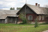
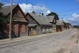
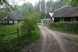
Kretoņu (Kretuonas) ezera dienvidu krastā (ezeru gan neredz aizauguma dēļ) meklējams Kretoņu ciems. Šķiet, ka šī vieta ir „aizķērusies" pagātnē. Cauri ciemam iet viena iela, kurai abās pusēs izvietojušās 19. – 20. gs. mijā (dažas pat mazliet agrāk – 19. gs. vidū) celtās saimniecības. Te redzamas gan dzīvojamās, gan saimniecības ēkas, kuras rada etnogrāfiska brīvdabas muzeja sajūtu. Dažas no tām gan ir „padevušās" laika zobam. Lai vai kā, šis ir viens no neparastākajiem nacionālā parka etnogrāfiskajiem ciemiem, kuru pa „galveno ielu" vērts izstaigāt visā garumā. Šim, tāpat kā pārējiem etnogrāfiskajiem ciemiem ir piešķirts kultūras mantojuma objekta statuss. |
|
 |
Liela meža masīva vidū gleznainās Būkas (Būka) upes krastos starp kokiem ieslēpies teiksmainais Vaišnoriškes ciems. Šis ir viens no skaistākajiem nacionālā parka etnogrāfiskajiem ciemiem. Vaišnoriške kā apdzīvota vieta sākusi veidoties 1756. g., kad šeit sena vēsturiska ceļa malā darbojies krogs. Pirmā viensēta ciematā ir zināma no 1830. g. Šodien redzamā apbūve ir tapusi g.k. 20. gs. sākumā. Ciems ir palicis cilvēku atmiņās ar liepu medu, jo meža velšu vākšana un biškopība bija viena no galvenajām šejieniešu nodarbēm. Tagad ciemā ir piecas sētas. No Vaišnoriškes var uzsākt laivu braucienu pa seklo un dzidro Būku. |
|
 |
Valdemārpils is a small and quiet town along the shore of Lake Sasmaka. A village of craftsmen and merchants was established on the land of the Sasmaka Estate in the 17th century. There were quite a few Jewish merchants and craftsmen in towns in Kurzeme during the mid-19th century, and Sasmaka was known as their capital city. The city was named Valdemārpils in 1926. Its historical 19th century centre is a monument to urban construction. The town has a Lutheran church, an Orthodox church, a former synagogue, a monument to Krišjānis Valdemārs, and an outstanding linden tree. |
|
 |
Pirmo reizi vēstures avotos 1253. g. šī vieta ir minēta kā kuršu apdzīvota apmetne. Laikā no 1637. – 1639. g. te uzcēla pirmās 19 kapelas – t.s. „Krusta ceļa stacijas", kas atgādināja Jeruzalemes Krusta ceļu. Kopš tā laika Žemaišu Kalvarija ir pazīstama kā nozīmīgs svētceļnieku galamērķis. Dažas no Krusta ceļa kapelām ir veidotas 17. – 18 gs., bet citas – 19. gs. Jāatceras, ka vēl pavisam nesen – Padomju laikos svētceļniekus nežēlīgi vajāja un represēja. Mūsdienās pilsētā ir izveidots 21 svētceļnieku „pieturas punkts". Te ik gadu (parasti no 2. – 12. jūlijam) notiek Žemaišu Kalvarijas katoļu draudzes svētki, kas pulcina daudz ļaužu no dažādām Eiropas valstīm. Iespaidīgā katoļu bazilika ir slavena ar Vissvētākās Jaunavas Marijas Katoļu Ģimeņu Karalienes gleznu, kas 17. gs. atvesta no Romas. Tai piedēvē brīnumdarītājas spējas. Interesants ir pilsētas ielu tīklojums, kas atgādina 9. – 13. gs. apdzīvotas vietas ielu plānojumu. Noteikti apskatāms iespaidīgais Žemaišu Kalvarijas pilskalns, kas slejas mazās Varduvas (Varduva) upītes krastā. |
|
