
| No | Name | Description |
|---|---|---|
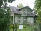 |
The Miervaldis Ķemers Museum (Durbes
street 21) is dedicated to a well known cultural
worker in Latvia (19021980) who was also a
clergyman and a painter.
|
|
 3 days
|
Это один из 6 маршрутов путешествий в серии «Насладитесь деревней!», который приглашает Примерное время прохождения маршрута: четыре – пять дней, в зависимости от количества выбранных достопримечательностей и времени, отведенного для их осмотра. |
|
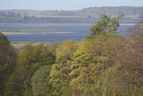 |
Nature restricted area includes eastern side of the lake with Lanupe River and North-east and South-east coastal areas. Restricted area has been established for protection of birds and floodplain meadows of the lake. To see the nature restricted area visitors do not have to enter it. There are great view points with wind generators of Grobina on the background from the road Vecpils – Rava – Aistere. Coastal areas which are not included in the restricted area are perfectly suitable for bird watching. There is located the smallest city by its population in Latvia to the South from the lake.
|
|
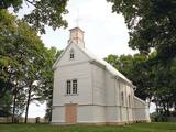 |
Roman Catolic Church of Puša was built in 1743. Financed by Count Šadurskis; managed by Jesuits
mission. There is on organ and 3 altars in the church.
|
|
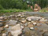 |
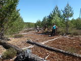
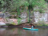
The Amata is one of Latvia's swiftest river, and water tourists congregate there each spring to engage in extreme activities. From the Rīga-Veclaicene highway, the Amata flows into a deep valley, with an average drop of more than 3 m/km or, downriver, as much as 8-10 m/km. Water tourists usually use the segment of the river between Melturi and the Zvārte cliff or the Veclauči bridge that spans the Līgatne-Kārļi road. Please remember that the Amata is not a friendly river for beginners. After lengthy rainfall, the river can be navigable during other times of the year, as well. The surrounding valley is attractive because of impressive sandstone and dolomite cliffs, among which the best known are the Vizuļi cliff (which can be the site of beautiful frozen waterfalls in winter), the Ainavu cliff, the Ķaubju cliff, the Dzilna cliff, the Zvārte cliff, and the Lustūzis cliff. Between Melturi and Veclauči, there is the Amata geological trail, which is marked with orange paint on tree trunks. There are three segments to the trail – from Melturi to the Kārļi fish farm, from the fish farm to the Zvārte cliff (both segments can be extreme!), and from the Zvārte cliff to the Veclauči bridge. You can hike the trail at any time except when there is deep snow. The most impressive views will be found when the trees are bare. If you boat down the river, you will not have time to look at or photograph the cliffs, because all of your attention will be focused on the river itself and the obstacles therein. |
|
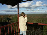 |
The viewing tower is in the southern part of the reserve, along the Ļaudona-Mārciena road and on the Madona-Trepe embankment. Here you can view a very wide territory all the way to the Vidzeme highlands, including Gaiziņkalns Hill if the weather is clear. At the foot of the tower you will see the lakes known as Small and Great Lake Plencis. |
|
 |
Teaching workshops and home cafés are common throughout Estonia, but they are found most in Peipsimaa region. During the workshops, the participants, with the help of the chef, prepare 3-4 dishes, which are then shared afterwards. Emphasis is placed on local products and the favourite recipes of Peipsimaa region. Teaching workshops are mainly organised outdoors, where a fireplace is made; a grill, pot or samovar is used. In winter, workshops even take place on the ice of Lake Peipus. |
|
 |
The Sutru Berry Garden is in the Sutru Parish in the Līvāni Administrative District. It grows blackberries in tunnels, which means that the berries ripen far more quickly than elsewhere in Latvia. You can purchase berries on site. |
|
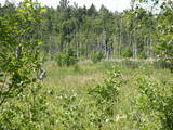 |
This swampy territory used to be part of a Littorena Sea lagoon, and it is a place where many rare and protected birds such as woodpeckers live and nest. Territory is hard to reach although some of the territory can be surveyed from the Tukums-Kolka road. Wet meadows is called "lankas" in Kurzeme region. |
|
 |
The Northern Forts of Liepāja are on the edge of the Baltic Sea, and some parts of them have been washed away. This is a small, but very impressive part of the Liepāja fortifications which once encircled the entire town. The underground bunkers of the forts are on two levels, and it’s worth visiting them in the company of a knowledgeable guide from Karosta (tours are organised from the Karosta prison). There’s a car park alongside the forts. It’s also worth walking down the beach for a distance of around four kilometres to the Northern breakwater. On the shore and in the sea, you’ll see two coastal defence batteries and some pretty impressive views.
|
|
 |
In Otepää wurde am 4. Juni 1884 die estnische Fahne geweiht. Im Pastorat ist ein Zimmer der estnischen Fahne eingerichtet. |
|
 |
The Bažas swamp is the largest swamp in the Slītere National Park and is
entirely off limits to visitors.
|
|
 |
Trušu audzēšanas saimniecība "Trušu muiža" savā allaž tapšanas procesā esošajā garaušu muižas kompleksā piedāvā aplūkot 15 – 20 dažādu šķirņu trušus no visas pasaules, kā arī iegūt bildi ar trusi. Lieliska iespēja ciemoties trušu "Harmonijas un miera sētā", tos samīļot, pabarot. "Trušu muiža" iegūst aizvien jaunus kaimiņus un pilnveidojas. Iespēja iegādāties "Trušu muižas" greznumlietas. Vaislas truši un mīļdzīvnieki. Vasaras sezonā (jūnijs - augusts) gaidīs ciemos no otrdienas līdz svētdienai (11:00 – 18:00). Lielākas grupas, iepriekš vienojoties, uzņem arī citā laikā. |
|
|
|
Ap 9 km garā taka (vienā virzienā) sākas Skaņākalna dabas parkā (Mazsalacā) un beidzas pie Ramatas. Tā iepazīstina ar Salacas ielejas dabas parka nozīmīgākajām vērtībām – smilšakmens atsegumiem (Skaņaiskalns, Dauģēnu klintis u.c.), alām, nozīmīgu izmēru laukakmeņiem u.c. Taka marķēta. Tajā izvietoti informācijas stendi, norādes. Jāpadomā par loģistiku – kā nokļūt sākuma punktā. |
|
 |
Atrodas ļoti skaistā vietā – Krimuldas muižas kompleksa teritorijā, vienā no muižas vēsturiskajām ēkām. Mājīgs interjers, mākslinieka J. Annmaņa apgleznotas sienas. Piedāvā turpat muižā darinātos mājas vīnus un „Muižas stipro”. Garšīgas tējas, uzkodas un siltie ēdieni. |
|
 |
The Brasla River flows through a lovely valley that is approximately 300 m wide and up to 30 m deep. It is near the Inčukalns-Valka highway. The river has among the most beautiful rapids in the country, with mighty cliffs (the Brasla cliffs) that can be seen at nearly every curve in the river (except along the lowest reaches of the river). During the winter, various unusual frozen waterfalls can be seen in some of the cliffs, including the Krauļukalns cliff and the Jāņavārti cliff. On the left bank of the Brasla, opposite the Brasla fish farm, there are the Aņīte cliffs -- a series of sandstone cliffs that are 1 km long. The cliffs are between 2 and 35 m in height, and the sandstone cliffs are separated by ravines. On the right bank of the Brasla, there are major cliffs such as the Vāršavu cliff, the Kraukļukalns cliff, the Jāņavārti cliff, the Slūnu cliff, the Virtaka cliff and the Buļi cliff. How can you best learn about them? Boat down the river from the aforementioned highway or even from Straupe, which is further upstream. An alternative is hiking down the right bank of the river, though please take into account that the terrain is fairly extreme, and you are going to have to think about what to do when you arrive at the place where the Brasla River flows into the Gauja. |
|
 |
Vainova Old-Believers Prayer House was built in 1980 replacing the previous
church that was burnt by lightening. Initially, the Prayer House was one of the
biggest churches in Latgale (for 2 000 people). The congregation of the church
exists since the 18th century.
|
|
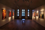 |
The Daugavpils Mark Rothko Art Centre is a multi-functional institution of culture, arts and education, located inside of the fortress' Arsenal building. It is a unique place in the Eastern Europe, where are located the original paintings of Mark Rothko – a great artist of the XX cent., a founder of the abstract expressionism movement, best known for his enigmatic color field paintings. |
|
|
|
Kartavkalnā, kur senāk atradusies seno zemgaļu apmetne, ir izveidota dabas taka ar soliņiem, piknika vietām. Šeit apskatāms arī Jaunpils Kartavu kalns un lapegļu aleja, kā arī iespējams aplūkot, kāda izskatās senlatviešu apmetne ar īstu guļbaļķu sētu.
|
|
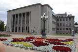 |
Found at Rīgas Street 22A, this impressive building was suggested by Latvian President Kārlis Ulmanis and built in 1936 and 1937 after a design by the architect Verners Vitands. It is seen as one of the most outstanding architectural monuments from the first period of Latvian independence, and it is said that it was once the most modern multifunctional building in all of Europe. The building now houses the Daugavpils Theatre, the Latgale Central Library, the Latvian Cultural Centre, the Latvian House, the US Information Centre, the Daugavpils Tourism Information Centre and other institutions. Unity Square is alongside the building, and beautiful compositions of flowers are nearby during the growing season. |
|


