
| No | Name | Description |
|---|---|---|
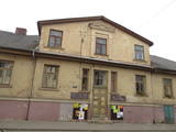 |
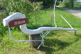
Saldus is mentioned in the historical documents already in 1253. Until the 13th century an ancient Cours castle Salden was located here, which is also represented in the coat of arms of the town. Around the 1341 Livonian Order built a castle near the Cours hill fort, where settlement formed. Its peak of development, like the other settlements of Courland, was during the reign of Duke Jacob 1642 – 1682. 1856 is mentioned as the year of the foundation of Saldus, when restoration of town perished during the Northern War begun. At the end of the World War II a big fights took place at the town, but town remained in German-occupied part of Latvian until the May 8, 1945. Modern Saldus attracts with its activities - town days, the music festival "Saldus Saule", as well as a variety of sightseeing objects, among which A/S 'Druvas Partika" can be mentioned, where you can watch how the ice cream is made and Saldus Food Factory, where you can taste the delicious candy "Gotina" and watch the production process. |
|
 |
A gourmet’s favourite in the very heart of Valmiera, opposite Valmiera Town Hall Square. Here every guest can become a gourmet and enjoy a variety of flavour "bouquets" and seasonal products that come from local farms. The restaurant's Summer Garden is designed to highlight Valmiera as a Hanseatic city of a medieval merchant association. Latvian cuisine: A selection of Latvian cheeses, Valmiera salad, potatoes in their jackets with cottage cheese, cold kefir soup, lamb soup, pike from Lake Burtnieks, baked filet of catfish, leg of lamb steak, roast pork ribs. Special foods: Rye bread baked in honey. |
|
 |
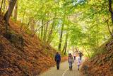
This is a territory that is unique at the Latvian and the Baltic level, one which stretches from Valmiera to the Gulbene District. Here we find the irregular Gauja River valley with a dense system of ancient rivers. The meadows on the banks of these rivers are important in terms of biological diversity. There are stands of oak and broad-leaf trees. Many rare and protected birds live and next here – the corn-crake, the woodpecker, etc. The territory is excellent for bird watching, nature studies, ecological tourism and various kinds of active tourism. |
|
 |
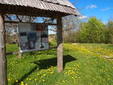
Taka izveidota Limbažu Lielezera ZA galā, tā ir 3.6 km gara vienā virzienā. Ezeru ziemeļu galā izbūvēts putnu novērošanas tornis. Izbūvēts bērnu rotaļu laukums, labiekārtotas atpūtas vietas, izveidota laivu piestātne. Pāri Donaviņai izveidots gājēju tiltiņš uz pontoniem. |
|
 |
The saloon is at the edge of the Murjāņi-Limbaži road (P9) and alongside the Igate Castle. It is built on the foundations of a former windmill, and the wheel of the mill has been preserved. The old watermill is still hard at work and is used to mill grain for traditional porridge and buns. The saloon works with local farmers. Latvian cuisine: Mushroom soup, barley porridge with meat, barley buns, grit sausage with lingonberry sauce, crepes with jam, potato pancakes, fried plaice or pike, stacked rye bread. Special foods: Sautéed rabbit, stuffed filet of turkey. |
|
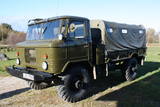 |
Edgars Kārklevalks, operator of a guesthouse Pūpoli, has a restored Soviet military GAZ-66 truck in which he offers historical and informational tours of Northern Kurzeme. The route includes former military territories.
|
|
 8 days
|
The route brings you to Kaunas, multiple Lithuanian regional parks and allows to enjoy the landscapes of the river Nemunas. Kaunas is Lithuania’s second largest city. It is notable for its modernist architecture. The city is located at the confluence of the two largest Lithuanian rivers: Nemunas and Neris. Moving further from Lampėdžiai to Vilkija, the Forest Trail runs for two days along trails and small countryside gravel roads next to the right bank of the river Nemunas. This section is shaped by beautiful landscapes with views of the river, the waterfront meadows and small villages. Do not miss the ferry in Vilkija crossing over the river Nemunas, one of the few still in operation in the Baltic States. For the next two days from Vilkija, the Forest Trail runs through its most spectacular sections in the Dubysa Regional Park from Kirkšnovė to Šiluva with mounds on riverbanks and historical churches now and there. This regional park covers the impressive Dubysa river valley, which reaches a depth of 40 m and a width of up to 500 m. Be prepared for a rolling terrain. Next, the route will take you to the town of Šiluva – the Catholic pilgrimage site – and to the Kurtuvėnai Regional Park. It is among the most forested areas of Central Lithuania; thus, the regional park with its glaciated valleys is a wonderland of forests, waters and wetlands. The Forest Trail leads along small forest paths, tourist trails, beautiful tree alleys and wetlands. The walk ends in Šaukėnai village, from where the city of Šiauliai is easily reached. |
|
 |
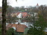
Hauptstadt von Hiiumaa. |
|
 |
Latvijas un Igaunijas Neatkarības karā nenovērtējami nozīmīgas bija tieši Cēsu kaujas 1919.gada jūnijā.Atpūtas vieta-kempings "Amatas upe" ir lieciniece tieši šo un vairāku citu kara notikumu norisei - par to liecina vēsturiskie avoti muzeju arhīvos, kā arī mūsdienās redzamās aprises dabā. Par to, kur un kā sākās varoņstāsts, kas noslēdzās ar abu kaimiņtautu: igauņu un latviešu brīvību, ir iespējams uzzināt arī dažādu veidu programmās - stāstījumā par Cēsu kauju noslēpumiem un dažādu veidu pārgājienos vai izbraucienos pa galvenajām Cēsu kauju vietām, vai arī Cēsu kauju aizraujošā "izspēlēšanā". Atpūtas daļā - apmeklētājiem ir iespēja nobaudīt spēcinošu "kara zupu". Ekskursijas pa Cēsu kauju vietām-dažāda ilguma, izstrādāsim tieši jums piemērotu variantu! |
|
 |
Neliela ziepju un dažādu citu ķermeņa kopšanas produktu darbnīca. Pašu audzētos un saimniecības pļavās ievāktos ārstniecības augus iestrādā ziepēs un skrubjos, gatavo no tiem izvilkumus augu eļļās, kurus iekļauj lūpu balzamos un krēmos. Ziepes tiek vārītas tā, kā to darīja agrāk - no sārma un taukvielām. Apmeklētājiem iespēja ielūkoties “Ezervanna” mazajā darbnīcā, paklausīties stāstā par ziepju vārīšanu, iemēģināt roku un radošumu skrubju gatavošanā vai “pamīcīties” ar ziepju veidojamo masu un pagatavot savu ziepju gabalu. |
|
 |
The town of Talsi is known as the “town of the nine hillocks,” and it is worth touring the location on foot. You’ll find the best views from the Talsi castle hill (views of Lake Talsi and Ķēniņkalns Hill), Sauleskalns (Lake Talsi, the castle hill, Ķēniņkalns Hill), and the hiking trails of Ķēniņkalns (Lake Talsi, the castle hill, the historical town centre).
|
|
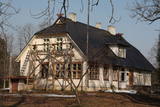 |
Several of the buildings of the Šlītere Semi-Estate have survived to the present day – the servants' house (late 19th century), the pump house (mid-19th century), the smokehouse (mid-19th century), the cattle barn, etc. A forestry building was built here in 1936 and renovated in 2010. Since the end of 2009, the administration of the Slītere National Park has been housed here. Today the building also houses the Kurzeme regional branch of the Environmental Protection Board. Opposite the building are two yews, and there is a productive ivy which has covered the northern side of the servants' house. The common yew and the Baltic ivy are symbols of Šlītere, and you can see and photograph them here without "bothering" them in their natural environment. The pump house contains a well that is unique in Latvia – it is 34 m deep, which is nearly the height of the Blue Hills of Šlītere. It reportedly was active until the 1970s and delivered water to the forestry system. A fragment of the stone well can be seen as a part of the wall of the pump house. The semi-estate is surrounded by small elements of a park, including an impressive alley of elm trees. Locals says that pre-war Latvian President Kārlis Ulmanis spent the night at the building once while on a hunt. |
|
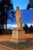 |
This 1939 monument was designed by Kārlis Zemdega and is dedicated to Agriculture Minister Arturs Alberings from the first period of Latvian independence. The monument shows a young man with a grain basket. The monument disappeared during the Soviet occupation, and a gypsum statue of a Pioneer was installed instead. In 1977, children found some parts of the old sculpture buried in the ground, and 10 years later someone found the head of the monument. After a restoration, the Sower sculpture is now in its historical location – in the Terneja Park alongside Rīgas Street. |
|
 |
To the East of the Ezermuiža-Dūmele road you will find the bed of the ancient Lake Dieviņezers. It was one of the largest lakes in Kurzeme in the past, being 7.5 km long and 1.6 km wide. A canal was dug in 1838 (Melnsilupe River today), and the water from the lake was siphoned to the sea so as to create fertile farmland. Residents of Ezermuiža have been involved in forestry work since the age when barons ruled the land. Dūmele is connected to Košrags by a lonely forest road that is known as the Bottom Road. A bike route runs down it. The Ziedkalni weekend house is in Dūmele. The "Ziedkalni" homestead in Dūmele offers spa services, cod fishing and accommodations. |
|
 |
Šis ir viens no retajiem ceļiem, kurš saglabājies kā notikumu liecinieks. Ceļš ved no Krimuldas uz Siguldu. Jau vācbaltu apgaismotāja novadpētnieka – mākslinieka Johana Kristofa Broces 1794. gada zīmējumā "Siguldas un Krimuldas pilsdrupas" redzams lauku ceļš gar Krimuldas pili, pa kuru iet zemnieks un darba ratus velk zirgs. Lai braukšana pa Gaujas senlejas nogāzi ar zirga pajūgu būtu droša, ceļu izveidoja līkloča formā, tā uzbrauktuvi padarot daudz lēzenāku. Domājams, ka ceļš atjaunots 19 gs., kad Krievijas cars Aleksandrs otrais un viņa sieva ieradušies uz vizīti siguldā. Pāri ceļam bijuši vairāki mazi tiltiņi, ko iedzīvotāji dēvējuši par velna tiltiem. Tagad serpentīna ceļš kļuvis par romantisku pastaigu vietu. |
|
 |
Camping, sauna by the sea, picnic places, rest in a romantic wooden house and accommodation in tents, canopy rental, rental of places for outdoor events. |
|
 |
Atrodas skaistā vietā – pašā Daugavas krastā. Ēdina, klāj galdus, piedāvā braucienus ar kuģīti pa Daugavu. |
|
 |
The landlady of this farm will tell you about healthy herbal teas and home-based goodies. If you wish to spend the night under the stars, we offer a place for tents and a campfire on the banks of local river by the old Lūkas windmill. “Aploki” will welcome anyone who wants to relax in a peaceful and quiet atmosphere. |
|
 |
The Centre at Sõru harbour exhibits various vessels, smaller wooden boats are built and renovated here too. The three-masted schooner Alar is awaiting restoration. Part of the Centre complex is the Sõru Museum giving an insight into local sea-going history; workshops on coastal life and seafaring can be booked in advance. |
|
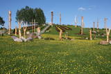 |
Atrodas nepilnus 2 km austrumos no Aglonas, Aglonas – Dagdas ceļa malā. Tā ieceres autors ir Ēriks Delpers, kurš 2006. g. uzsāka vietas labiekārtošanu, izveidojot brīvdabas skulptūru dārzu un stādījumus. Kristus Karaļa kalns šobrīd atrodas izveides procesā, taču neskatoties uz to – objekts, ko ir vērts redzēt! |
|


