
Canoeing
 |
Down the Amata river - extreme!(Latvia, 1 day)The route: 15 km Fall of the river: 70 m Distance from Rīga: The starting point at the bridge on the Vidzeme Highway that is found at Melturi - around 72 km. The finishing point at the bridge that is found on the Līgatne-Āraiši road - around 75 km. Best time to visit: Late March, April (depending on the start and intensity of spring floodwaters) Getting there: The Rīga-Cēsis-Valmiera-Lugaži train (to the "81st km" station), then about 2 km on foot to the river. By bus - the Rīga-Ērgļi route. By car - the Vidzeme Highway (A2, E77) to the Melturi bridge. |
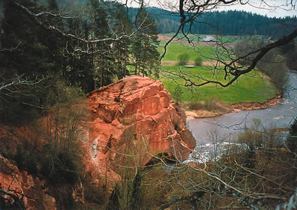
A brief description of the routeThe lower parts of the Amata river, from Melturi to the Kārļi bridge at Līgatne, flow through the territory of the Gauja National Park. The fall of the river is significant, there are rapids and steep, canyon-type banks. There are majestic sandstone cliffs from the Devonian period. There are lots of rapids, many fallen trees and major rocks. This makes the whole process of going down the river very exciting indeed. During springtime flooding, when the water is high, the Amata river is one of the most complicated rivers in Latvia. Boaters need experience and the necessary safety equipment.Note: Inexperienced travellers should NOT attempt this route! Points of interestThe landscape cliff: Approximately 500 m high and 46 m high, this cliff on the right bank of the Amata provides a wonderful view of the river valley.The Kārļi fish farm: The fish farm, which was opened in 1932, provides young salmon and trout. Tours are possible if arranged in advance. The Zvārte rock: This is a sandstone cliff that is 44 m high and offers a lovely view of the Amata river valley. This is one of the most popular tourist attractions in the whole Gauja National Park. On the opposite bank of the river, near the car park, there is a special visitor’s centre for the rock. The Lustūža cliff: A very beautiful and small sandstone cliff, at the foot of which one finds one of the most dangerous locations on the Amata - the Lustūža rapids and a sharp turn next to the steep cliff wall. The Amata nature trail: The trail runs along the right bank of the Amata, from the Zvārte rock to the Kārļu bridge. The surroundings are particularly gorgeous in the autumn (no cycling possible!). The infrastructureDining: "Solo" café at Poruka iela 21 in Cēsis; "Aroma" café at Lenču iela 4 in Cēsis; "Pie Jančuka" café at Spriņģu iela 4 in Līgatne; "Lāču miga" restaurant, Gaujas iela 22, Līgatne; "Melturi" café in MelturiAccommodations: 24, 107, 138, 233, 251, 507 |
|
|
|
|
| Information & booking - tel: +371 26433316, e-mail: lauku@celotajs.lv | |


