
| No | Name | Description |
|---|---|---|
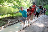 |
The first barefoot trail created in the Baltic States in the recreation complex "Valguma pasaule", which is located on the forested shores of Lake Valguma. When walking on the path, the feet "massage" sand, wood chips, clay, peat, gravel, cones and various other materials. |
|
 |
Varniku mežā (Varnikų miškas) ir izveidota patiesi interesanta dabas izziņas taka, kas iet cauri dažādiem biotopiem – skujkoku un ozolu mežiem, purvainu mežu un sūnu purvu ar akačiem un nelieliem purva ezeriņiem, kur uzceltas divas skatu platformas. Mitrajās vietās un purvā ir izveidotas koka laipas. Šī ir populāra pastaigu vieta. Taka ir lokveida un marķēta. Tās apskatei būs nepieciešama ~ pusotra stunda. |
|
 |
A marked hiking route (a guide will be needed) begins at the Jēči windmill, which was built in 1878. Nearby is a dendrology park and a collection of rocks. You will learn about moraines and other geological features in the region, study various kinds of swamps, see the unique piles of rock at Pugas, as well as the Kraujiņi rock. The route is 7 or 5 km in length, returning at the starting point, and it will take some four hours to traverse. Be sure to put on waterproof boots!
|
|
|
|
Atrodas mežā, netālu no Kaltenes. Labiekārtota (laipas, kāpnes, informācijas stendi) taka, kas iepazīstina ar Latvijai samērā neparastu dabas pieminekli (aizsargājams) – Kaltenes kalvām, kas ir lieli, līdztekus Rīgas jūras līča krasta līnijai orientēti laukakmeņu krāvumi. Uzskata, ka tos veidojuši Baltijas ledus ezera ūdeņi un ledi. Garums – ap 1,5 km. |
|
 |
Aptuveni 2km garā Ķirbižu meža izziņas taka izveidota apļveidā gar Vitrupes abiem krastiem. Visā takas garumā var mācīties atpazīt Latvijas mežu raksturīgākos kokus, krūmus un augus. Šeit var aplūkot arī Vālodzes dižozolu (6.5 m). Upes labajā krastā, pie tā sauktā vīna pagrabiņa un kreisajā krastā apmēram 200 m no takas sākuma pie Meža muzeja, atklājas ainaviski skati uz ieleju un Vitrupi. |
|
|
|
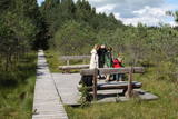
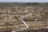
In 2006, a wooden pathway was installed across the Planči swamp – 500m long, which means that the visitor will spend around 20 minutes there. This is probably the only nature trail in Latvia for which there are plans to post information in Braille for people with impaired vision.
|
|
 |
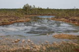
Teiči Nature Reserve — untouched territory, bogs, and birds. This is a significant bird resting place before seasonal migrations. Here you can see up to 1,500 cranes and 8,000 geese at once. The bog is a mating-place for black-cocks, therefore if you are near in an early spring, listen, and maybe you will hear these majestic mating calls. The trail can be visited only with the Nature Conservation Agency employee's escort from June 1 until October 31. |
|
 |
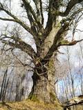
Dabas taka atrodas Zaķumuižā un ved cauri vecajam muižas parkam, pa ceļam iespējams aplūkot simtgadīgus kokus, dažādus augus, kā arī dažādus kukaiņus, putnus. Taka ir veidota kā mācību taka un to veidojusi Zaķumuižas pamatskolas skolotāja. Taka ir 1,5 km gara. Tai ir vidējas grūtības pakāpe: takas reljefs ir samērā vienmērīgs, mērens, izņemot atsevišķus posmus (daži stāvumi un kritumi, dažviet nelīdzens reljefs), tāpēc īpaša fiziska sagatavotība pirms takas iziešanas nav nepieciešama. Vietās, kur reljefs ir stāvāks, izvietoti roku balsti, bet pāri muižas dīķu sistēmas ūdeņiem uzcelti divi tiltiņi.
|
|
 |
4 km garā un marķētā taka iepazīstina ar dziļo Imulas ieleju – Abavas kreisā krasta pieteku. Īpaši iespaidīga ieleja izskatās bezlapu periodā, kad ir apjaušami tās izmēri un formas. Vēstures cienītāji var upes gultnē uzmeklēt Langsēdes Velna pēdas akmeni. Atrodas dabas parkā „Abavas senleja”. |
|
|
|
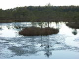
Taka ap Ozolu Mazezeru. Purvaino krastu posmā, ap ezera rietumu galu, ierīkotas gājēju laipas. Novērojami purva, meža un ezera augi, dzīvnieki un biotopi. Jūlija beigās īpaši krāšņi zied ūdensrozes. Blakus atrodas Ozolmuiža ar parku.
|
|
 |
The trail (the length 1.2 km) introduces with the habitats of dunes and century-old pines, partly covered with sand. Biologists estimate that the oldest tree, the “mother of pines”, could be around 200 years old. Coastal pine forests serve as a barrier between the sea and land protecting inland areas from impact of the sea and winds. Felling coastal forests was forbidden by law already back in 1643, during the Duchy of Courland. Still due to economic activities, the seashore forests were often fell and fires occurred there occasionally. As a result, the sand which had for centuries been hold by trees, started drifting at Cape Kolka. In the 1930ies, there were about 142 hectares of sandy areas in the Slītere National Park, and 11.5 hectares of those were drifting sand. To stop drifting, the sand areas were carefully afforested. Afforestation was started before WW I and it was completed in the 1970ies. To plant new trees, first the sand had to be stopped. Just 26km to the south from Kolka there was one of the largest sand dunes in Latvia, 25km in length. Every year it devoured 0.3 hectares of land. The sand was stopped covering it with heather, twigs and branches of pines and junipers. Pine trees were planted between them. Today in Kolka, the old, low pine trees tell about the once drifting sand. After storms, when the water washes the bluff and tree roots are exposed, one can see that the tree trunks once have been covered with sand more than 1 meter high. The trees on the seacoast usually have crooked trunks and flag-shaped crowns formed under influence of persisting sea winds. Now these forests are designated biotope “Wooded dunes of the coast”. Stable white dunes (biotope 2120) do not form in Cape Kolka as they are washed by sea waters during spring and autumn storms. Embryonic dunes develop here (code 2120) with plants that usually grow in dunes. These plants have adapted well to poor soils, heat, drought, and the saline sea water. The Kolkasrags Pine Trail is in Slītere National Park. |
|
 |
Informatīvi bagāta un interesanta dabas izziņas taka, kas ved pa Gaujas tuvumā esošajiem krasta biotopiem – boreāliem mežiem, nogāžu mežiem, gar vecupi, jauktiem lapu koku un platlapju mežiem, kā arī parkveida ozolu pļavām. Ziemeļgaujas aizsargājamo ainavu apvidū esošie meži ir vieni no sugām daudzveidīgākajiem Latvijā. Taka ir marķēta, izveidotas skatu platformas, izvietoti informatīvie stendi. Kopējais takas garums: 2,2 km |
|
 |
Bijušā piecstāvīgā metāla skatu torņa apkaimē plešas Lemmjegi upes palieņu pļavas. Netālu atrodas kādreizējā Oksas kroga (Oksa kõrts) vieta, kur saglabājies iespaidīgs manteļskurstenis. Apkaimes apskatei izveidota 0,8 km gara koka laipu taka. |
|
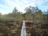 |
Here you can cross a swamp without getting your feet wet and enjoy the local environment, which has been little touched by humankind. You can take the dam of the former Smiltene-Valmiera-Ainaži narrow gauge railroad. It crosses the swamp from the South-East to the North-West and is three to four km in length. There is also a circular wooden pathway on the eastern side of the dam. The length of the trail (including the dam) is around 5km, and it will take 90 minutes to two hours to traverse. The area is covered by environmental restrictions.
|
|
 |
Iepazīstina ar Somā nacionālā parka lielākā purva – Kureso (Kuresoo) ziemeļaustrumu daļu, kur redzamas purva ezeriņu un lāmu ainavas. Takas sākumā atrodas igauņu komponista, ērģelnieka un folkloras vācēja Marta Sāra (Mart Saar) (1882. – 1963.) dzimtās mājas. To apkaimē pļavas apsaimnieko aitas. Lokveida takas garums ir 4,2 km. |
|
|
|
Nepilnus 3 km garā taka iepazīstina ar dziļo Imulas ieleju – Abavas kreisā krasta pieteku. Īpaši iespaidīga ieleja izskatās bezlapu periodā, kad ir apjaušami tās izmēri un formas. Viens no takas iespaidīgākajiem objektiem ir Buses jeb Matkules pilskalns. Apskatāmi citi objekti – Baznīckalns, Bedrīšakmens, Ķauķa kalns ar avotiņu. Atrodas dabas parkā „Abavas senleja”. |
|
 |
The Sunset trail starts in the centre of Saulkrasti town and takes you to the White Dune. Saulkrasti town with its municipal rural territory, occupies a 17km long stretch of coastal land to the North from the river Lilaste and the lake Lilaste. The White Dune stands on the right side of river Inčupe mouth. It is covered by old pine forest. The white, 18m high sand outcrop in olden times served as a landmark for fishermen. The White Dune formed as winds carried the sand from the beach over clay sediments of the Baltic Ice Lake. Some 150-200 years ago, the dune had been drifting as witnessed by several layers of soil buried within it. Local fishermen and farmers at Bātciems initiated afforestation of the drifting dunes. At that time, the 30m high dunes which are now covered with forest, were bare, shifting and even buried a farmstead. To speed up afforestation, mountain pines were planted. The White Dune was partly washed away in heavy storm in 1969, and 4-6m high precipice formed. Now the wind and sand have levelled out the dune surface, it has been fixed with willow-twigs or grown with forest where the largest pines are more than 170-190 years old. The pines are notable with their large trunks and branches, the scars obtained during their lifetime and the typical “crocodile skin” – the bark forms rhombuses resembling those of the reptile’s scales. Scots Pine (Pinus Silvestris) is one of the most common tree species in Latvia. It grows in dry, meagre sandy soil in dunes as well as in marsh. However, it does not stand overshadowing. Forest fires help pines to get rid of competitors as pine endures fire better than other trees because of its thick bark and high crown. The wood exudes resin and burned wounds close soon. Fire cleans space for seedlings of young pines. Pines can live 300-350 years. Ground cover in dune forests is very sensitive. If the sparse vegetation is destroyed, not only the natural biodiversity and landscape is damaged, but also the dangerous shifting dunes can possibly “wake up”. Embryonic dunes, White (yellow) dunes, Grey dunes and Wooded dunes are EU protected biotopes. Grey Dunes are protected by Latvian law as well. |
|
 |
Maršruts "Murjāņi - Līgatne" ved caur Gaujas senieleju ar devona smilšakmens atsegumiem, raksturīgo augu valsti un dzīvniekiem. Krastos sastopami Latvijā lielākie nogāžu un gravu meži ar liepām, ozoliem, gobām un ošiem. Upes līkumos palienē aug baltalkšņu un vīksnu audzes. Uz koku stumbriem atrodams plaušķērpis. Senieleja bagāta ar sausokņiem un kritalām, tāpēc Gaujas krastu mežos dzīvo visu Latvijā sastopamo dzeņu dzimtas sugu putni. Smilšainajās Gaujmalas pļavās un Gaujas vecupēs ir bagātīga bezmugurkaulnieku fauna. Upes krastos ir smilšakmens klintis ar čurkstu alām un zivju dzenīša ligzdām. Klinšu pakājē iztek avoti, kas uztur mikroklimatu ielejā. Gauja ir nozīmīga arī kā Latvijas lielākā lašupe. Maršruts ir daļēji marķēts un papildināts ar norādēm un informācijas stendiem. |
|
 |
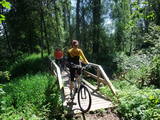
This is a route for hikers and bicyclists, starting at the village of Vaidava and then moving along the eastern shore of the narrow Lake Vaidava, which has steep cliffs around it. The trip covers the Veļķi baronial estate, the “Swedish pine”, the famous Vaidava (Metimne) hillfort, a series of streams, the great Rubene rock, the Vaidava baronial estate on the western shore of the lake. After that, the trail leads the visitor back to the starting point.
|
|
 |
Taka iesākumā ved pa mežu ieskautu bijušo šaursliežu dzelzceļa līniju, pa kuru pagājušā gadsimta vidū izveda kokmateriālus. Tās tālākā daļa izmet nelielu loku pa Suistna purvu (Suistna raba), kur uzcelts skatu tornis ar izcilu sūnu purva ainavu ar nelieliem ezeriņiem. Takas garums vienā virzienā ir 4,5 km. |
|
