
| No | Name | Description |
|---|---|---|
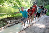 |
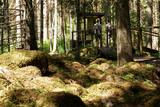
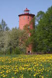
The first barefoot trail created in the Baltic States in the recreation complex "Valguma pasaule", which is located on the forested shores of Lake Valguma. When walking on the path, the feet "massage" sand, wood chips, clay, peat, gravel, cones and various other materials. |
|
 |
Lots of wild animals can be found in vast paddocks along the ancient Gauja river valley and its small tributaries – areas in which living conditions are as close to natural circumstances as possible. Here the visitor can find, if lucky, reindeer, deer, wild boars, bears, foxes, lynx, various kinds of birds, as well as aurochs. There is a dense network of pathways in the park, including lots of information. There is also a route for drivers and bicyclists. During the winter, it is used for distance skiing. There is also a visitors’ centre.
|
|
 |
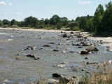
The most important aspect of the Sasaļi forest is the eutrophic Lake Sasalis, as well as the unusual Lake Melnezers. Also of importance are various types of forestland in the area. Lake Sasalis is a popular place for leisure and swimming.
|
|
|
|
2015. gadā uzceltais skatu tornis atrodas dabas parkā „Daugavas loki”, Daugavas ielejas kreisajā krastā – Daugavpils novada Vescalienas pagastā. No torņa aplūkojama izcilā Daugavas loku ainava. |
|
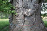 |
Most of the great tree’s mighty branches are gone, and among those that are still there, the thickest ones are held up by supports, and the tree’s hollow centre is protected against snow and rain with a little roof. This is the thickest Common Oak (Quercus robur) in Latvia and the Baltic States. Indeed, it is one of the thickest oak trees in all of Northern Europe. The tree is a gorgeous part of the surrounding landscape. There is a car park and an information stand nearby.
|
|
 |
The forest around Kaltene features a natural miracle – the rocks of Kaltene, which are also known as the barrier rocks. The rocks are 2-3 m from the sea and date back to the Ice Age. The Devil’s rock is the largest one. It used to be a beautiful pile of rocks that “stretched to the tops of the trees.” In older maps it is described as being 20 m high. It had many natural rocks, including some that were completely round, while others resembled plates. The rock was almost completely destroyed in the 1960s and 1970s, when it was chopped up to build roads. A fairly small part of the rock survives today, and it is 300 m long and 2 m high. Scientists believe that these rocks used to be sacred locations, because there are many legends and stories about them. There is a forest path with wooden pathways, information stands and a small car park there. (Source: Roja TIC) |
|
 |
Ap 200m garš un līdz 15m augsts ainavisks atsegums upes labā krasta asā līkumā. Tam iepretim otrā krastā (500m) Līgatnes dabas takas.
|
|
 |
This is a trail for hikers and bird-watchers, located in a very interesting place on the shore of the Bay of Rīga near Kaltene. The visitor will see small inlets and capes and a rocky or overgrown shore. At the end of the trail there is a bird-watching tower. During the spring and autumn migrations of birds, the visitor will see a great many different kinds of birds in the area – geese, plovers, etc. The length of the track is a bit more than one kilometre, and it will take 20 minutes to an hour to cover.
|
|
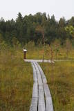 |
The small Andrupene swamp is found to the North of the Andrupene Farm Museum in a deep area between hillocks. It is a high-type swamp with an open central part, and it is 130 m long and 120 m wide. There are stands of white alder alongside the swamp. In 2009, the administrators of the Rāzna National Park restored a wooden educational pathway that had been established originally by the Andrupene Elementary School. Today there are stairs, a viewing platform, wooden pathways, and information stands. |
|
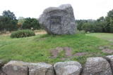 |
Pāvilostā ir trīs parki. Pāvilostas centrā (pie kultūras nama) atrodas Piecdesmitgades parks, kuru 1929. g. iekopa skolotājs un novadpētnieks Ernests Šneiders. Vienu ozolu tajā esot iestādījis Latvijas Valsts prezidents Gustavs Zemgals. Simtgades parks ar piemiņas akmeņiem tapa Sakas labajā krastā jau kā turpinājums iesāktajam. Vecākais no Pāvilostas parkiem - Upesmuižas parks (19. gs.) atrodas tuvu Liepājas – Ventspils šosejai. Upesmuižas pils nav saglabājusies (nodedzināta 1905. g.). Parkā apskatāms sens akmens sols (perimetrs 5,55 m) un Upesmuižas parka Lielais akmens. Domājams, tas ir kultakmens. |
|
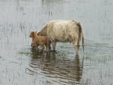 |
The shallow and mostly overgrown (65% of its surface) Lake Engure is one of those Latvian lakes which are most favoured by birds. It is a location which is governed by the Ramsar Convention on Wetlands, and 186 species of nesting birds have been identified there. The area is also distinguished by great botanical diversity (more than 800 kinds of plants). The coastline varies between sandy beaches and seashore meadows. There are forests, fishing villages and damp areas which ensure a great diversity in landscapes and species. The flood-land plains of the lake and the sea are grazing grounds for wild livestock – horses, blue cows, etc. Several bird-watching towers are open to visitors, as is the Orchid trail. The Centre for Ornithological Research is located on the eastern bank of Lake Engure. A unique floating house built by ornithologists is located on the lake. The territory is appropriate not just for holiday-makers, but also for hikers, bicyclists and bird-watchers. A leisure area and a small exhibition are located close to the ornithological research centre. |
|
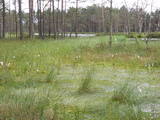 |
This is one of the largest areas of swampland in Latvia, lying between Lake Babīte and Olaine. Most of the area is still made up of peat. Relatively untouched is the northern part of the swamp, where there is a lovely set of swamp lakes, featuring landscapes of moss swamps. The heath is one of the few swamps in Latvia where the western-type and eastern-type swamp coexist. This is an important location for protected birds. A nature trail and viewing tower are to be installed at the heath in the near future.
|
|
 |
Nacionālā parka galvenā ainavas dominante. Ezers ir ~ 8,4 km garš un līdz 3,3 km plats. Tā austrumu krasti pārsvarā ir ar mežiem apauguši, ziemeļrietumu krasts – purvains, bet rietumu krastā parādās apdzīvotas sētas un simpātiskā Plateļu (Plateliai) pilsētiņa, kur meklējamas skaistākās skatu vietas. Ezera krastos ir labi attīstīta infrastruktūra - tūristu mītnes, ēdināšanas uzņēmumi (Plateļos), ūdenssporta un atpūtas inventāra noma. Ūdens dzidruma dēļ, Plateļu ezeru ir iecienījuši zemūdens niršanas entuziasti. Ezerā ir vairākas salas, no kurām interesanta ir Pils salas (Pilies sala), uz kuras no 15. – 16. gs. atradās muiža. Pastāv uzskats, ka senie Plateļu apkārtnes iedzīvotāji sākotnēji ir dzīvojuši uz salas, kuru ar krastu savienojis uz pāļiem celts tilts. Jāpiemin, ka 15 gs. pirmoreiz pieminētā Plateļu pilsētiņa atradusies uz Šventorkalņa (Šventorkalnis) kalna. Apkārt Plateļu ezeram ir izveidots ~ 24 km garš velomaršruts. Tā ir ļoti laba iespēja iepazīt parku videi un ceļotāja veselībai draudzīgā veidā. |
|
 |
Nature restricted area is established to protect various wetland habitats – Big Kirba Bog and protected plant species within it. Only the West part of the Bog is a protected nature area. The rest of the bog is used mainly for intensive extraction of peat and large cranberry cultivation. Nature restricted area of the bog has no tourism infrastructure therefore is not useable for tourist visits.
|
|
 |
is the second oldest navigation structure in Latvia and the only one that is five kilometres from the shore, at the upper edge of the ancient Lake Baltic Ice. Since 2000 the lighthouse has not served its initial purpose, and now it is the home to the Nature Education Centre "Slītere" of the Slītere National Park. The centre offers exhibitions about lighthouses in Latvia and the history of the Baltic Sea. From the upper floor (102 m above sea level) one can see the coast of Saaremaa (approximately 33 km away). Alongside the lighthouse is the 1.2 km Šlītere nature trail. |
|
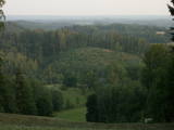 |
From the highest point in the Alūksne highlands, you will see an unusually beautiful view of the surrounding forested hillocks and the small areas of meadows and farmland. Sadly, there are no improvements to the location, which can be difficult to access. It is on private property.
|
|
|
|
Metāla tornis Kazari upes kreisajā krastā, ~ 5 km attālumā no Matsalu līča. No torņa redzamās Kazari deltas palieņu pļavas atrodas tikai 0,3 – 1 m augstumā virs jūras līmeņa, tādēļ pavasara palos un stipru vētru (īpaši rietumvēju) laikā ūdens appludina milzīgu teritoriju. Uzskata, ka platības ziņā šīs ir vienas no lielākajām Eiropas palieņu pļavām, kas ir nozīmīga dažādu tārtiņveidīgo putnu sugu ligzdošanas, dzērvju un zosveidīgo putnu atpūtas un barošanās vieta. Ir pagājis laiks, kad zemnieki Matsalu pļavās ganīja govis un pļāva sienu, tādēļ šobrīd pļavu apsaimniekošanu veic nacionālā parka administrācija. |
|
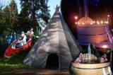 |
The Centre promotes sustainable lifestyle and the great outdoors, there you can plant trees and make and install nest boxes. Canoeing, bog walks, bow and crossbow shooting ranges are available for the more adventurous. There is a log house for functions and accommodation and a sauna with a hot tub. |
|
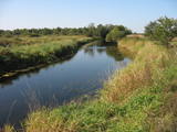 |
Palieņu un mitrās pļavas abos Dubnas upes krastos, kuras nelielā posmā var vērot no Rožupes - Vārkavas ceļa. Piemērotā laikā šeit dzirdēsiet griezes balsi, kas ir Eiropā izzūdoša putnu suga.
|
|
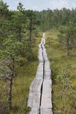 |
Ein 3,5 km langer Pfad quert den Viru Moos in Richtung Süd–Nord. Von einem Holzaussichtsturm eröffnet sich einen Blick auf eine typische Hochmoorlandschaft mit einigen Seen, Aushöhlungen und morastigen Stellen. |
|


