
| Нo | Название | Описание |
|---|---|---|
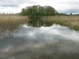 |
Dabas liegums veidots ezera, tā salu, ainavas, augu, putnu un sikspārņu aizsardzībai. Liegumu var apskatīt "no malas" - no ceļa, kas iet gar tā ziemeļu un ziemeļaustrumu robežu.
|
|
 |
Лустужкалнс в 16 ст. на высоком холме
(72 м н.у.м.) находился охотничий замок
магистра Ливонского ордена Вальтера фон
Плетенберга. В свою очередь, построенный
во время Русской императрицы Екатерины
дворец развлечений, от которого и пошло
название и легенда о затонувшей золотой
карете в озере Валгума.
|
|
 |
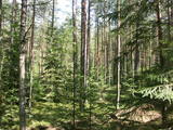
These are hillocks at the northern end of the Vidzeme highlands, and this is an important location for boreal (Northern) forests and swamps. Various kinds of swamps are found here, and the area is home to a variety of protected invertebrates.
|
|
 |
Ботанический сад является подразделением Шяуляйского университета. Это самый молодой и самый небольшой по площади ботанический сад в Литве. Сад был заложен в 1958 г. Его общая площадь составляет 6,54 га. |
|
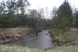 |
Nature restricted area is located to the South from former railroad Ventspils-Liepaja and includes approximately 6 km of Uzava River (and the old drainage system). The territory was used for agriculture during Soviet time, now it starts overgrow by scrubs. The protected nature values – rare bird species, including corncrakes, variety of grassland habitats and plant species. Territory is not useable for tourism activities. There is a possibility to get good insight into the North part of restricted area from the road Alsunga – Berzkalns where information stand is located.
|
|
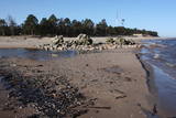 |
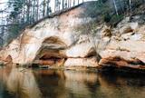
Наиболее выраженный мыс латвийского побережья, откуда видно место соприкосновения волн двух морей – Балтийского моря (Великого моря) и Рижского морского залива (Малого моря). Во время шторма здесь бьются друг о друга волны высотой до 7 метров. Мыс в виде подводной мели протянулся на расстоянии 5 км до Колкского маяка. Маяк построен на искусственном острове, который был насыпан в 1872 - 1875 гг. Когда остров осел, в 1883 г. на этом месте построили теперешнюю 21-метровую башню маяка (изготовлена в Санкт-Петербурге), которая начала действовать 1 июля 1884 г. В наши дни на острове находится здание смотрителя маяка и несколько хозяйственных построек, а также внушительный колокол на случай тумана. В Колкасрагсе установлен памятник работы скульптора Г.Бурвиса «Забранным морем», можно осмотреть остов деревянного корабля (предположительно 19 в.), камень - Сердце Европы (K. Валдемар считал это место центром Европы), информационные стенды, посвященные К. Валдемару, и базусил береговой охраны армии бывшего СССР, которую служба пограничной охраны Латвии использует и в наши дни. Во время миграции Колкасрагс – это важное место концентрации и отдыха перелетных птиц в Североевропейском масштабе. В Колкасрагсе создан центр для посетителей, и работает летнее кафе. Необычны сосны, вымытые штормами на пляж! В окрестностях Колкасрагса под водой находится крупнейшее в Балтийском море кладбище кораблей. Для пловцов – это опасное место из-за изменчивых течений и подвижного песка! В конце Колкасрагса можно осмотреть развалины Старого маяка - остатки построенной в XVIII столетии южной башни (северная башня вымыта во второй половине XIX века). |
|
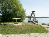 |
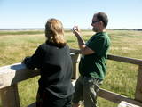
Viewing tower on pontoons, and there is a footpath to get to it. The tower offers a view of nearly all of Lake Sloka, all the way to Kauguri. Particularly visible is the northern part of the lake. There is also a sulphur spring. The site is good for bird-watching throughout the year, including the winter, because parts of the lake do not freeze over. |
|
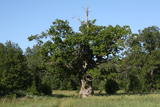 |
The tree is in the middle of an untended field. Despite many dead branches and the messy surroundings, the tree is beautiful and well visible from the road. It is the third thickest tree in the Baltic States.
|
|
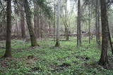 |
One of the rare places (see also Rucavas ivju audze) in Latvia where two rare and protected wild tree species grow - yew-tree and Baltic ivy. Territory is not marked on site with information signs or stands therefore it is hard for visitors to find. Not usable as tourism object.
|
|
 |
Vienu kilometru garā lokveida taka, kas ved pa lielāku nacionālā parka meža masīvu, uzskatāmi attēlo Žemaitijas augstienes un tuvākās apkārtnes reljefa veidošanās vēsturi. No takas augstākā punkta – Mikitai kalna, kas ir sens pagānu upurkalns, paveras (ainaviska stiga) tālākas apkārtnes skats. Kā takas interesantākie apskates objekti ir jāmin teikām apvītais akmens ar Velna pēdu un ar akmeņiem izliktas akas paliekas. |
|
 |
Dabas liegumā ietilpst divi aizauguši ezeri ar grūti pieejamiem krastiem - Lielais un Mazais Asūnes ezers, kas atrodas dienvidos no Asūnes ciema. Abus ezerus var vērot, atrodoties ārpus lieguma teritorijas - no blakus esošo pauguru augstākajām daļām, kas atrodas austrumos no abiem ezeriem. Ja līdzi būs paņemts tālskatis, iespējams, izdosies iztālēm novērot šeit esošās aizsargājamās putnu sugas, piemēram, melno zīriņu. |
|
 |
Place for bird ringing and bird watching. |
|
 |
Местность Тухала была заселена почти 3000 лет назад. Здесь 11 древних поселений, 30 культовых камней, 3 каменных могильника, 4 культовые рощи и т. д. В ландшафтном заказнике Тухала располагается и уникальный Ведьмин колодец, который во время большой воды «кипит», выливая 100 литров воды в секунду, а также 5 мощнейших энергетических столбов в Эстонии. |
|
 |
This is one of the most beautiful ancient river valleys in Estonia – 12 km long with nearly 40 revealed Devonian sandstone cliffs. Among these, the most important ones are Viira müür, Kalamatu müür, and Põdramüür.
|
|
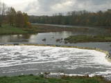 |
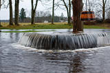
The recently renovated old brick bridge and the viewing area that is on the left bank of the Venta beyond the castle guard’s hut offers a lovely view of the widest and most impressive waterfall in Latvia – the Venta falls. It is worth visiting during the spring floods, when fish are migrating.
|
|
 |
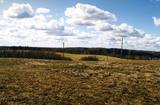
The Kurzeme Peninsula has the largest landscape of hillocks and valleys in Europe in the shoreline segment from Melnsils and Kolka to Oviši and Liepene. It is a unique landscape in Latvia, and part of it is in the Slītere National Park. The Pēterezers Nature Trail offers the best chance to look at the landscape. There are hillocks and valleys elsewhere, too – near shoreline villages where the Kukšupe valley (one of the longest ones – 8 km in all) is crossed by the Ventspils-Kolka highway, as well as near Apakšceļš. The only thing is that you need to learn how to spot the areas out in nature. |
|
 |
This is not a well known castle hill, but it offers one of the most unusual views of Lake Lielezers of Augstroze. There are ruins on the castle hill, and a short hiking trail has been installed to look at them. This is part of the ZBR.
|
|
 |
The viewing tower is in a seaside meadow near Mērsrags. It is an unusual type of biotope in Latvia and is located to the North of the Mērsrags port. The tower offers a good view of reed-filled meadows, areas where wild cattle have grazed, and an amazing wealth of different kinds of plants. |
|
 |
No ģeogrāfiskā un kultūrvēsturiskā viedokļa interesanta teritorija Latgales augstienes Rāznavas paugurainē, kuras nozīmīgākie resursi ir dažāda veida biotopi, ainavas, reljefs un Šķaunes ezers. Istras pauguraines dabas parkā nav ar tūrismu saistīti labiekārtojumi, bet šo teritoriju var apskatīt arī „no malas”, braucot pa grantēto ceļu no Soboļinas uz Osinovku, kas iet līdztekus parka ziemeļu robežai (skats uz Šķaunes ezeru).
|
|
 |
Ap 25 km gara un līdz 1,5 m plata vaļņveida reljefa forma Adzeles pacēluma dienvidu malā, kas apaugusi ar skujkoku mežu. Latvijā reti biotopi un nozīmīga daudzu aizsargājamu augu un dzīvnieku sugu dzīves vieta. Numerenes valni var ļoti labi "izjust", braucot pa Kārsavas - Tilžas ceļu. Dabas parkā atrodas slēpošanas kalns "Nūmerene".
|
|


