
| Нo | Название | Описание |
|---|---|---|
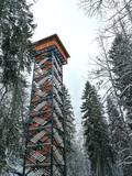 |
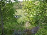
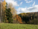
Dabas liegumā "Lielie Kangari" atrodas 33 metrus augsts skatu tornis, kura virsotnē atrodas platforma, no kuras paveras skats uz Kangaru ezeru un Lielkangaru purvu. Dabas liegumā izbūvēta arī nepilnu divu kilometru gara pastaigu taka ar tiltiņiem un skatu platformu pie ezera. Takas sākumā izvietotais veselības maršruts ikvienu apmeklētāju aicina kārtīgi izvingroties un izkustēties. Apmeklētāju informēšanai un izglītošanai visas takas garumā izvietoti arī informatīvie stendi ar fotogrāfijām, kas apvieno varenu stāstu un teiku kopumu par notikumiem, vietām, tēliem un parādībām dažādās apkārtnes vietās. |
|
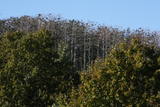 |
Aiz Jodkrantes (Nidas virziens) ceļa labajā pusē ir izveidots autostāvlaukums un labiekārtota vieta, no kuras apskatāma Lietuvas (atrodamas ziņas, ka arī Eiropas) lielākā zivju gārņu Ardea cinerea un jūras kraukļu Phalacrocorax carbo kolonija, kur kopā varētu būt ~ 3000 putnu. Neaizmirstiet līdzi paņemt tālskati! |
|
 |
This is the first national park in Estonia and the Baltic States. Perfect for a day trip out from Tallinn for a hiking trip and nature watching. It was established in 1971 to protect the area that is along the Bay of Finland – the shoreline, forests, swamps, meadow biotopes, species, natural monuments, rocks, waterfalls, cliffs and cultural monuments such as ancient cemeteries, castle hills, baronial estates, fishing villages, etc. |
|
 |
This arboretum is in a lovely location in the Vidzeme highlands. It covers 140 hectares of land and offers a look at interesting coniferous trees, lianas, lilacs, rhododendrons and peonies. The facility has a modern visitor information centres.
Unique species: The Tulip Tree (Liriodendron tulipifera), the Fringe Tree (Chionanthus virginicus), and the Kobushi Magnolia (Magnolia kobus).
|
|
 |
This is a segment of the Gauja River which is full of rapids in some places. It stretches from Vidaga and the place where the Vecpalsa River flows into the Gauja. Along the Gauja and its tributaries, dolomite outcrops can be seen on the shores, and the largest of these are the Randati cliffs. The restricted area was established mostly to protect various kinds of forests, meadows, outcrops and their habitats. This is an interesting part of the central section of the Gauja for people who enjoy beautiful landscapes and for those who are water tourists.
|
|
 |
This is an uncommon landscape for the Kurzeme region with a protected biotope – open inland dunes with meadows of silver grass and forests of deciduous trees, including the common hornbeam. Tourists can visit the Muiža (Lejas) sacred stream on the right bank of the Sventāja valley, above which they will find Latvia’s most noble bird-cherry trees. A nice reed pergola has been installed above the stream. Wide are of Sventāja River valley can be overseen from the road before the stream. |
|
 |
Iespaidīgs pilskalns ar izveidotu apskates taku. Blakus ūdenstūristu apmetne „Kvēpene”.
|
|
 |
Парк усадьбы Ренавас, заложенный в XIX в., представляет собой один из литовских парков репрезентативного типа и сохранил свое первичное природное начало. В небольшом партере дворцовой части парка сохранилось немало экзотических пород деревьев. В северной части парка и в лесопарковой зоне преобладают клены, липы, ясени, ели, дубы и др. Украшением парка является самая толстая ель в Литве: ствол этого дерева достигает 1,2 м в диаметре. Также здесь растет необычная липа: ее главный ствол некогда сильно накренился, и сейчас на нем растут шесть отдельных деревьев, отпочковавшихся от основного ствола. В парк ведет так называемая пергола (крытая аллея), увитая вьюнком. |
|
|
|
Pie dažus metrus augstajām klintīm pavasaros un pēc
lietavām veidojas divi nelieli sezonāli ūdenskritumi.
|
|
|
|
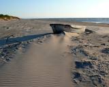
In terms of territory, it is the most impressive dune range in the Baltics. This is the only place in the Baltics, where one can enjoy open dune sands that are still active and, under the influence of wind, form the so-called eolian relief forms. There are trails, wooded trails and a paved bikeway for the conveniences of visitors. In order to protect the dune, The Dunes of Curonian spit National Park has been established . |
|
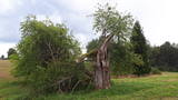 |
This is the thickest European wild apple tree in Latvia. It is just lovely when it is blossoming.
|
|
|
|
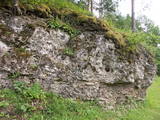
Iespaidīga smilšakmens atsegumu virkne, kas
izveidojās pēc 2005. g. orkāna.
|
|
 |
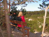
The viewing area is near the top of the Vilce castle hill, with a view of the Rukūze River valley, Zaķi meadow, and surrounding forests. This is an unusual landscape for the region of Zemgale. The Vilce baronial estate is nearby.
|
|
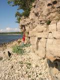 |
Nacionālā parka dienvidrietumdaļā jūrā iestiepjas Eldas pussala – skaists un ļoti omaļš ar kadiķu mežu (alvāriem) noaudzis zemes pleķītis ar interesantu jūras krastu, kur atsedzas silūra perioda nogulumieži. No pussalas gala, kurā slejas vecs Padomju armijas robežsargu tornis (apmeklējumam bīstams!), paveras visaptverošs skats uz Vilsandi salu (atpazīstama pēc bākas), Lonalaidas salu (Loonalaid) – otru lielāko Vilsandi arhipelāgā, Salavu (Salava) un citām mazākām saliņām. Dabas mīļotāji var uzmeklēt Eldas klinti (Elda pank) – ~ 2 m augstu un 0,4 km garu atsegumu, kura piekājē var atrast interesantas ūdens izskalotas fosilijas. |
|
 |
One of the highest dunes in Latvia, located between Bernāti and Jūrmalciems villages. It is 37m high and offers a magnificent view of the sea and natural pine forests. The highest dunes in Latvia stand to the South of Jūrmalciems village: the Pūsēnu hill, the Ķupu hill, the Mietragkalns or Tiesas hill, the Pāļu hill, the Garais hill, the Ātrais hill, the Lāvas hill. The Pūsēnu dune is the highest of these dunes which are all called hills by the local people. The Pūsēnu hill developed between 1785 to 1835 when shifting sand became extremely dangerous. Several homesteads were buried in sand, among them „Pūsēni”, where a forester’s family lived. The family is said to have moved to Bārta. The dune was named after the buried homestead. Jēkabs Janševskis, a Latvian writer, wrote in his book „Nīca”: “In olden times, large pine trees were growing in the dunes on the coast of Nīca and they stood steady and firm. But i Swedish times (around 1650), the Swedes built a large kiln for charcoal and tar. Pine wood and stumps provided an excellent material for this. Once a big fire rose, and the charcoal kiln burned down as well as the whole pine forest. The remaining stumps and bare trunks in the vast burnout could not hold the storm-driven sand; it flew further and further burying not only the burned-out forest, but also the nearest fields. In wintertime, when the vast, low marshy grasslands were covered with ice, jets of sand drifted further over its surface, and soon most of the grasslands and large meadows turned into sandy heath-land and dunes.” To reconstruct Liepāja, severely damaged during WWII, a silicate brick factory was built in the town. The main raw material was white sand and it was taken from the Bernātu forest. In the 1960-ies they started to dig off the Green Dune and the White Dune, later also the Pūsēnu hill. The excavators used to work day and night, in three shifts. The work stopped at around 1980, as there was no more sand suitable for production of brick. A trail is set up to facilitate walking in the Pūsēnu Dune in the Bernātu Nature Park. |
|
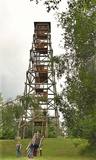 |
Lielais Liepu kalns ir Latgales augstienes Rāznavas pauguraines augstākā un Latvijā trešā augstākā virsotne (289,3 m v.j.l.). Lielpaugura relatīvais augstums ir 86 m! Skatu torņa platforma ir šobrīd augstākais Latvijas punkts (323 m.v.j.l.), kas sasniedzams ar paša kājām! Liepu kalna apkārtne ir labiekārtota. |
|
 |
The Krustkalni Nature Reserve was established in 1977, and the diversity of plants in the region is based both on the terrain – the Madona-Trepe embankment, a series of hillocks with low areas among them, swamps and small lakes – and on the biotope – natural meadows, forest glades, places where underground streams bubble up to the surface, and vast areas of forest with very old stands of trees. Some 800 types of plants have been defined in the reserve. It can be toured only in the company of a guide from reserve headquarters, and one must apply in advance. Visitors can visit the Krāku streams, Lake Svēte-Dreimaņi, and other sites. |
|
 |
Валгумс или седумс – так называлась песчаная прибрежная полоса между дюнами и водой, где стояли лодки и сушились сети. Каждому селению принадлежало несколько пляжей, которые в 20-30 г.г. 20 века имели большое значение для сохранения языка ливов. |
|
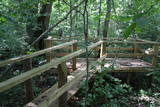 |
Informatīvi bagāta un interesanta dabas izziņas taka, kas ved pa Gaujas tuvumā esošajiem krasta biotopiem – boreāliem mežiem, nogāžu mežiem, gar vecupi, jauktiem lapu koku un platlapju mežiem, kā arī parkveida ozolu pļavām. Ziemeļgaujas aizsargājamo ainavu apvidū esošie meži ir vieni no sugām daudzveidīgākajiem Latvijā. Taka ir marķēta, izveidotas skatu platformas, izvietoti informatīvie stendi. Kopējais takas garums: 2,2 km |
|
 |
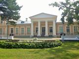
Парк поместья «Засас» раскинулся по берегам мельничного пруда (в северной части Засас), образовавшегося вследствие запруды на речушке Засас. Формирование парка относится к 18 столетию, а сам парк создавался в романтическом стиле пейзажных парков. Одновременно с парком начиналось и строительство господской усадьбы «Засас». Ее владельцем был Генрих фон Засс, именем которого назван район Риги Засулаукс. В 19 веке, когда сменился владелец господской усадьбы, имение «Засас» считалось одним из наиболее богатых и наикрасивейших имений в окрестностях. Обязательно погуляйте по широкому парку с многочисленными мостиками, деревом Оборотней, Чертовым камнем и святым источником. Осмотр парка господской усадьбы в сопровождении гида: +371 26337227.
|
|


