
| Нo | Название | Описание |
|---|---|---|
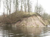 |
Where the little Rumbiņa river flows into the Daugava (on the left bank of the little river opposite the Lielvārde park), there is the Dievkalns castle hill that has been reduced by the waters of the Daugava. It is also known as the Cepure hill. According to antiquities that have been found here, representatives of Baltic tribes lived here from the first millennium BC to the 6th or 7th century AD. The level of the Ķegums hydroelectric power plant can be reached by a staircase from which the best view of this object can be found.
|
|
 |
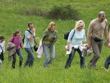
Here the visitor will find an ecological tourism trail in the ancient Embūte valley. The hills around Embūte date back to the Ice Age. There are valleys and forests of many fallen trees which are protected habitats. The visitor will learn about important natural and cultural monuments – the Embūte castle hill, as well as the ruins of a baronial estate, a castle and a church. The Courlandian chieftain Indulis died in the region. The visitor can view the Devil’s Dam, along with meadows, a viewing tower, etc. There are bicycler routes in the region. The site is located in the Embūte nature park. |
|
 |
Augstrozes pilskalna taka atrodas ainaviskā vietā, gleznainā 13. gadsimta pilskalnā, kas apvīts ar teikām un leģendām. No pils drupām paveras labākais skats uz lielisko ainavu, ko veido Augstrozes Lielezers un Ziemeļu purvi.
|
|
|
|
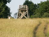
Atrodas sporta un atpūtas kompleksā „Trīssaliņas”. No torņa paveras pievilcīga apkaimes ainava, kas īpaši skaista ir pieneņu ziedēšanas laikā. |
|
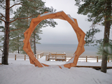 |
A new section of the walking trail along the sea has been built and an environmental object "Sunset watcher" has been created in Saulkrasti near the White Dune and Sunset Trail. It is a photo object where the newlyweds and every guest of Saulkrasti can capture memories in the symbol of the sun, which is so characteristic of Saulkrasti. |
|
|
|
Meklējams pie Gulbjiem – Dvietes senlejas informācijas centra. No torņa labi pārskatāma ūdeņiem bagātos pavasaros pārplūstošā Dvietes paliene, dzīvei savvaļā pielāgoto mājlopu aploki un izlīkumotā Dvietes upīte. |
|
 |
The restricted area was established to protect this part of the Ogre River valley, which has ancient river beds and meadows with relevant biotopes and populations. Among these are the wych elm and the European white elm, which are not often found in Latvia.
|
|
 |
Ūla ir viena no skaistākajām un likumsakarīgi – arī populārākajām Lietuvas ūdenstūristu upēm. Tās galvenā pievilcība ir skaistā ainava ar augstajiem upes krastiem, kuros slejas iespaidīgas smilšu kraujas līdzīgi kā Irbes krastos Latvijā. Laivošanu var sākt no Mančagires (Mančiagirė) vai Zervinos ciemiem un turpināt līdz Ūlas ietekai Merķē un tālāk pa Merķi līdz pat Merķinei un Nemunai. Ūla nav plata, taču posmā no Zervinos ciema tajā nav neviena koku aizgāzuma vai cita šķēršļa, kuram laiva būtu jānes apkārt. Ašā straume, asie līkumi, dzidrais ūdens un tajā redzamā zemūdens pasaule rada patiesi patīkamu sajūtu! Upes krastos atrodas gan publiskas (apsaimnieko Lietuvas valsts meži), gan privātas ūdenstūristu apmetnes un atpūtas vietas. Šī ir vienīgā Baltijas upe, kur ūdenstūristiem ir jāpērk licence. Ūlas krastos atrodas divi interesanti apskates objekti – Ūlas atsegums (Ūlos atodanga) un spēcīgs avots – Ūlas acs (Ūlos akis). Savukārt, Merķe jau ir jau krietni platāka upe, taču ar acīm redzamu straumi un dažviet pat jaukām straujtecēm. Kaut arī Merķes krasti ir mazapdzīvoti, tajos atradīsim piemērotas nakšņošanas vietas. Pa Ūlu un Merķi no Zervinos līdz Merķinei sanāk „mierīgs” pusotras - divas dienas ilgs brauciens. |
|
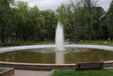 |
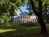
Mūsdienās redzamais parks starp Rīgas un Parādes ielu tapa vairāk nekā pirms 100 gadiem un tā patrons bija pilsētas pirmais mērs - Pāvels Dubrovins (1839. – 1890.). Pilsētas „zaļā saliņa”, kuras centrā atrodas strūklaka, ir iecienīta atpūtas un pastaigu vieta. Atraktīvs ir no bronzas veidotais piemineklis (2007. g., tēlnieks A. Tartinovs),kas veltīts pilsētas pirmajam mēram. |
|
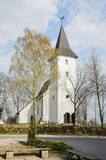 |
Церковь построена примерно в 1680 г. и больше чем через столетие перестроена - 1792 г. Храм и его ценный интерьер погибли во время Второй мировой войны, и только в 90-х годах прошлого столетия храм пережил восстановление в исполнении воспитанников Рижской Ремесленной средней школы. В 2005 году была благоустроена церковная башня, и посетители храма со смотровой платформы могут ознакомиться с местом, откуда Приекульский Икар выполнял свой первый «полет». Рассказывают, что в 1670 году кузнец господской усадьбы швед Йохансонс спустился с церковной башни на самодельных крыльях. За это его сожгли на костре! |
|
 |
Peat moss has been extracted from the Seda heath since the middle of the last century, but it is nevertheless one of the most important NATURA 2000 territories in Latvia, with a great diversity of landscapes, biotopes and biology – birds in particular. This is a good place for bird-watching during migration season, and viewing towers have been set up on the edge of the swamp for this purpose.
|
|
 |
Усадьба Салос и ее парк расположены на острове озера Двирагис, чьи контуры с высоты птичьего полета напоминают силуэт Литвы на географической карте. В восточной части усадьбы находится парк смешанной планировки. Это один из старейших парков в Литве. Еще во времена хозяйствования Радзивиллов здесь был лесопарк с запретом на вырубку деревьев. В парке преобладали лиственные деревья местных пород: клены, липы, ясени, тополя сереющие, которым сейчас сравнялось двести лет. По берегу озера проходила тропа, соединявшая аллею с парковой дорожкой. Сегодня здесь сохранились зеленые насаждения, фрагменты аллей. |
|
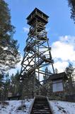 |
This recently built 26-metre wooden tower is on Ūdri Hill (58 metres above sea level). It is on the north-eastern shore of Lake Usma, less than one kilometre from the lake. The tower offers an excellent view of Lake Usma, its islands, and the vast forests which surround it.
|
|
 |
Вершупите – улицу Броценю пересекает Вершупите,
которая петляет через город Кемери. Над водной
«пучиной» речушки переброшено 10 маленьких и
романтических мостиков. Каждый из них имел свое
название.
|
|
|
|
Latvijas Valsts mežu laivu bāzē, kas atrodas Kaņiera ezera dienviddaļā (redzama no Lapmežciema – Antiņciema ceļa) kopā ar laivu bāzes ēku apvienots skatu tornis, no kura lieliski pārredzama ezera austrumdaļa. |
|
 |
An important complex of the coastline and its sand dunes along with the mouths of three major rivers – the Lielupe, the Daugava and the Gauja. This area has ancient traditions of recreation and spa services. The territory has lovely shoreline landscapes and features one of the few coastline meadows in Latvia. The nature park includes several restricted areas – the meadows of the Lielupe estuary, Vakarbuļļi, Daugavgrīva, Vecdaugava and Ummis (see the section on “Restricted Natural Areas”). Interesting elements of nature in this area include the amphitheatre of the Garciems dunes, along with individual dunes such as the Legzdiņi dune and the so-called ski mountain dune. Visitors will be attracted by various cultural and historical monuments – fortifications on the Mangaļi peninsula, military buildings from the period of the Russian tsars all the way through the late period of the Soviet occupation, the fortress of Daugavgrīva, the Vecāķi spa with its old shoreline buildings, and the beaches at Daugavgrīva and Vecāķi. The proximity of the city of Rīga and various important recreational resources are the reason for the massive anthropogenic burden that is placed on this territory. The nature park is appropriate for active tourism (hiking, bicycling, boating, driving), distance skiing, nature and bird-watching, cultural tourism, passive leisure and educational tourism. There are nature trails at Daugavgrīva and the Rožu dunes, along with other elements of infrastructure. |
|
 |
Dabas liegumā "Pilskalnes Siguldiņa" ir izveidota dabas taka - kājinieku tūrisma maršruts – t.s. Augšzemes ainavu taka, kas sākas Pilskalnē un beidzas pie Driģeņu mājām. Tā izlīkumo ezeru krastus, šķērso purvu (laipas). Apmeklētājiem, t.sk. arī bērniem, izveidotas arī īsākas - lokālas takas. Pieejami dažādu taku garumi: 1,6 km, 3,8 km, 8 km. |
|
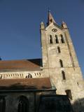 |
The tower of St John’s Lutheran Church in Cēsis, which is one of the oldest stone buildings in Vidzeme, offers a view of the historical centre of Cēsis, and a wide area all the way to Zilaiskalns Hill. There is also the western tower of the ruins of the Cēsis castle, one of the strongest fortresses of the Livonian Order in the Baltic region, and it offers a grand view of the castle’s park.
|
|
 |
An all-encompassing view of the urban environment next to the Daugava River valley is offered at the car park which is at the start of Augusta Street on the boundary of Krāslava. The unique wooden buildings of the area (the Kaplava Street region) can also be seen on the bridge which crosses the Daugava. Climb Karņickis Hill and hike through the park of the Plāters family of nobles. From there, you will see more local scenes.
|
|
.JPG?size=160) |
This park was established mostly to protect a wide range of cultural and historical objects such as the Trakai lake castle, the ancient Trakai cloister, the Užutrakai castle, the Bražole castle hill, the heritage of ancient local tribes, etc.
|
|


