
| No | Name | Description |
|---|---|---|
 |
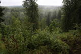
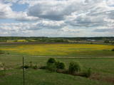
This is the highest point in the Latgale highlands (289 metres above sea level), opening up a narrow but lovely view of Lake Rāzna and the massive forests of the highlands. You really should visit this hill when the sun is setting beautifully!
|
|
 |
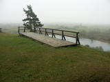
At the highest point of Krievkalni (149 metres above sea level), there is a good location for relaxation which offers an impressive view toward the East.
|
|
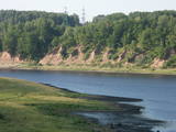 |
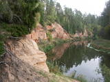
In Aizkraukle, drive down Enerģētiķu Street to the Selonian side (there will be small “pockets” at the side of the road) to see one of the best views of the Daugava River valley, reminding us of what this fateful river was like before the power plant was built. You will see that the river has eroded the steep cliffs on the right bank. The further part of the valley is part of the Daugava Nature Park.
|
|
 |
The area known as the territory of high hillocks has several heights – Lakta Hill (250 metres above sea level), Egļu Hill (268 metres above sea level), and Bākūži Hill (272 metres above sea level). They are connected by an earthen road – it’s worth hiking the trail to find the best viewing areas. A very fine view of the backs of hillocks in the Vidzeme highlands can be seen from the northern side of Lakta Hill.
|
|
 |
Elka Hill is one of the highest surfaces in the western part of the Vidzeme highlands, and it offers a lovely and broad view to the North. There is a small parking lot, a TV and radio tower, and the place where the Gauja River is thought to originate.
|
|
 |
The Neļķes cliffs are in Skaņākalns Park, and they offer the most beautiful view of the Salaka River valley, with its sandstone cliffs and peaceful river. There are good views from the “devil’s pulpit.” It’s worth visiting the Skaņamkalns Hill to check out the views from the famous echo cliff. This is part of the ZBR.
|
|
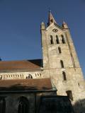 |
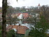
The tower of St John’s Lutheran Church in Cēsis, which is one of the oldest stone buildings in Vidzeme, offers a view of the historical centre of Cēsis, and a wide area all the way to Zilaiskalns Hill. There is also the western tower of the ruins of the Cēsis castle, one of the strongest fortresses of the Livonian Order in the Baltic region, and it offers a grand view of the castle’s park.
|
|
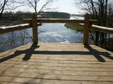 |
The Mežotne castle hill is on the left bank of the Lielupe River and opposite the Mežotne Castle. This was one of the largest Semigalian fortified castle hills during the 9th to the 13th century, and an ancient town alongside the hill covered 13 ha of land. The castle hill has been improved. A pontoon bridge across the Lielupe allows hikers and bikers to reach the castle (between May and October). Vīna Hill is approximately 500 m to the South of the castle hill, and a wooden pathway leads to it. |
|
 |
From the highest point in the Alūksne highlands, you will see an unusually beautiful view of the surrounding forested hillocks and the small areas of meadows and farmland. Sadly, there are no improvements to the location, which can be difficult to access. It is on private property.
|
|
|
|
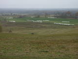
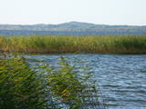
No ūdens tūrisma attīstības centra „Bāka” skatu laukuma, kas atrodas Lubāna ezera ziemeļdaļā pie V 560 autoceļa, paveras viens no labākajiem Lubānas ezera skatiem. Redzams milzīgais Latvijas lielākā ezera klajs un Kvāpānu – Īdeņas zivju dīķu ar dambjiem ainava. |
|
 |
From the Asote castle hill, which is on the right bank of the Daugava River near Jēkabpils, there is a fine view of the Daugava River valley, the Ābeles Island, and the Kaupre castle hill that is at the northern end of the island.
|
|
 |
A beautiful part of the Rēzekne-Dagda-Krāslava road – along two km or so, you can see Lake Rāzna and Mākoņkalns hill, which is 10 km away on the other shore of the lake. |
|
 |
Aptuveni 0,5 km dienvidos no Mežotnes pilskalna atrodas Vīna kalns, kas līdzīgi kā Mežotnes pilskalns, ir veidots, izmantojot Lielupes ielejas stāvās krastu nogāzes, tās pārveidojot. Vietvārds ir it kā radies no stāsta, ka šeit parādījies dievgalds ar maizi un vīnu. Vīna kalnu ar Mežotnes pilskalnu savieno jauka koka laipa, kas ved pa Lielupes ielejas pamatkrasta lejas daļu. |
|
 |
At the Aizkraukle Lutheran church along the upper part of the shores of the ancient Daugava River valley, there is a bit of an old road from which one of the most beautiful views of the central section of the river can be seen, particularly when the trees are bare. Approximately one kilometre to the North-west is the Aizkraukle castle hill, which offers a no less impressive view.
|
|
 |
In Dagda, on the side of Daugavpils Street, there is a forested hillock that is the Lubāne castle hill. On the upper part of its southern side, there’s a viewing area which offers a view of the small Lake Lubenenis, the eastern part of Dagda, and the white tower of the local Catholic church. Legend has it that treasure is buried here.
|
|
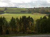 |
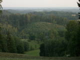
As you travel from Kandava to Sabile, you will find a parking lot on the right side of the road. From there, there are steps to a viewing area on the highest hill in the Abava Ancient River Valley – Greiļi Hill. This offers a wonderful view of the ancient river valley and the local mosaic of meadows and forests. The landscape is enriched by the Imula and Amula valleys that are on the other side of the ancient river valley.
|
|
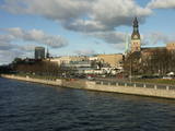 |
The classical skyline of Old Rīga can be enjoyed from several locations – Mūkusalas Street, between the railroad bridge and the stone bridge, from the stone bridge, from the A-B dam, from the grounds of the central office of the Swedbank bank, from the Vanšu bridge, and from the Ballast Dam at Ķīpsala. You can hike or bike from location to location. During the summer, little ships cruise up and down the Daugava to offer different views.
|
|
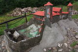 |
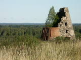
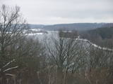
The Naujene castle hill is on the steep bank of the Daugava River, is up to 25 metres high and has two valleys on its sides. Between 1275 and 1277, the master of the Livonian Order, Ernst von Ratzenburg, organised the construction of a brick castle to replace a Lettigalian wooden castle that had stood there before. The castle had a drawbridge and an external and internal forecastle. Until the middle part of the 16th century, the castle was the residence of one of the top officials in Dünaburg. The forces of Ivan the Terrible sacked the castle in 1577, after which the location lost its strategic importance. New fortifications were built in the location that is now the city of Daugavpils. Alongside the ruins of the castle is a miniature model that helps to imagine the appearance of the location many centuries ago. A well-appointed pathway leads from the car park to the castle hill. The hill offers one of the loveliest views of the curvy Daugava River and its surrounding nature park. |
|
 |
The town of Talsi is known as the “town of the nine hillocks,” and it is worth touring the location on foot. You’ll find the best views from the Talsi castle hill (views of Lake Talsi and Ķēniņkalns Hill), Sauleskalns (Lake Talsi, the castle hill, Ķēniņkalns Hill), and the hiking trails of Ķēniņkalns (Lake Talsi, the castle hill, the historical town centre).
|
|
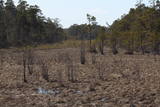 |
The Kurzeme Peninsula has the largest landscape of hillocks and valleys in Europe in the shoreline segment from Melnsils and Kolka to Oviši and Liepene. It is a unique landscape in Latvia, and part of it is in the Slītere National Park. The Pēterezers Nature Trail offers the best chance to look at the landscape. There are hillocks and valleys elsewhere, too – near shoreline villages where the Kukšupe valley (one of the longest ones – 8 km in all) is crossed by the Ventspils-Kolka highway, as well as near Apakšceļš. The only thing is that you need to learn how to spot the areas out in nature. |
|
