
| No | Name | Description |
|---|---|---|
 |
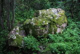
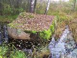
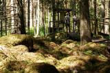
The surface of the rock once contained
text about the destruction of local Livs by Swedish King Charles IX and by the Black
Plague (the rock is on a spot where victims of the plague were buried, and the text
has been erased over the course of time). The smallest rock on the top, which also
used to have an inscription, has been brought here from the Pakalni homestead.
|
|
 |
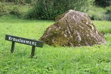
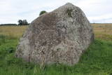
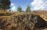
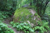
The Stone of Āžmugura is a fawn- coloured triangular prism boulder
which recalls the goat's back.
|
|
 |
Jaunstašuļi Devil's Footstone is situated in the village of Jaunstašuļi in overgrown place beside the
derelict houses. It is hard to find it without the guide. The boulder is 0,75 m high and its circuit is 5,85 m.
On the surface there is the human foot: the length 0,3 m, width 0,09 m, depth 0,02. There was another foot.
It’s obviously scaled off. The North side of the boulder has three casted steps.
|
|
 |
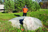
The Boulder of Purmaļi is the biggest boulder in Rēzekne district and one of the 20 biggest boulders in
Latvia. It is located on the escarpment surrounded by the trees and the bushes. Perimeter 18,5 m, height 3,2 m,
lenght 5,6 m, width 4,7, surface volume 30 m3.
|
|
 |
Līdz akmenim aizved (ir norādes) skaista taka, kas līkumo pa Rogāļu strauta izrauto gravu. Strauta kreisā krasta nogāzē, ~ 0,1 km pirms tā ietekas Daugavā, iegūlis 6,5 m garais, 4,6 m platais un līdz 3,7 m augstais Rogāļu akmens, kura tilpums ir novērtēts ap 40 m³. Blakus tam atrodas liela atlūza. |
|
 |
Rīgas – Daugavpils šosejas (A 6) malā (vietā, kur no Zemkopības institūta nogriežas ceļš uz Skrīveriem) redzama zema ieplaka ar Kraukļu akmeni, kas ir sena kulta vieta. Pie akmens veikti arheoloģiskie izrakumi, kuru laikā atrastas senlietas. Vecākā ir no 12. gadsimta. Akmens aprakstīts slavenajā Andreja Upīša (1877. – 1970.) darbā „Sūnu ciema zēni”. |
|
 |
Ļoļi Devil’s Footprint is situated in Mākoņkalns rural territory in a small forest lawn several meters from the
ditch, which is a borderline of the Rēzekne and Krāslava districts. It is about 1,9 m high truncated cone, the base
perimeter 1,8 m. According to the legend, the boulder had a curvy of the horseshoe prints. Now it’s shapeless. For the
first time the stone as a geological monument was established in the 1930s. It was in Andrupene rural territory.
|
|
 |
The great Black Plague rock, which has engraved text that can still be seen
to a certain extent – it tells future generations about the local pastor who died
from the plague, about how the parsonage was established at Sīkrags and then
moved to Mazirbe. The rock is also a monument to six pastors of the nearby
congregations. All the three stones tell about the horrors of the Black Plague in
1710, the texts have been engraved during the parson Peterson in 1711-1734.
|
|
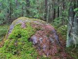 |
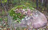
The Grandboulder of Komultēni is situated in Sakstagals rural municipality in the forests; around 700
m from Jēkabpils – Rezekne road to the NE of Komultēni. The flat top and the sides are cracked. Boulder consists
of the magmatized gneiss. The circuit of the boulder is 15 m, length 5 m, width 3 m, height 1.8 m,
capacity about 20 m3.
|
|
 |
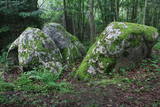
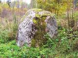
Platais Boulder (Wide boulder). You can find it in the rural municipality of Mākoņkalns not far from a
small meadow close to the boulder of Āžmugura. Both the boulders have their legends. Some say that the
boulder of Āžmugura is the part of Platais boulder and the rainwater from its cavity heals the warts.
|
|
 |
Atrodas 4,5 km ziemeļos no Rīgas – Daugavpils šosejas (A 6), klajā laukā (ap 3 m augsts, ainavisks). Viens no izcilākajiem Latvijas muldakmeņiem, tādēļ ir vērts izmest kādu loku. Akmens augšdaļā ir iekalts gandrīz 2 m garš un ~ 20 cm dziļš muldveida iedobums. Atrodamas ziņas, ka vēl 19. gs. vidū pie akmens ir ziedots ēdiens, monētas u.c. priekšmeti. Pie tā dedzināti ugunskuri un svinēti svētki. Teikas vēsta, ka velns muldā lējis ūdeni un gribējis mīcīt mīklu, kā arī parāvis zem akmens tuvējo māju saimnieku. |
|
 |
Ziemeļos no Viļāniem (Jaunviļānos) atrodas ar mežu apaudzis osveidīgs paugurs – t.s. Kaupra kalns, kurā virsotnē meklējams (ceļa uz Trūpiem malā izvietota norāde) minētais akmens. Trīsdaļīgā akmens, kas atrodas mežā, garums ir 4 m, platums 3 m, augstums 1,9 m. Lielākās daļas virspusē var saskatīt nelielu dobumu, tādēļ pastāv viedoklis, ka šis ir sens kultakmens. |
|
 |
Ja Rušona ezeru iepazīstiet ar laivu, tad var apmeklēt Lielo salu (ezera rietumdaļā),kur (augstākajā vietā) ir jāuzmeklē ap 1,2 m augstais akmens. Konstatēts, ka tā apkārtnē un uz virsmas kurināta uguns. Atrastas arī senlietas. Nostāsti vēsta, ka akmens virsmā bijušas iekaltas zīmes (nav saskatāmas) un pie tā upurēti jēri. Tikai nedodieties ezerā, ja ir vai gaidāms stiprs vējš! Rušona ezera salas ir dabas liegums. |
|
 |
The rock is along the main street of Krāslava and is found at Augusta Street 12. After major reconstruction of the city’s infrastructure, the rock was successfully integrated into the surrounding landscape. The rock is 2.8 m long, 2.2 m wide and 700 cm high. It once served as a border stone for the village of Krāslava. It was placed there in 1729 to commemorate the day when the noble Plater dynasty bought Krāslava. The dynasty’s seal is engraved in the side of the rock along with the date when it was installed. Legend has it that Polish King Augustus II dined at the rock after a hunt, and that is why it is known as Augustus’ Rock. |
|
 |
Horse's Footstone has a curvy that recalls a horse's footprint.
|
|
 |
The Devil Stone of Ubagova (Čorta kameņs). The cult place is situated in the Southern side of the
village Ubagova 30m to the N NW from the cemetery of the village. According to the legend, there are
ghosts so you shouldn’t walk there alone because they can trap you in the woods. The boulder is about 1.6
m high. The surface is smooth, without any cuts.
|
|
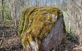 |
The Boulder of Labvārži is located in the Northern side of Adamova Nature Park, in the SW of Lake
Vizulītis (Labvārži). It is located 0,70 km from the Labvārži or Laboržu House. The boulder is 5.9m long and
4,0 m wide.
|
|
 |
The forest around Kaltene features a natural miracle – the rocks of Kaltene, which are also known as the barrier rocks. The rocks are 2-3 m from the sea and date back to the Ice Age. The Devil’s rock is the largest one. It used to be a beautiful pile of rocks that “stretched to the tops of the trees.” In older maps it is described as being 20 m high. It had many natural rocks, including some that were completely round, while others resembled plates. The rock was almost completely destroyed in the 1960s and 1970s, when it was chopped up to build roads. A fairly small part of the rock survives today, and it is 300 m long and 2 m high. Scientists believe that these rocks used to be sacred locations, because there are many legends and stories about them. There is a forest path with wooden pathways, information stands and a small car park there. (Source: Roja TIC) |
|
 |
200 m attālumā no Gulbenes – Madonas ceļa mežainā nogāzē iegūlis 2,4 m augstais akmens. Tā lēzenajā virsmā iekalta ap metru gara, 0,3 m plata un ap 4 cm dziļa iedobe, bet akmens šķautnē - pakāpieni. Uzskata, ka šis ir sens kultakmens, pie kura ziedots. Lai nokļūtu līdz akmenim, vasaras otrajā pusē var nākties brist pa garu zāli. |
|
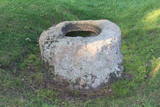 |
The Pinnu (Dievekļa) Sacrificial Stone is at Ulmale, some 300 m from the Liepāja-Ventspils highway (there are signs). This is a very beautiful and distinct bowl-type rock, and the indentation at the top is 15 cm deep and up to 61 cm in diameter. It is thought that this was an ancient cult location, particularly between the 16th and 18th centuries. |
|
