
| No | Name | Description |
|---|---|---|
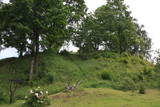 |
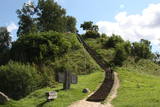
Atrodas 0,3 km ziemeļos no Vecpiebalgas pilsdrupām. Ap 10 m augsto, bet visnotaļ izteiksmīgo Grišku kalnu sauc arī par Piebalgas, Balgas un Veļķu pilskalnu. 13. gs. šeit bijusi svarīga apmetnes vieta ar mākslīgi nostāvinātām nogāzēm un dziļu aizsarggrāvi. Vēstures notikumi ir atstājuši ap metru biezu kultūrslāni. Bezlapu laikā no kalna paveras skats uz Vecpiebalgas baznīcu un pilsdrupu vietu. Pilskalna piekājē ir aka ar Griškavotu. |
|
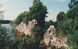 |
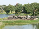
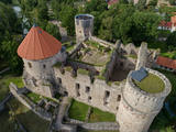
The castle hill is an island in the reservoir of the Pļaviņas hydroelectric power plant, and it can be accessed by boat. The ancient Selonian castle hill was settled several times between the 6th and the 12th century. This was the political and military centre of the Selonian region. In 1373, the Livonian Order built a stone castle on the hill, as it did on many other ancient hillocks. The castle was sacked in 1704 during the Great Northern War. Remnants of a square tower, a guard room and the 12 m embankment that once protected the castle are all that survive. Approximately 300 m to the North of the Sēlpils castle hill is Oliņkalns hill, which is underwater. |
|
 |
To the East of the Ezermuiža-Dūmele road you will find the bed of the ancient Lake Dieviņezers. It was one of the largest lakes in Kurzeme in the past, being 7.5 km long and 1.6 km wide. A canal was dug in 1838 (Melnsilupe River today), and the water from the lake was siphoned to the sea so as to create fertile farmland. Residents of Ezermuiža have been involved in forestry work since the age when barons ruled the land. Dūmele is connected to Košrags by a lonely forest road that is known as the Bottom Road. A bike route runs down it. The Ziedkalni weekend house is in Dūmele. The "Ziedkalni" homestead in Dūmele offers spa services, cod fishing and accommodations. |
|
 |
The Strūves Park is toward the northwest of Jēkabpils, on the left bank of the Daugava, and opposite the Ādamsona (Krustpils) island. The park was established in the 19th century as a place where the city’s residents could relax and hold celebrations. It can be said with absolute certainty that this is a place of global importance, because the park contains a memorial stone to Professor Friedrich Georg Wilhelm Struwe (1793-1864) from the University of Tartu. He was an astronomer and geodesist. The stone is at a place where Struwe completed his land survey of the Vidzeme Province of the Russian Empire. The meridian location which Struwe identified (and other points related to those locations are found in many other European countries) is on the UNESCO list of world heritage. |
|
 |
Šis ir viens no retajiem ceļiem, kurš saglabājies kā notikumu liecinieks. Ceļš ved no Krimuldas uz Siguldu. Jau vācbaltu apgaismotāja novadpētnieka – mākslinieka Johana Kristofa Broces 1794. gada zīmējumā "Siguldas un Krimuldas pilsdrupas" redzams lauku ceļš gar Krimuldas pili, pa kuru iet zemnieks un darba ratus velk zirgs. Lai braukšana pa Gaujas senlejas nogāzi ar zirga pajūgu būtu droša, ceļu izveidoja līkloča formā, tā uzbrauktuvi padarot daudz lēzenāku. Domājams, ka ceļš atjaunots 19 gs., kad Krievijas cars Aleksandrs otrais un viņa sieva ieradušies uz vizīti siguldā. Pāri ceļam bijuši vairāki mazi tiltiņi, ko iedzīvotāji dēvējuši par velna tiltiem. Tagad serpentīna ceļš kļuvis par romantisku pastaigu vietu. |
|
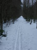 |
One of the most interesting objects in Bigauņciems, the road begins at the seashore, crosses the Vecslocene River (there is no bridge, but hikers and bikers can get across it), and then continues as a forest road to Lake Melnezers. |
|
 |
The Lake Castle of Āraiši is of pan-European importance. It is a reconstructed Lettigalian lake castle from the 9th or 10th century, and it is the only place in the Baltic States at which visitors can learn about how people lived more than 1,000 years ago. The castle offers various thematic events. |
|
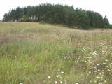 |
This partly forested hillock stands 40 metres above the surrounding area and offers impressive views. The fact that this was once a castle hill is attested by the presence of a moat and remnants of defensive fortifications. It is thought that Lettigalian tribes settled here in the 10th century AD. You can climb the hillock to take a look at the surrounding landscapes. |
|
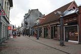 |
Pirmā Liepājas gājēju iela. 140 m garā iela par gājējiem piemērotu tika pārveidota mūzikas festivāla “Mēs Liepājai” (1988. g.) laikā savāktajiem līdzekļiem. Daudzo veikalu un kafejnīcu dēļ iela ir dzīva, tāpēc vietējo iedzīvotāju un viesu iecienīta. |
|
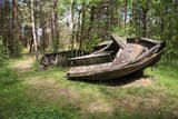 |
In the 1960s, the Soviet Union banned individual fishing in the sea, and the motor boats which had no other purpose were simply beached in the dunes. It is said that members of the Border Guard often set the boats on fire. Another story is that the Border Guard banned an ancient tradition of burning old boats on Summer solstice Eve. Along the road to the cemetery is the old net barn, which is a residential building today. |
|
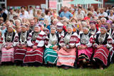 |
Setomaa in South-East Estonia is a unique area for its people (the Seto) and culture. The historic location in the borderland between East and West, straddling two languages and cultures has shaped the local language, life style, clothes and food. A very specific type of singing – leelo – is incorporated in the UNESCO list of Masterpieces of the Oral and Intangible Heritage of Humanity. |
|
 |
Eine der größten befestigten Siedlungen im Bezirk Harju, befindert sich auf einer Erhebung des natürlichen Kliffs Nordestlands. |
|
 |
Cesis Castle complex is a place where the past meets the future. |
|
 |
The site of the Oak tree of love, which was
once a symbol of the growth of Ķemeri on the
left bank of the Vēršupīte.
|
|
 |
Vijciema čiekurkalte savu darbību uzsāka 1895. g. pēc plašiem apkārtnes meža ugunsgrēkiem. Šobrīd tā ir vecākā Latvijā un viena no vecākajām Eiropas čiekuru kaltēm. Pēc ceturtdaļgadsimta dīkstāves to atjaunoja 1992. g. Vienreizējais kultūrvēstures piemineklis ir saglabāts pilnīgā darba kārtībā. Ēkā atrodas 19. gs. beigās ražotā autentiskā iekārta un aprīkojums. Arī mūsdienās to izmanto čiekuru žāvēšanai. Ekskursijas laikā apmeklētāji var iepazīties pilnu čiekuru (g.k. – priedes) apstrādes ciklu. Ziemā, kad ir īstais čiekuru žāvēšanas laiks, te demonstrē kaltēšanas procesu. Vijciema čiekurkalte ir iekļauta Eiropas kultūras mantojuma objektu sarakstā. |
|
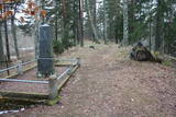 |
The Middle Ages and the beginning of the last century cemetery at the church of Mazirbe. It is surrounded by a moss-covered stone fence. There you can find a number of interesting sights-Werewolf's Tomb, Old Taizelis Tomb, Grand Pine, etc.. |
|
 |
Eine der ältesten Ortschaften Litauens. Schon im 14. Jh befand sich hier eine Holzburg. Der 20 m hohe Merķine-Burgberg an der Mündung der Flüsse Merkys und Nemunas. |
|
 |
Die Straße führt durch die ehemaligen Fischerdörfer. Eine bessere Radfahr-Alternative auf der Strecke zwischen Häädemeeste und Ainaži. |
|
 |
Svētkalnā atradusies krustnešu nocietinātā pils. Zemgaļiem to nebija pa spēkam ieņemt, tādēļ, nodedzinādami savu pili Tērvetes pilskalnā (1286. g.), tie aizgāja uz Raktes (Žagares) novadu Lietuvā. Kad Svētkalna nocietinājumi bija zaudējusi savu militāro nozīmi, krustneši to nojauca. 1701. g. Ziemeļu kara laikā Svētkalnā atradās zviedru armijas nocietinātā apmetne, no kā arī cēlies vietvārds. Domājams, ka pirms tam šajā vietā atradusies seno zemgaļu svētvieta. No Svētkalna paveras viena no skaistākajām un biežāk fotografētajām Tērvetes ainavām. |
|
 |
A straight street which runs through Ķemeri in the northwestern-southeastern direction. The street's name is a proof that it is the former historical boundary between the regions of Vidzeme and Kurzeme. Near the intersection of Robežu and Tukuma streets, you can notice the former pharmacy building-the memory of the former resort of the all-union significance. On the walls there has survived the pharmacy-related symbolism. |
|
