
| No | Name | Description |
|---|---|---|
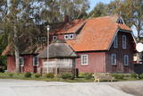 |
Ein ehemaliges Fischerdorf am Ufer des Kurischen Haffs. Aufgrund der Wanderdünen hat seinen Standort mehrmals seit dem Anfang des 19.Jh. geändert. Holzbebauung mit einheitlichem Stil und Traditionen. |
|
 |
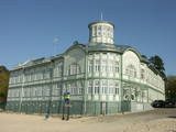
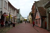
Die zentrale und auch schönste Straße in Trakai mit bunten Holzhäusern. Eins der seltenen Kenesa-Gebetshäuser der Welt – ein eingeschossiges Holzhaus mit einem bläulichen Dach. |
|
 |
Although out of 104 village houses 97 were destroyed during World War I, at the end of the 30ies of the 20th century Lapmezciems "recovered" fast, and one of the most powerful coastal fishermen cooperatives in Latvia were operating in it. During the Soviet times here one of the largest fishery collective farms – "Selga" was founded here, the blocks of which can be seen at the mouth of the Siliņupe River. Today Lapmezciems is a popular area for summer cottages, a recreation and bathing place. As an interesting history monument of fishery the sedum of Lapmezciems is available for viewing – it is the former wharf of fishing boats, where fishermen built nest cabins and stored their equipment. Between Pīlādži Street and the left bank of the Siliņupe River in the 3rd and 2nd millennium BC settlement of fishermen and hunters were located, where a memorial stone is erected. This is the most ancient known location populated by humans within the territory of Kemeri National Park. Part of the findings is displayed at Lapmezciems museum, where local history research exposition is formed and materials about Finnish Jeager fights within the territory of Klapkalnciems are gathered. |
|
 |
Ein einzigartiges Örtchen beiderseits des Flusses Minija, wo der Fluss eine „Hauptstraße” ist. Litauens Venedig. |
|
 |
On the way to Turaida you must definitely stop at Gutmana cave. It is the widest (12 m) high (10 m) and in terms of volume - one of the biggest Latvian caves (cave like niche), which is also an important cultural and historical site, place rich with stories (most popular of Turaida Rose), surrounded by ancient walls and ceiling inscriptions (oldest from the end of 17th century). A spring originates from the cave; it is believed that it has healing properties. Turaida Museum reserve with Batlic scale outstanding monuments whose history stretches over 1000 years in the distant past is located at the point where the right mainland of Gauja valley is split by deep ravines of several small streams. Their exploration can be started with Turaida manor (first mentioned in 16th century), which is an outstanding example of Vidzeme manors. 21 buildings, built between the 18th century until the beginning 20th century are preserved until now. Visitors can see the manor stables, coach house, sauna, forge, fish cellar, barn, foreman house, the old residential buildings of landlord, and residential building of manor servants, oust house, etc. While walking in Turaida direction, we will reach the grave of Turaida Rose, which relates with the legend of Turaida Maija, who sacrificed her life for love. Near the grave grows a great linden tree (poor condition), wich is believed to be planted on the grave of Maija. Turaida Lutheran Church that lies further is the third church in a row and one of the oldest (1750) Latvian wooden churches – single volume wood log building with a baroque tower. Here you can see the altar and pulpit (Middle of the 18th century), altarpiece "Golgotha" (end of the 17th century – beginning of the 18th century) and historical exposition. Tautasdziesmu (folksongs) Park stretches at the Dainu Hill, the development of which started in 1985, noting the 150th anniversary of father of Latvian folk songs – Krisjanis Barons. More than 26 stone sculptures created by the sculptor I. Ranka are exhibited here. This is also a place of annual folklore events. Before the construction of Turaida stone castle (started in 1214), wooden Liv castle stood here. Turaida castle belonged to the Bishop. It existed for a long time - until to the 1776 when it was burned down. In 1953 an extensive restoration works was started here; upper storey of main tower, barn building (exposition on Sigulda district), semi-circular tower and castle complex in the southern enclosure was restored. Now the museum exhibition is established at the castle premises, which tells about the historical events in the surroundings. |
|
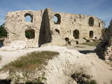 |
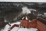
The ruins of the Koknese Castle are found where the Daugava and Pērse rivers flow together. The castle, which is on a floodplain, was built for the bishopric of Rīga in 1209, and it replaced an ancient Latvian castle that was made of wood. The castle was blown up by Saxon forces in 1701. A visitors centre is near the ruins, and there you can carve a Medieval coin or rent a boat to sail down the Daugava. Make sure to stroll through the Koknese park, which is alongside the ruins. |
|
|
|
Vom 18. Jh wurde die Stadt ein russischer Marinestützpunkt. Von 1962 bis 1994 war Paldiski ein Übungszentrum für atomare U-Boote der Sowjetischen Marine mit zwei auf dem Festland befindlichen Kernreaktoren (ung. 16.000 Beschäftigte) und eine "geschlossene Stadt". |
|
 |
Third biggest island in Estonia. Full of beautiful grown junipers, little dolomite outcrop on the coast of the sea and fishermen villages on the coastline. |
|
|
|
The town of Subate was first listed in documents in 1570, when Duke Gotthard Kettler of the Duchy of Courland sold the Subāte marketplace to Count G. Plater-Sieberg. When the Plater-Sieberg dynasty converted to Catholicism in the mid-17th century, Lutherans in Subate protested by moving to the eastern bank of Lake Subate. That was the property of the Prode Estate (only ruins remain at this time), which was owned by the Osten-Sacken dynasty. In 1685, the Osten-Sackens built a Lutheran church for the “refugees,” and Jaunsubate was established around it. Both parts of the town were merged again in 1894. During Latvia’s liberation battles in 1919, Subate was liberated by Lithuanians, at which time the town was divided up between Latvia and Lithuania (though the border between the two countries was set at the previous line in 1921). The historical centre of Subate was established between the 16th and the 19th century, and it includes four churches for various congregations and low wooden buildings which stretch along narrow and curvy streets. The town is on the shores of a sub-glacial depression with Great Lake Subate and Lesser Lake Subate therein. This provides the town with unusual landscapes for Latvia. |
|
 |
Plavinas and Stukmani region was inhabited already in the third century. During the Polish-Swedish War (1600-1629) at estuary of Aivekste in the Daugava River the Swedish war camp was formed, from which are preserved fortifications - bastions. They are one of the most impressive military formations of this kind in Latvia. Plavinas as a larger populated area started to develop in the nineties of the 19th century and in the beginning of 20th century after the construction of railway. Today Plavinas are more commonly known with dolomite production sites and spring flood area. |
|
 |
Jaunpils development is linked to the Livonian Order's castle, which until now has hardly changed its building volume and appearance. From 1561 until 1919 it belonged to the barons Reki family. In 1905 the castle was burned down, but later it was reconstructed under the supervision of architect V. Bockslaff. Substantial castle restoration work began during the sixties of 20th century. Now in the castle is a museum, but gourmets can taste medieval dishes at the castle tavern. |
|
 |
Jurmala town (the second largest in Latvia) was founded in 1959, by combining Kemeri and Sloka towns in the Riga city Jurmala district. It stretches 32 km along the coastal line of Gulf of Riga. Jurmala resort once was one of the most important objects of this type in the Northern Europe. This was facilitated by the development of local and interstate transport and traffic (coaches, steamers, train). The first guests was accommodated in Dubulti, where in 1834 the first hotel was built, but in 1847 - The first wellness centre. In the 19th the first medical institution launched. Starting from 1834 the rapid construction of summer cottages began. Development of the resort was ended by the World War I. After the war the number of resort vacationers boomed from 12 thousand (in 1920) to 32 thousand (in 1935). Kemeri resort developed along with Jurmala, which received a massive of vacationers' amount during the Soviet period. |
|
 |
Known as Alšvanga in the past, this place was mentioned for the first time in 1231 in an agreement that was signed between the deputy legate of the pope in Rome and the Courlandian tribes of the region. The Livonian Order ruled the territory until 1561, and from 1573 until 1738 the order’s castle belonged to the von Schwerin dynasty from Pomerania. It during the rule of this aristocratic family that a stone church was built in honour of Archangel Michael, and local residents began to convert to Catholicism. Alsunga became the Catholic centre for all of Kurzeme, and local residents became known as the Suiti (from the Schwerin suite). For nearly 400 years, Alsunga has been the historical centre of the Suiti territory. This is Latvia’s most conservative region and is widely known with unusual songs, colourful folk costumes and various folk traditions and beliefs. The Suiti have their own dialect, foods and many other things that have been long since abandoned or forgotten elsewhere in Latvia. The religious has commingled with the folk here in one unique whole. The Alsunga District covers 191 km2 and has some 1,500 residents. |
|
 |
This is an ancient populated area. There were 50 homesteads here during the 1930s, with only ten remaining in 1990. The Livonian scholar and entomologist Kārlis Princis (1893-1978) was born in Oviši. In 1944, he emigrated to Sweden. The Oviši lighthouse (1814) is 38 metres high and is the oldest functioning lighthouse in Latvia. There are lovely views from the top of the lighthouse. The building in which employees of the lighthouse used to live was erected in 1905 and has been preserved. A narrow-gauge train station was in the building at one time. The Oviši Lighthouse Museum is nearby, as is the metal Tree of Austra. Opposite Cape Oviši is a great place for bird watching. |
|
 |
To the south of Koknese, the Destiny Garden is on an island that is surrounded by the waters of the Pļaviņas hydroelectric power plant (there is a bridge to the shore). The aim of this fundamental open-air object was to commemorate people in Latvia who suffered because of totalitarian regimes. The first work here began in 2008, and the designer of the landscape was a Japanese landscape architect, Shunmyo Masuno. Work on the garden continues, but it is already a popular tourist destination. The first permanent structure is a terrace that offers a view of the Koknese castle ruins and the local Lutheran church. This means that there will be something new each time that people visit the park. People are invited to bring rocks for this nationally important location that commemorates Latvia’s history. |
|
 |
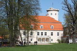
Construction of the Sigulda castle was begun by the Order of Brethren of Swords in 1207, but in 1236 it was rebuilt for the needs of the Livonian Order. The building suffered much damage during wars in the latter half of the 16th century and the early part of the 17th century. It was burned down during the Great Northern War and was not restored. Visible today is the south-western wing of the castle’s convent building and the main gate tower, behind which is the internal forecastle with an open-air stage that offers an impressive view of the ancient Gauja River valley. The new Sigulda castle was built between 1878 and 1881, and it was owned by Count Kropotkin. From 1923 until 1940, the castle housed a centre for writers, and during the Soviet Union it was a hospital for cardiology patients. Since 2003, the Sigulda Administrative District Council has been located here. The buildings that have been preserved include a wooden home (mid-19th century), where the Kropotkin family used to live, a granary (late 18th or early 19th century), the home of the gardener (19th century) and a brick wall (19th century). If we go to the north-eastern direction, we will find the Vējupīte valley less than two kilometres away. It includes the shallow (3.6 m) but high (6.1 m) Pēteris cave and the deep Pūču valley with the little Kraukļupīte River. At the place where the two valleys come together we find the Satezele castle hill (its flat surface is 90 x 75 m), where, in the early 13th century, the oak castle of the ruler of Livonian lands, Dabrelis, was once found. Nearby is the Kraukļu valley, with 11 m sandstone walls and a cave that is 5.2 m deep. Nearby is the Paradise (Painter) hill, which offers a lovely landscape that has been painted and photographed since ancient times. There is a Ferris wheel in the western part of Sigulda that is open during the summer, as well as an aerial tram that is the only transport vehicle of its type in the Baltic States and was installed in 1969. The cable that carries the tram is 1,060 metres long and links the shores of the ancient Gauja River valley between Sigulda and Krimulda. The cable is approximately 40 metres above the Gauja. The south-western part of Sigulda features the mighty Beite cliff which is split by a deep stream valley. To the west of the cliff is the Emperor’s View viewing area that is 67 m above the Gauja and offers a good view of Krimulda and the Turaida Castle. A viewing area was established here in 1862, when Tsar Alexander II of Russia visited Sigulda. The wooden Emperor’s chair is to the east of the viewing area. The Turaida Museum Reserve is in the place where the shore is split by deep valleys carved out by streams. It features several outstanding monuments that are as much as 1,000 years old. Of note are the Turaida Estate (21 buildings), the grave of the Rose of Turaida, the Turaida Lutheran Church (1750), which is one of the oldest wooden churches in Latvia) and the Turaida Castle. Folksong hill, which is nearby, is used for various thematic events. |
|
 |
The history of Cēsis begins at the Riekstu hill, which is 18 m high and the surrounding area. There was a wooden castle built by the Vendian tribe that stood there from the 11th to the 13th century. The hill is in the central part of the castle’s park, and it offers a fine view of the park, a pond and the ruins of the Cēsis Castle. A long staircase leads to the hill. The Cēsis Castle was built in the early 13th century as the residence of masters of the Livonian Order, and it was one of the most fortified forts in the Baltic region. Alongside is the New Cēsis Castle, which was built in 1777 in a place where gate fortifications had been before. The building houses the Cēsis Museum of History and Art, and an annex contains the Castle Visitor Centre and the Cēsis Tourism Information Centre. From the tower of the castle, we get a good view of the castle ruins, St John’s Lutheran Church and the northern stretches of the city. Opposite the new castle is the stable of the Cēsis Castle Estate and a wheelhouse (both from the first half of the 19th century). Today these house the Cēsis Exhibition Hall. Other buildings include a granary, a hut for coachmen and an old brewery. On the other side of the street is the romantic May park, which was installed during the 1830s. Streets in Cēsis include Lielā Katrīna, Mazā Katrīna, Mazā Kalēju, Kalēju and Lielā Līvu streets and Līvu square with wooden buildings from the late 18th and early 19th century. Torņa Street stretches along the walls of the Medieval castle. Outside the church is a sculpture, “As the Centuries Pass By,” and legend has it that anyone who rubs the lantern of the Old Time Man can see the future. One of the most impressive buildings in Cēsis is St John’s Lutheran Church, which was built in the late 13th century by the Livonian Order. The Roman-style three-segment basilica has elements of Gothic design and a 65 m steeple that was installed in 1853. The building was reconstructed several times during the 20th century and contains grave plaques relates to masters of the Livonian Order and local bishops. The pulpit dates back to 1748, the oak altar was manufactured in 1858, and the altar painting “Crucified One” was painted in 1862. The windows of the altar part of the church contain artistically valuable stained glass. The organ was manufactured in 1907 by the E.F. Walker firm, and it is one of the best concert organs in Latvia. The solar clock with the number 1744 is in the south-wester corner of the church. It is worth scaling the viewing tower of the church. At its foot is Rose Square, which was a market square from the mid-13th century until 1927 and was restored in 2008. This is the central square in the city. During the Middle Ages, a punishment pole and the city well were here. Rīgas Street has been the main street in the old part of the city from the very start, and here we find most of the architecturally distinguished buildings from the 18th and 19th century – the former city hall, the Fābers house and the Princess house. At one end of the street is Liv Square, where there a church, cemetery and the Rīga gate in the city’s walls existed in the 13th century. Today the square is decorated by a lighted fountain at a place where a well was found in the 13th century. On the other end of the street we find a reconstruction of the foundations of the Rauna gate from the 14th and 15th century, offering a good look at Medieval walls and the size and strength of the gates. It is commonly claimed that the national flag of Latvia was born in Cēsis, but it must be emphasised that the flag that is mentioned in chronicles was designed in Cēsis in 1279 as the ideological prototype of the current Latvian flag, while the story of the first national flag actually comes from Valmiera, where it was sewn in 1916. |
|
 |
Ja mērķis ir savākt pilnvērtīgu etnogrāfisko ciemu fotokolekciju, ir jāapskata Strazdi (no lietuviešu valodas strazdai tulkojumā nozīmē strazds), kas ir pavisam neliela apdzīvota vieta Balošas (Baluošas) ezera ziemeļu krastā. Strazdi pirmoreiz rakstos minēti 1783. g. un ciema nosaukums cēlies no kādas mežziņu dzimtas uzvārda. |
|
 |
Most popular Estonian resort with wide range of leisures and SPA offers. One of the rare Estonian sandy beaches. The Old Town has the main walker street - Rüütli tee. |
|
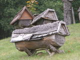 |
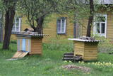
Das bekannteste Museum der Geschichte der Bienenzucht Litauens mit den Bienenhäusern verschidener Arte, der Arbeitsmittel der Bienenzüchter, Holzskulpturen und Hönigankauf. |
|
