
| No | Name | Description |
|---|---|---|
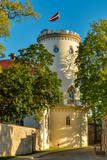 |
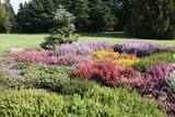
Cēsis is in the centre of the Gauja National Park, but it is not part of the park as such. There are many interesting places in Cēsis to visit and examine. The oldest part of the town is of key interest. The origins of Cēsis can be found at Riekstu hill, which is 18 metres high. Between the 11th and 13th century, there was a wooden castle here built by the Vendians. The hill is in the central part of the castle park, and it offers a good view of the park, pond and the ruins of the Cēsis castle, which can be accessed via a long cascade of stairs. The Cēsis castle (see below) was built in the early 13th century as a residence for masters of the Livonian Order, and it was one of the strongest fortresses in the Baltic territories. Alongside it is the New Cēsis castle, which was built in 1777 where the gate fortifications once stood. The Cēsis Museum of History and Art is in the building, alongside which is a visitors centre and the Cēsis Tourism Information Centre. From the tower of the castle, there is a fine view of the castle ruins, St John's Lutheran church and the northern part of the town. Opposite the New Cēsis castle are stables and a wheelhouse (both from the first half of the 19th century). The Cēsis Exhibition Hall is there today. You can look at the exteriors of the granary, the hut for coachmen, and the old brewery. On the other side of the street is the romantic Maija park, which was installed in the 1830s. The park is popular among parents with children, because there is a playground there. From this area, you can walk down some of the old streets of the town – Lielās Katrīnas, Mazās Katrīnas, Mazā Kalēju, Kalēju and Lielā Līvu streets, plus Līvu Square. The wooden buildings along the streets date back to the late 18th and early 19th century. Torņa Street, which weaves its way along the defensive walls of the Medieval castle, offers a look outside the church of a sculpture by Matiass Jansons, "As the Centuries Pass". Legend says that if you rub the lantern carred by the Old Man of Time, you can see the future. One of the most impressive buildings in Cēsis is St John's Lutheran Church, which was built in the late 13th century for the Livonian Order. It is a basilica built in the Roman style and with Gothic elements. The tower, which is 65 m high, was built in 1853. The building was reconstructed several times during the 20th century. Inside the building are grave epitaphs for masters of the Livonian Order and for bishops. The pulpit was installed in 1748, the oak altar followed in 1858, and the altar painting "The Crucified One" dates back to 1862. The stained glass windows around the altar are of great artistic value. The organ was built in 1907 by the E.F. Walker Company, and the instrument is one of the best concert organs in Latvia. A sun clock featuring the year 1744 is at the south-western corner of the church. It is worth climbing the church's tower. At the foot of the building is Rose Square, which began as a market square in the mid-19th century, remained in place until 1927, and was restored in 2008. This is the central square in the town today. During the Medieval Era, there were stockades here, along with the city's well. Rīgas Street has been the main street of the old town from the very beginning, and it is here that you will find the most architecturally outstanding buildings in town from the 18th and 19th centuries. They include the former Cēsis City Hall, the Fābers building, and the Princess building. At one end of the street is Līvu Square, where, during the 13th century, there was a church, a cemetery and a gate in the town walls. Today the square features a lighted fountain which is on the site of a 13th century well known as Lejas Šķimbēgs. At the other end of the street is a reconstruction of the foundations and surface elements of the Rauna gate that was a part of the town walls in the 14th and 15th centuries. The site offers a good idea about Medieval fortifications and the size and mightiness of gates therein. |
|
 |
Vom 18. Jh wurde die Stadt ein russischer Marinestützpunkt. Von 1962 bis 1994 war Paldiski ein Übungszentrum für atomare U-Boote der Sowjetischen Marine mit zwei auf dem Festland befindlichen Kernreaktoren (ung. 16.000 Beschäftigte) und eine "geschlossene Stadt". |
|
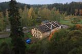 |
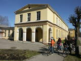
The history of Līgatne cannot be separated from the paper factory which was once the only factory of its kind in Latvia. Tours are available in the company of a guide. During the late 19th and early 20th century, the company built homes, a school, a birthing centre, a hospital, a club, a guesthouse and other buildings for its employees, and most of these buildings have survived to this day. There are more than 200 interesting underground passageways which are still used as warehouses for various items, including vegetables. |
|
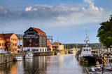 |
The former Memele. The only port city with a old town in Lithuania. |
|
|
|
Neliela apdzīvota vieta, kuras apkārtnē jau izsenis iegūta kūdra un ārstniecības dūņas, kas izmantotas Ķemeru kūrortā. Kūdrā atrodas padomju laikā celtā dzelzsbetona rūpnīca, kura nodrošināja ar būvniecības materiāliem tagadējo Kauguru mikrorajonu.
|
|
 |
Jaunciems has always been a small village, and only a few homes are populated today. Nearby there are leisure locations on the right bank of the Irbe River. Jaunciems is linked to Sīkrags by the former tracks of the narrow-gauge train. There is also a bridge for hikers and bicyclists. |
|
 |
Palanga is known to be the biggest by-the-sea resort in Lithuania because of its seacoast's main attractions - dunes and white sand. And because Palanga is a resort there are plenty of cafes, restaurants, bars and more for those who would like to enjoy a meal or a drink, for those who like active sport - there is possibility to cycle, go horseback riding, swim and much more. |
|
 |
This location is important in terms of Latvia’s history, because during the 12th and 13th century, this was the administrative and spiritual centre of the Lettigalian tribe, with the ruler of Jersika being Visvaldis. The castle stood on the shore of the Daugava at a height of 18 m, and this was a mighty castle hill. The flat part of the hill measured 100 x 75 m, and it was surrounded by a barrier and a defensive wall made of logs. People entered the castle via guarded gates beyond which there were residential and household buildings, as well as a small church. Archaeologists have found the remnants of log buildings, as well as many antiquities from the 10th to the 13th century that speak to extensive trade relations with other parts of Europe, including ancient Russia. In 1209, the forces of Bishop Albert fooled the people in the castle and sacked it and the ancient town that was around it. Visvaldis’ family was taken hostage, and so the Lettigalian ruler was forced to become a vassal of the bishop. The castle hill is privately owned, so please contact the owner before planning a visit. |
|
 |
Renda is a very old town, first mentioned in historical sources in 1230. During the 13th century, Renda was one of the centres of the ancient Courlandian land of Vanema. When Courland was split up in 1235, Renda was taken over by the German Order, and local residents were forcibly drafted into its military. During the age of the Duchy of Courland (1562-1795), the region flourished despite wars, the bubonic plague and other problems, particularly during the rule of Duke Jacob (1642-1682). During the 17th century, Renda became something of a manufacturing centre, churning out timber products, with local lime kilns, watermills, flax weaving facilities, a glass factory and a boiling house for saltpetre and soap. Wine, perfumes and barrels were produced in Renda, as was cast iron for nails and many other things. The court at the Jelgava Castle loved the sour wines from Renda. All of this was destroyed during the Great Northern War (1700-1721). During the 19th century, a chemicals factory was built on the site of the burned Renda castle, and nearby was one of the largest leather tanning plants in Kurzeme, along with a manufacturing facility for turpentine. Cultural life began to develop in parallel to this. Renda suffered much during the two world wars and the subsequent Soviet repressions. The so-called Courelian Battalion of partisans went into the forests after the occupation to continue their struggle against the Soviet regime. Renda today is a small and quiet village with the Lielrenda Estate, a local church, the “devil’s boat” at the Abava River, and the Īvande waterfalls. |
|
 |
Maza apdzīvota vieta ar dažām viensētām uz pussalas (salos tulkojumā no lietuviešu valodas nozīmē „sala") starp vairākiem ezeriem. Salos II ir viens no sešiem Augštaitijas nacionālā parka etnogrāfiskajiem ciemiem. Ciems patiks tiem, kas meklē ļoti nomaļas vietas ar vecām guļbaļķu dzīvojamām un saimniecības ēkām. No Salos II pa sauszemes maršrutu var doties pārgājienā līdz Ladakalnim un Ginuču pilskalnam (sk. iepriekš). |
|
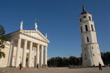 |
The Capital of Lithuania. One of the biggest East Europe's old towns (included in UNESCO World's Cultural Heritage list) where there is a lot of representation of various architecture styles like Classicism, Baroque, Gothique, etc. |
|
 |
Kemeri (Kemmer) are mentioned in the literature sources for the first time in 1561. In the second half of the 18th century and in the beginning of the 19th century the curative properties of Kemeri sulphur spring waters and swamp mud are well known, therefore here representatives of the highest Kurzeme social circles arrive for treatment. The local foresters welcome the guests. During this time the first mud baths are organised. For some time the development of Jurmala and Kemeri beach is terminated by the Fatherland War of 1812. Two decades later – from 1833 until 1835 the benefits of Kemeri were enjoyed by General Governor of the Baltics Graf K. M. Palen, who addresses the Tsar of Russia Nicholas I for supporting further development of the health resort. Plead is supported and in 1836 Tsar allocates 700 ha of state land and grants 100 000 roubles for the construction of sanatorium and paving of the road from Kemeri till Sloka-Tukums high-way. Two years later (in 1938) the first state bath institution is opened. This is also considered the year of founding the health resort. In several stages the formation of Kemeri Landscape Park is begun, which is an important part of the health resort. In the middle and second half of the 19th century further development of the health resort is promoted by steamboat, as well as railroad traffic that are opened in 1877 from Riga till Tukums. In 1912 direct railroad line Kemeri-Moscow is opened. Early before World War I the number of patients reaches 8300 per year. The 1st battlefront of World War I is held in Kemeri swamp for several years and the health resort is significantly destroyed. Despite this fact after the war it develops rapidly and Kemeri becomes a beloved recreation place for the residents of Riga and one of the most modern health resorts in Europe. In 1924 a new bath institution with mud-baths is built in Kemeri, which at the time is one of the most modern in Europe, but in 1936 State President Kārlis Ulmanis opens one of the most prominent buildings of the first independent state of Latvia period – hotel "Ķemeri". Also after World War II – during the Soviet times the health resort is significantly expanded and almost 10 sanatoriums are established within its territory, in which about 100 doctors are employed. In 1971 Kemeri is awarded the status of All-Union health resort. From 1975 until 1985 the largest of sanatoriums is constructed in Kemeri – Līva (initially – Latvija), which has two blocks of eleven storeys. Up to 1200 patients at the same time could receive treatment at Līva, but within a year – up to 140 000 patients. The sanatorium is closed in the beginning of the 90ies of the 20th century as unprofitable. Up to 1994 five sanatoriums operate in Kemeri: "Čaika", "Daugava", "Dzimtene", "Ķemeri" and "Līva" (Latvija) and resort policlinic "Ķemeri". The latter period may be considered the declining fame period of Kemeri as a large-scale health resort. |
|
 |
On the way to Turaida you must definitely stop at Gutmana cave. It is the widest (12 m) high (10 m) and in terms of volume - one of the biggest Latvian caves (cave like niche), which is also an important cultural and historical site, place rich with stories (most popular of Turaida Rose), surrounded by ancient walls and ceiling inscriptions (oldest from the end of 17th century). A spring originates from the cave; it is believed that it has healing properties. Turaida Museum reserve with Batlic scale outstanding monuments whose history stretches over 1000 years in the distant past is located at the point where the right mainland of Gauja valley is split by deep ravines of several small streams. Their exploration can be started with Turaida manor (first mentioned in 16th century), which is an outstanding example of Vidzeme manors. 21 buildings, built between the 18th century until the beginning 20th century are preserved until now. Visitors can see the manor stables, coach house, sauna, forge, fish cellar, barn, foreman house, the old residential buildings of landlord, and residential building of manor servants, oust house, etc. While walking in Turaida direction, we will reach the grave of Turaida Rose, which relates with the legend of Turaida Maija, who sacrificed her life for love. Near the grave grows a great linden tree (poor condition), wich is believed to be planted on the grave of Maija. Turaida Lutheran Church that lies further is the third church in a row and one of the oldest (1750) Latvian wooden churches – single volume wood log building with a baroque tower. Here you can see the altar and pulpit (Middle of the 18th century), altarpiece "Golgotha" (end of the 17th century – beginning of the 18th century) and historical exposition. Tautasdziesmu (folksongs) Park stretches at the Dainu Hill, the development of which started in 1985, noting the 150th anniversary of father of Latvian folk songs – Krisjanis Barons. More than 26 stone sculptures created by the sculptor I. Ranka are exhibited here. This is also a place of annual folklore events. Before the construction of Turaida stone castle (started in 1214), wooden Liv castle stood here. Turaida castle belonged to the Bishop. It existed for a long time - until to the 1776 when it was burned down. In 1953 an extensive restoration works was started here; upper storey of main tower, barn building (exposition on Sigulda district), semi-circular tower and castle complex in the southern enclosure was restored. Now the museum exhibition is established at the castle premises, which tells about the historical events in the surroundings. |
|
 |
"The heart of Latgale", where during the 9th – 12th century stood a fortified Latgalian castle. In 1285 Livonian Order began the construction of stone castle instead of Latgalian castle. After the collapse of Livonia (Rezekne in the composition of Poland) the city languished. Economic life in Rezekne restored in the second half of the 18th century. After the construction of St. Petersburg – Warsaw highway (1836) and railway (1861), Rezekne became a holiday destination for holidaymakers from St. Petersburg. During the World War II, buildings of the city significantly suffered. Today the town is an important economic and cultural centre of Latgale region. |
|
 |
One of the youngest Latvian towns, in 2013 it will celebrate its twenty year anniversary. A number of significant scientific institutions in a Latvian scale is located in Salaspils (in Soviet times it was built as a science centre) - Institute of Biology, Institute of Inorganic Chemistry, Institute of Physics, National Botanic Gardens, former Salaspils nuclear reactor and the Forest Research Institute "Silava". Over the last decade the infrastructure has been developed, as well as wide areas of private houses are developed. In 1996 a new Catholic church was built in Salaspils. Most of the town residents commute each day to Riga for work. |
|
 |
Kuldiga is deservedly considered the most beautiful small town of medieval times in Latvia. Instead of it already in the 13th century the Bandava centre of the ancient Cours land was located. In 1242 construction of stone castle was begun at Venta Falls by the Livonian Order. Populated area formed beside the castle, which was the first to acquire the rights of a city in Kurzeme (in 1378). Significant was also its participation in the Hanza Union. From 1561 until 1795 Kuldīga was the capital city of Kurzeme Dukedom. Naturally, in the first half of the 17th century it experienced rapid economic growth, which was terminated by the beginning of the Northern War and plague epidemic. The pride of Kurzeme residents and the lack of larger industrial objects was the reason, why during the Soviet times larger masses of immigrants did not flood the city, therefore today Kuldiga is one of the most Latvian cities in Kurzeme. It is worth to visit Kuldiga and stay there for more than one day, because there is plenty to do here. Nature fans may observe the flying fish, but for researchers of cultural history a really vast field of work opens here. |
|
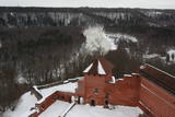 |
Construction of the Sigulda castle was begun by the Order of Brethren of Swords in 1207, but in 1236 it was rebuilt for the needs of the Livonian Order. The building suffered much damage during wars in the latter half of the 16th century and the early part of the 17th century. It was burned down during the Great Northern War and was not restored. Visible today is the south-western wing of the castle’s convent building and the main gate tower, behind which is the internal forecastle with an open-air stage that offers an impressive view of the ancient Gauja River valley. The new Sigulda castle was built between 1878 and 1881, and it was owned by Count Kropotkin. From 1923 until 1940, the castle housed a centre for writers, and during the Soviet Union it was a hospital for cardiology patients. Since 2003, the Sigulda Administrative District Council has been located here. The buildings that have been preserved include a wooden home (mid-19th century), where the Kropotkin family used to live, a granary (late 18th or early 19th century), the home of the gardener (19th century) and a brick wall (19th century). If we go to the north-eastern direction, we will find the Vējupīte valley less than two kilometres away. It includes the shallow (3.6 m) but high (6.1 m) Pēteris cave and the deep Pūču valley with the little Kraukļupīte River. At the place where the two valleys come together we find the Satezele castle hill (its flat surface is 90 x 75 m), where, in the early 13th century, the oak castle of the ruler of Livonian lands, Dabrelis, was once found. Nearby is the Kraukļu valley, with 11 m sandstone walls and a cave that is 5.2 m deep. Nearby is the Paradise (Painter) hill, which offers a lovely landscape that has been painted and photographed since ancient times. There is a Ferris wheel in the western part of Sigulda that is open during the summer, as well as an aerial tram that is the only transport vehicle of its type in the Baltic States and was installed in 1969. The cable that carries the tram is 1,060 metres long and links the shores of the ancient Gauja River valley between Sigulda and Krimulda. The cable is approximately 40 metres above the Gauja. The south-western part of Sigulda features the mighty Beite cliff which is split by a deep stream valley. To the west of the cliff is the Emperor’s View viewing area that is 67 m above the Gauja and offers a good view of Krimulda and the Turaida Castle. A viewing area was established here in 1862, when Tsar Alexander II of Russia visited Sigulda. The wooden Emperor’s chair is to the east of the viewing area. The Turaida Museum Reserve is in the place where the shore is split by deep valleys carved out by streams. It features several outstanding monuments that are as much as 1,000 years old. Of note are the Turaida Estate (21 buildings), the grave of the Rose of Turaida, the Turaida Lutheran Church (1750), which is one of the oldest wooden churches in Latvia) and the Turaida Castle. Folksong hill, which is nearby, is used for various thematic events. |
|
 |
This is an ancient populated area. There were 50 homesteads here during the 1930s, with only ten remaining in 1990. The Livonian scholar and entomologist Kārlis Princis (1893-1978) was born in Oviši. In 1944, he emigrated to Sweden. The Oviši lighthouse (1814) is 38 metres high and is the oldest functioning lighthouse in Latvia. There are lovely views from the top of the lighthouse. The building in which employees of the lighthouse used to live was erected in 1905 and has been preserved. A narrow-gauge train station was in the building at one time. The Oviši Lighthouse Museum is nearby, as is the metal Tree of Austra. Opposite Cape Oviši is a great place for bird watching. |
|
 |
The largest town in the region dates back to the 19th century, when three local fishing villages – Neibāde, Pēterupe and Katrīnbāde – became a popular location for leisure and swimming. This led to the construction of many summer homes, and the development of the spa was facilitated by the opening of a rail line between Rīga and Saulkrasti in 1905. New spas and restaurants were opened, and the spa infrastructure was developed. During the summer there were various entertainments, including balls and concerts featuring orchestras from Rīga. Also facilitating the development of the spa was a road and railroad line between Rīga and Saulkrasti that were installed during the 1930s. During the Soviet occupation, leisure homes, sanatoriums and new summer homes were built in Saulkrasti, which was given the status of a city. Today Saulkrasti is attractive because of its white sand beach, as well as various annual events, the Saulriets trail, the White Dune, the unique bicycle museum, Sea Park, the “Centrs” swimming facility, Sun Square, etc. |
|
 |
Plavinas and Stukmani region was inhabited already in the third century. During the Polish-Swedish War (1600-1629) at estuary of Aivekste in the Daugava River the Swedish war camp was formed, from which are preserved fortifications - bastions. They are one of the most impressive military formations of this kind in Latvia. Plavinas as a larger populated area started to develop in the nineties of the 19th century and in the beginning of 20th century after the construction of railway. Today Plavinas are more commonly known with dolomite production sites and spring flood area. |
|
