
| No | Name | Description |
|---|---|---|
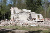 |
The communications facility in the forests of Bārta has been abandoned and is not being used other than for dismantling of buildings to obtain building materials.
|
|
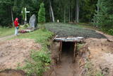 |
In October 1948, nationalist partisans who opposed the Soviet regime built a 9x6 m bunker in the forests of Īle for themselves. Five months later, the KGB attacked the bunker. After five hours of gunfire, 15 partisans lay dead, and another nine were captured. The bunker has been restored in commemoration of this event, and it is open to visitors.
|
|
 |
The Northern Forts of Liepāja are on the edge of the Baltic Sea, and some parts of them have been washed away. This is a small, but very impressive part of the Liepāja fortifications which once encircled the entire town. The underground bunkers of the forts are on two levels, and it’s worth visiting them in the company of a knowledgeable guide from Karosta (tours are organised from the Karosta prison). There’s a car park alongside the forts. It’s also worth walking down the beach for a distance of around four kilometres to the Northern breakwater. On the shore and in the sea, you’ll see two coastal defence batteries and some pretty impressive views.
|
|
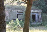 |
The 77th Zenith Missile Brigade of the Soviet Army was charged with air defences along the Soviet Union’s external border. The facility is owned by the regional local government and is not used for anything. There is an interesting gate at the entrance to the facility, however.
|
|
 |
This former training route runs through the shoreline forests from the northern part of Ventspils (there was once a tank division in Ziemeļu Street there) all the way to Ovīši. Today it is a wide, sandy and overgrown track.
|
|
