
| No | Name | Description |
|---|---|---|
 |
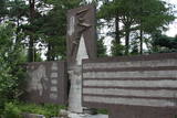
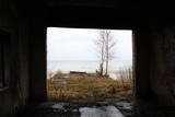
The coast guard facility is not used at this time. Still there is a monument, a border post, and lavatories with wooden toilet paper holders. A good view of the facility can be seen from the high barrier along its southern edge.
|
|
 |
This facility was used in the past by communications officers, and it was also a training centre. The Ventspils Home Guard Battalion is housed here at this time. The facility is not open to civilians. Along the road there are metal structures which show where the entrance to the facility was once located.
|
|
 |
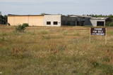
This extensive territory to the South of Pāvilosta once was the site of warehouses and an oil base. The territory at this time is used for the extraction of raw materials. There is also a sawmill there. The sign at the entrance of the facility states that the area can be dangerous to visitors.
|
|
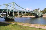 |
The bridge was built in 1906. Part of it was blown up during World War I and later restored. During the Soviet occupation, one needed special permits to cross the bridge. Military ships and other vessels used the canal, because one of the largest military bases in the USSR was sited here. In the summer of 2006, one month before the bridge’s centenary, a Georgian-flagged tanker, the Anna, rammed into the northern support structure of the bridge, and that destroyed the bridge’s turning part beyond recognition. The bridge was renovated and reopened in 2009. You can look at the bridge and cross it at any time.This is a unique engineering monument, and it is the only drawbridge of its kind in the Baltic States. It takes just five minutes to turn the two parts of the bridge.
|
|
 |
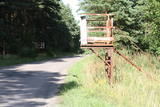
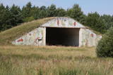
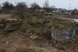
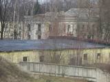
In Soviet times, the border guards of Ventspils established a major complex of buildings, open areas and various objects. Most of these are no longer in use, and the area is not under guard.
|
|
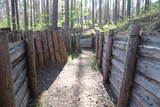 |
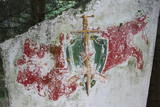
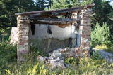
Ar Kara muzeja informatīvo atbalstu Garā kāpā pie Antiņiem ir rekonstruēta daļa latviešu strēlnieku nocietinājumu sistēmas. Aspkatāmas ierakumu pozīcijas un vairākas zemnīcas. Netālu atrodas bijusī un no dzelzsbetona veidotā medikamentu glabātuve. |
|
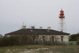 |
In Soviet times, all lighthouses were military objects. Today the lighthouse at Pape is managed by the Latvian Maritime Administration, and it can only be viewed from the outside.
|
|
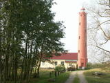 |
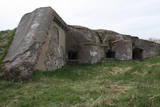
This was Coastal Defence Battery No. 500 at one time, and it was dismantled in 1955. There were four 130 mm cannons, and their foundations can still be spotted in the forest northeast from the lighthouse. They are mostly covered by moss and can be very hard to find. Those who are not familiar with the region will probably have the most trouble of all.
|
|
 |
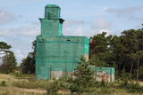
There are still some buildings, missile silos and an apartment building from the old No. 158 Zenith Missile Base at Ziemupe, but the territory has been abandoned and degraded.
|
|
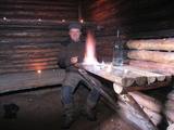 |
Metsavenna Farm organises forest brethren (or brothers) expeditions for visitors to search out forest brothers in their hideouts, visit an underground bunker, hear true stories of life after WWII, have a taste of home-brew and sing old songs along with the master. The more adventurous can stay a night in the bunker, while in winter a sledding hill is opened for snowy downhill rides. |
|
 |
Spilves pļavas tika izmantotas kara aviācijas vajadzībām jau 1. Pasaules kara laikā. 1922. gadā bumbu sabojātā lidlauka atjaunošanu veica Latvijas Republikas Aviācijas divizions Jāzepa Baško vadībā. Drīz pēc tam Spilvē 51 hektāru lielā teritorijā pie Rīgas - Bolderājas dzelzceļa atzara un šosejas iekārtoja arī civilo lidostu, kuru no Rīgas pilsētas nomāja Latvijas Pasta un telegrāfa departaments. |
|
 |
A coast guard facility was located near the village of Užava during Soviet times. There is a lack of information about the use of the facility at this time.
|
|
 |
Today it seems unbelievable that just 20 years ago there were buildings on the coastline with massive projectors that were rolled onto a platform at night so as to shed light on the nearby sea and beach and to look for potential violators of the border regime. Only the buildings and the ruins of the platform are still there – they have been seriously damaged by the waves of the sea.
|
|
 |
The job for the No. 15 Radio Technology Brigade at Saraiķi was to defend Soviet Latvia’s shoreline back in Soviet times. Today the facility is owned by the Defence Ministry, and the No. 17 Home Guard Battalion uses it for training purposes.
|
|
 |
On the shore of the Daugava River, to the East of Lielupes Street and South-east of Jātnieku Street, there are the remnants of four battery positions that were blown up in their day. The batteries had 152-mm cannons, and this was part of the former system of fortifications in Rīga (see also Komētforts, the Daugavgrīva fortress, and the fortifications of Mangaļsala). The aim was to protect the city from invaders who came from the sea. From the top of the batteries you can see the Daugava and the northern segment of the manmade Krievu Island (a huge pile of sand). It does have to be said that the condition of this historical monument is quite pitiful.
|
|
 |
This is a closed and guarded territory on the banks of Lake Būšnieks in Staldzene. The former project building is on the shore of the sea.
|
|
 |
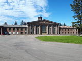
The Swedish army built a modern fortress during the 1640s with five bastions and two gates. There were 120 cannons and mortar throwers, barracks for soldiers, flats for officers, a garrison church and warehouses for food at munitions. After the Great Northern War in 1710, the fortress was taken over by the Russian army. After the Soviet occupation in 1940, the Soviet navy took over the fortress. Alongside it is a former Soviet army facility with abandoned buildings and a monument to sailors who served in submarines. The fortress is open for tours on Saturdays and Sundays. |
|
 |
In addition to the Northern Forts, coastal batteries and Karosta district of Liepāja that are all mentioned in this database, there are other impressive elements of the former fortifications system – Lunete (the southern part of Lake Tosmare), the Central Fort (between Grīzupes Street and 14 November Boulevard), the Eastern Fort (to the South of Brīvības Street and the North of Lake Liepāja), the Southern Fort (at the Pērkone canal), and the Old Forts at the Olimpija stadium. All of these locations are freely accessible, but be careful if you go inside the former forts – they were blown up at one time and may remain dangerous.
|
|
 |
The Plāņciems missile base is in the forests of Bārta and is not easy to access. This special air defence facility is being dismantled for the purpose of obtaining building materials.
|
|
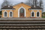 |
Ramocku stacija atklāta 1889. gadā reizē ar dzelzceļa Pleskava-Rīga atklāšanu. 1916.gadā pēc jauna dzelzceļa izbūves līdz Gulbenei, šīs stacijas nozīme ievērojami pieauga. 1918.gadā tā kļuva par divu dažādu sliežu platumu dzelzceļa iecirkņu saskares staciju. Intensīva vilcienu kustība caur šo staciju tika izvērsta Brīvības cīņu laikā. Sadursmes pie Ieriķu stacijas notika jau 1918.gada decembrī. 1919.gadā jūnijā te sākās Cēsu kaujas. Starp Cēsīm un Ieriķiem vācieši uzbruka igauņu bruņuvilcienam. Par dažādiem nopelniem Brīvības cīņu laikā Ieriķu apkaimē, vairāki karavīri saņēma apbalvojumus, arī Lācplēša kara ordeņus.1919. gadā stacija nodēvēta par Ieriķiem. Otrā pasaules kara laikā te atradās lokomotīvju depo.1953.gadā depo vietā izveidoja stratēģiskās rezerves tvaika lokomotīvju bāzi. Pēdējā tvaika lokomotīve L-3599 Ieriķu bāzi pameta 2002.gadā un tagad ir redzama kinopilsētā Cinevilla.Ieriķu stacija vairākkārt pārbūvēta.Otrā pasaules kara laikā nodedzināta pavisam. 1956.gadā uzbūvē pašreizējo ēku. |
|
